Edgemont, Arkansas
| Edgemont, Arkansas | |
|---|---|
| Unincorporated community | |
 Edgemont, Arkansas  Edgemont, Arkansas | |
| Coordinates: 35°36′08″N 92°11′47″W / 35.60222°N 92.19639°WCoordinates: 35°36′08″N 92°11′47″W / 35.60222°N 92.19639°W | |
| Country | United States |
| State | Arkansas |
| County | Cleburne |
| Elevation | 574 ft (175 m) |
| Time zone | Central (CST) (UTC-6) |
| • Summer (DST) | CDT (UTC-5) |
| ZIP code | 72044 |
| Area code(s) | 501 |
| GNIS feature ID | 57700[1] |
Edgemont is an unincorporated community in Cleburne County, Arkansas, United States. Edgemont is located on the north side of Greers Ferry Lake along Arkansas Highway 16, 2 miles (3.2 km) northwest of Greers Ferry. Edgemont has a post office with ZIP code 72044.[2]
Education
Public education for elementary and secondary students is provided by West Side School District, West Side Elementary School and West Side High School located in Greers Ferry. The district encompasses more than 147.81 square miles (382.8 km2) of land that includes all or portions of Cleburne County and Van Buren County communities including: Higden, Bee Branch, Quitman, Heber Springs, Prim, Edgemont, Shirley, Fairfield Bay, Greers Ferry, and Drasco.
References
Municipalities and communities of Cleburne County, Arkansas, United States | ||
|---|---|---|
| Cities | 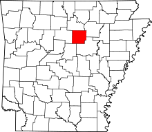 | |
| Towns | ||
| CDP | ||
| Unincorporated communities | ||
| Footnotes | ‡This populated place also has portions in an adjacent county or counties | |
This article is issued from Wikipedia - version of the 7/29/2016. The text is available under the Creative Commons Attribution/Share Alike but additional terms may apply for the media files.