Ponta João Ribeiro
| Ponta João Ribeiro | |
|---|---|
|
The point (then written as Ribeira Julian) is nearly in the middle of the map | |
 | |
| Location | Northwestern São Vicente, Cape Verde |
| Coordinates | 16°54′22″N 24°59′56″W / 16.906°N 24.999°WCoordinates: 16°54′22″N 24°59′56″W / 16.906°N 24.999°W |
| Offshore water bodies |
Porto Grande Bay Canal de São Vicente |
| Length | 1 km |
| Depth | 10 m |
_p0173_CAPE_VERDES%2C_PORTO_GRANDE.jpg)
Ponta João Ribeiro is a cape in the northern part of the island of São Vicente, Cape Verde. It is nearly 3 km north of the island capital of Mindelo, it recently forms the northern urban area and the city of Mindelo and belongs to the neighborhood of Laginha (or Lajinha). The cape divides the Canal de São Vicente and the Porto Grande Bay. The islet of Ilhéu dos Pássaros is approximately 1.3 km to the west. Cliffs dominate the north and slopey areas in the south and one portion artificial land.
Near the cape is an abandoned military camp used by the Portuguese during the Portuguese rule until 1975 and has several buildings that are now a monument. It now serves as a fishing factory
Urban development in the late 2000s reached the point's area, In 2013, street plan were created up to the area of the point and a year later housing developments, luxury houses started to be built, so far, about ten of them have been built as of 2016.
External links
- João Ribeira on mindelo.info (French)
See also
The island of São Vicente and the surrounding islands | ||
|---|---|---|
| Communities and settlements | 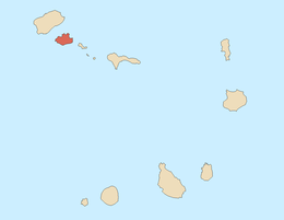 | |
| Parish | ||
| Mountains |
| |
| Streams |
| |
| Surrounding islet | ||
| Other geographical features |
| |
| Culture
| ||