Pine Apple Historic District
|
Pine Apple Historic District | |
|
The Bank of Pine Apple building, now used as an art gallery | |
  | |
| Location | Pine Apple, Alabama |
|---|---|
| Coordinates | 31°52′14″N 86°59′22″W / 31.87056°N 86.98944°WCoordinates: 31°52′14″N 86°59′22″W / 31.87056°N 86.98944°W |
| Architectural style | Bungalow/Craftsman, Colonial Revival |
| NRHP Reference # | 99000248[1] |
| Added to NRHP | February 26, 1999 |
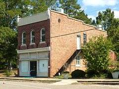
The Pine Apple Historic District is a historic district in the community of Pine Apple, Alabama. It was placed on the National Register of Historic Places on February 26, 1999.[1] The boundaries are roughly Wilcox County roads 59, 7 and 61, Broad Street, Banana Street, AL 10, and Adams Drive. It contains 3,350 acres (1,360 ha), 54 buildings, and 1 structures ranging from the Craftsman to Colonial Revival styles.[2]
See also
References
| Wikimedia Commons has media related to Pine Apple Historic District. |
- 1 2 National Park Service (2008-04-15). "National Register Information System". National Register of Historic Places. National Park Service.
- ↑ Farris, Jonathan A.; Trina Binkley (October 29, 1998). "Pine Apple Historic District" (PDF). National Register of Historic Places Registration Form. National Park Service. Archived from the original on March 10, 2014. Retrieved March 10, 2014. See also: "Accompanying photos" (PDF). Archived from the original on March 10, 2014. Retrieved March 10, 2014.

This article is issued from Wikipedia - version of the 11/28/2016. The text is available under the Creative Commons Attribution/Share Alike but additional terms may apply for the media files.