| [3] |
Name on the Register |
Image |
Date listed[4] |
Location |
City or town |
Description |
|---|
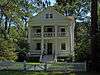
| 1 |
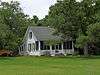
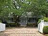
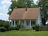
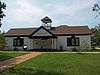
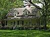
Allen House |
|
000000001988-12-20-0000December 20, 1988
(#88002809) |
Off County Road 10 on the northern bank of the Bon Secour River
30°18′09″N 87°44′13″W / 30.3025°N 87.736944°W / 30.3025; -87.736944 (Allen House) |
Bon Secour |
|
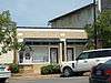
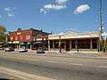
| 2 |
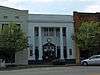
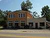
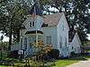
Bank of Fairhope |
|
000000001988-07-01-0000July 1, 1988
(#88001008) |
396 Fairhope Ave.
30°31′22″N 87°54′12″W / 30.522778°N 87.903333°W / 30.522778; -87.903333 (Bank of Fairhope) |
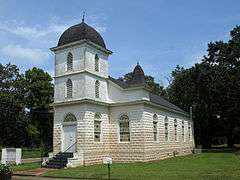
Fairhope |
|
| 3 |
Battles Wharf Historic District |
Upload image |
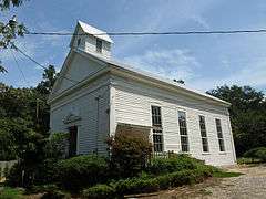
000000001988-04-28-0000April 28, 1988
(#88000107) |
U.S. Route 98 (Eastern Shore Boulevard) roughly between Woolworth Ave. and Buerger La.
30°29′37″N 87°55′38″W / 30.493611°N 87.927222°W / 30.493611; -87.927222 (Battles Wharf Historic District) |
Battles Wharf |
|
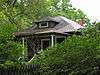
| 4 |
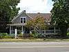
Beckner House |
|
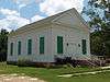
000000001988-07-01-0000July 1, 1988
(#88001007) |
63 S. Church St.
30°31′15″N 87°54′17″W / 30.520833°N 87.904722°W / 30.520833; -87.904722 (Beckner House) |
Fairhope |
|
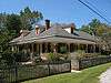
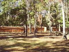
| 5 |
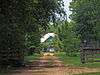
Blakeley |
|
000000001974-06-25-0000June 25, 1974
(#74000397) |
Along the Tensaw River north of Spanish Fort[5]
30°44′32″N 87°55′27″W / 30.742222°N 87.924167°W / 30.742222; -87.924167 (Blakeley) |
Spanish Fort |
|
| 6 |
Carl L. Bloxham Building |
|
000000001988-06-30-0000June 30, 1988
(#88001005) |
327 Fairhope Ave.
30°31′23″N 87°54′15″W / 30.523056°N 87.904167°W / 30.523056; -87.904167 (Carl L. Bloxham Building) |
Fairhope |
|
| 7 |
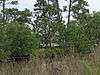
Bottle Creek Indian Mounds |
|
000000001974-12-02-0000December 2, 1974
(#74000398) |
Northern end of Mound Island along the eastern side of the Middle River[6]
31°00′32″N 87°56′24″W / 31.008889°N 87.940000°W / 31.008889; -87.940000 (Bottle Creek Indian Mounds) |
Stockton |
|
| 8 |
Brodbeck-Zundel Historic District |
|
000000001988-04-28-0000April 28, 1988
(#88000520) |
Scenic U.S. Route 98 and Old Marlow Rd.
30°28′27″N 87°55′09″W / 30.474167°N 87.919167°W / 30.474167; -87.919167 (Brodbeck-Zundel Historic District) |
Point Clear |
|
| 9 |
Brunell House |
|
000000001995-08-22-0000August 22, 1995
(#95001019) |
12113 Jessamine St.
30°24′02″N 87°46′36″W / 30.400556°N 87.776667°W / 30.400556; -87.776667 (Brunell House) |
Magnolia Springs |
|
| 10 |
Captain Adams House |
Upload image |
000000001988-12-20-0000December 20, 1988
(#88002810) |
907 Captain O'Neal Dr.
30°35′25″N 87°54′51″W / 30.590278°N 87.914167°W / 30.590278; -87.914167 (Captain Adams House) |
Daphne |
|
| 11 |
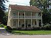
George W. Cullum House |
Upload image |
000000001990-06-14-0000June 14, 1990
(#90000930) |
1915 Old County Rd.
30°36′19″N 87°54′39″W / 30.605278°N 87.910833°W / 30.605278; -87.910833 (George W. Cullum House) |
Daphne |
|
| 12 |
Fairhope Bayfront District |
|
000000001988-07-01-0000July 1, 1988
(#88001003) |
Roughly bounded by Blakeney, N. and S. Summit Sts., Fels Ave., and Mobile Bay
30°31′28″N 87°54′32″W / 30.524444°N 87.908889°W / 30.524444; -87.908889 (Fairhope Bayfront District) |
Fairhope |
|
| 13 |
Fairhope Downtown Historic District |
|
000000002006-03-16-0000March 16, 2006
(#04000115) |
Roughly bounded by Equality St., Fairhope Ave., Morphy Ave., School St., and Summit St.
30°31′21″N 87°54′11″W / 30.5225°N 87.903056°W / 30.5225; -87.903056 (Fairhope Downtown Historic District) |
Fairhope |
|
| 14 |
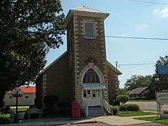
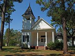
First Baptist Church |
|
000000001988-08-25-0000August 25, 1988
(#88001349) |
Northern side of D'Olive St.
30°53′05″N 87°46′36″W / 30.884722°N 87.776667°W / 30.884722; -87.776667 (First Baptist Church) |
Bay Minette |
|
| 15 |
Foley Downtown Historic District |
|
000000002005-01-19-0000January 19, 2005
(#04001496) |
Parts of Alston, McKenzie, E. and W. Laurel and W. Orange Sts.
30°24′24″N 87°41′02″W / 30.406667°N 87.683889°W / 30.406667; -87.683889 (Foley Downtown Historic District) |
Foley |
Boundaries originally encompassed parts of Alston, N. and S. McKenzie, U.S. Route 98, E. and W. Laurel, Myrtle, Rose, and W. Orange until a boundary decrease of 000000002012-06-04-0000June 4, 2012
|
| 16 |
Fort Mims Site |
|
000000001972-09-14-0000September 14, 1972
(#72000153) |
Southwestern quarter of Section 36, Township 2 North, Range 2 East[7]
31°10′50″N 87°50′17″W / 31.18050°N 87.83797°W / 31.18050; -87.83797 (Fort Mims Site) |
Tensaw |
Site of a battle during the Creek War. On August 30, 1813, Red Stick Creeks killed or captured 517 settlers, militia, and their allies at Fort Mims.
|
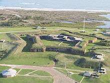
| 17 |
Fort Morgan |
|
000000001966-10-15-0000October 15, 1966
(#66000146) |
Western terminus of State Route 180
30°13′41″N 88°01′23″W / 30.228056°N 88.023056°W / 30.228056; -88.023056 (Fort Morgan) |
Gasque |
|
| 18 |
Gaston Building |
|
000000001988-07-01-0000July 1, 1988
(#88001004) |
336 Fairhope Ave.
30°31′22″N 87°54′14″W / 30.522778°N 87.903889°W / 30.522778; -87.903889 (Gaston Building) |
Fairhope |
|
| 19 |
Golf, Gun & Country Club |
|
000000001988-07-01-0000July 1, 1988
(#88001002) |
651 Johnson Ave.
30°31′22″N 87°53′41″W / 30.522778°N 87.894722°W / 30.522778; -87.894722 (Golf, Gun & Country Club) |
Fairhope |
|
| 20 |
Governor's Club |
|
000000002000-08-31-0000August 31, 2000
(#00001031) |
11866 Magnolia St.
30°23′46″N 87°46′34″W / 30.396111°N 87.776111°W / 30.396111; -87.776111 (Governor's Club) |
Magnolia Springs |
|
| 21 |
Hamner House |
|
000000001988-12-20-0000December 20, 1988
(#88002811) |
Oak Rd. off County Road 6
30°19′07″N 87°42′27″W / 30.318611°N 87.7075°W / 30.318611; -87.7075 (Hamner House) |
Bon Secour |
|
| 22 |
Axil Johnson House |
|
000000001997-07-03-0000July 3, 1997
(#97000649) |
751 Edwards St.
30°31′39″N 87°53′24″W / 30.5275°N 87.89°W / 30.5275; -87.89 (Axil Johnson House) |
Fairhope |
|
| 23 |
Killcreas House |
|
000000001995-05-04-0000May 4, 1995
(#95000556) |
46833 State Route 225
30°54′26″N 87°51′23″W / 30.907222°N 87.856389°W / 30.907222; -87.856389 (Killcreas House) |
Bay Minette |
|
| 24 |
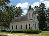
Latham United Methodist Church |
|
000000001988-08-25-0000August 25, 1988
(#88001350) |
Eastern side of State Route 59
31°05′54″N 87°49′51″W / 31.098333°N 87.830833°W / 31.098333; -87.830833 (Latham United Methodist Church) |
Latham |
|
| 25 |
Lebanon Chapel AME Church |
|
000000001988-08-25-0000August 25, 1988
(#88001351) |
Bounded by Young St. on the west and Middle St. on the north
30°30′48″N 87°53′39″W / 30.513333°N 87.894167°W / 30.513333; -87.894167 (Lebanon Chapel AME Church) |
Fairhope |
|
| 26 |
Magnolia Springs Historic District |
|
000000002012-01-27-0000January 27, 2012
(#11001046) |
Roughly along Oak, Spring, Bay, Jessamine, Magnolia, Pine & Rock Sts., Island, Cedar & Holly Aves. & Magnolia Springs Highway
30°23′59″N 87°46′34″W / 30.399642°N 87.7761°W / 30.399642; -87.7761 (Magnolia Springs Historic District) |
Magnolia Springs |
|
| 27 |
Malbis Plantation |
|
000000002011-05-10-0000May 10, 2011
(#11000238) |
10145 US 90
30°39′13″N 87°50′32″W / 30.653611°N 87.842222°W / 30.653611; -87.842222 (Malbis Plantation) |
Daphne |
|
| 28 |
McMillan House |
|
000000001988-12-20-0000December 20, 1988
(#88002812) |
1404 Captain O'Neal Ave.
30°35′52″N 87°54′42″W / 30.597778°N 87.911667°W / 30.597778; -87.911667 (McMillan House) |
Daphne |
|
| 29 |
Methodist Episcopal Church, South |
|
000000001980-09-22-0000September 22, 1980
(#80000679) |
1608 Old County Rd.
30°36′06″N 87°54′31″W / 30.601667°N 87.908611°W / 30.601667; -87.908611 (Methodist Episcopal Church, South) |
Daphne |
|
| 30 |
Montgomery Hill Baptist Church |
|
000000001988-08-25-0000August 25, 1988
(#88001352) |
Eastern side of State Route 59 on County Road 80
31°09′46″N 87°47′12″W / 31.162778°N 87.786667°W / 31.162778; -87.786667 (Montgomery Hill Baptist Church) |
Tensaw |
|
| 31 |
Montrose Historic District |
|
000000001976-06-03-0000June 3, 1976
(#76000310) |
Main (State Route 42) and 2nd Sts.
30°34′07″N 87°54′02″W / 30.568611°N 87.900556°W / 30.568611; -87.900556 (Montrose Historic District) |
Montrose |
|
| 32 |
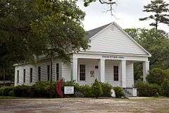
Moore Store |
|
000000002001-11-30-0000November 30, 2001
(#00001027) |
14770 Oak St.
30°24′04″N 87°46′15″W / 30.401111°N 87.770833°W / 30.401111; -87.770833 (Moore Store) |
Magnolia Springs |
|
| 33 |
Nelson House |
|
000000001988-12-20-0000December 20, 1988
(#88002814) |
State Route 59, North
31°05′08″N 87°49′52″W / 31.085556°N 87.831111°W / 31.085556; -87.831111 (Nelson House) |
Latham |
|
| 34 |
Nicholson House |
|
000000001988-12-20-0000December 20, 1988
(#88002813) |
County Road 6
30°17′33″N 87°44′13″W / 30.2925°N 87.736944°W / 30.2925; -87.736944 (Nicholson House) |
Oyster Bay |
|
| 35 |
Orrell House |
|
000000001988-12-20-0000December 20, 1988
(#88002815) |
County Road 6
30°18′59″N 87°42′14″W / 30.316389°N 87.703889°W / 30.316389; -87.703889 (Orrell House) |
Bon Secour |
|
| 36 |
People's Supply Company |
|
000000001997-02-21-0000February 21, 1997
(#97000096) |
21950 Broad St.
30°32′41″N 87°45′03″W / 30.544722°N 87.750833°W / 30.544722; -87.750833 (People's Supply Company) |
Silverhill |
|
| 37 |
Point Clear Historic District |
Upload image |
000000001988-04-28-0000April 28, 1988
(#88000515) |
Western side of U.S. Route 98/Eastern Shore Boulevard
30°28′48″N 87°55′40″W / 30.48°N 87.927778°W / 30.48; -87.927778 (Point Clear Historic District) |
Point Clear |
|
| 38 |
St. Mark's Lutheran Church |
|
000000001988-08-25-0000August 25, 1988
(#88001353) |
Western side of County Road 83
30°25′01″N 87°35′55″W / 30.416944°N 87.598611°W / 30.416944; -87.598611 (St. Mark's Lutheran Church) |
Elberta |
|
| 39 |
St. Patrick's Catholic Church |
|
000000001988-08-25-0000August 25, 1988
(#88001354) |
Eastern side of U.S. Route 90
30°37′11″N 87°45′10″W / 30.619722°N 87.752778°W / 30.619722; -87.752778 (St. Patrick's Catholic Church) |
Loxley |
|
| 40 |
St. Paul's Episcopal Church |
|
000000001988-08-25-0000August 25, 1988
(#88001355) |
Northern side of Oak Ave.
30°24′05″N 87°46′17″W / 30.401389°N 87.771389°W / 30.401389; -87.771389 (St. Paul's Episcopal Church) |
Magnolia Springs |
|
| 41 |
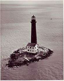
Sand Island Light |
|
000000001975-11-12-0000November 12, 1975
(#75000305) |
Southwest of Fort Morgan off Mobile Point
30°11′15″N 88°03′02″W / 30.1875°N 88.050556°W / 30.1875; -88.050556 (Sand Island Light) |
Fort Morgan |
|
| 42 |
School of Organic Education |
|
000000001988-07-01-0000July 1, 1988
(#88001010) |
Bounded by Fairhope and Morphy Aves. and Bancroft and School Sts.
30°31′17″N 87°54′05″W / 30.521389°N 87.901389°W / 30.521389; -87.901389 (School of Organic Education) |
Fairhope |
|
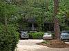
| 43 |
Lewis Starke House |
Upload image |
000000001990-06-14-0000June 14, 1990
(#90000929) |
2103 Old County Rd.
30°36′26″N 87°54′39″W / 30.607222°N 87.910833°W / 30.607222; -87.910833 (Lewis Starke House) |
Daphne |
|
| 44 |
State Bank Silverhill |
|
000000002001-12-31-0000December 31, 2001
(#01001410) |
15950 Silverhill Ave.
30°32′42″N 87°45′05″W / 30.545°N 87.751389°W / 30.545; -87.751389 (State Bank Silverhill) |
Silverhill |
|
| 45 |
Stockton Methodist Church |
|
000000001988-08-25-0000August 25, 1988
(#88001356) |
Eastern side of State Route 59
31°00′57″N 87°51′11″W / 31.015833°N 87.853056°W / 31.015833; -87.853056 (Stockton Methodist Church) |
Stockton |
|
| 46 |
Street House |
|
000000001988-12-20-0000December 20, 1988
(#88002816) |
Wood Acres Rd. off County Road 3
30°27′52″N 87°53′54″W / 30.464444°N 87.898333°W / 30.464444; -87.898333 (Street House) |
Point Clear |
|
| 47 |
Henry Stuart House |
|
000000002006-10-27-0000October 27, 2006
(#05000841) |
22787 U.S. Route 98
30°33′23″N 87°53′38″W / 30.556389°N 87.893889°W / 30.556389; -87.893889 (Henry Stuart House) |
Montrose |
|
| 48 |
Sunnyside Hotel |
|
000000001998-02-20-0000February 20, 1998
(#98000111) |
14469 Oak St.
30°23′59″N 87°46′36″W / 30.399722°N 87.776667°W / 30.399722; -87.776667 (Sunnyside Hotel) |
Magnolia Springs |
|
| 49 |
Svea Land Company Office |
|
000000001985-03-07-0000March 7, 1985
(#85000443) |
S. 6th St.
30°32′41″N 87°45′14″W / 30.544722°N 87.753889°W / 30.544722; -87.753889 (Svea Land Company Office) |
Silverhill |
|
| 50 |
Swift Presbyterian Church |
|
000000001988-08-25-0000August 25, 1988
(#88001357) |
Swift Church Rd.
30°22′30″N 87°37′41″W / 30.375°N 87.628056°W / 30.375; -87.628056 (Swift Presbyterian Church) |
Miflin |
|
| 51 |
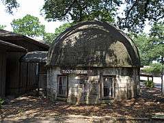
The Texas |
|
000000001988-12-20-0000December 20, 1988
(#88002817) |
306 Dryer Ave.
30°36′02″N 87°54′37″W / 30.600556°N 87.910278°W / 30.600556; -87.910278 (The Texas) |
Daphne |
|
| 52 |
Twin Beach AME Church |
|
000000001988-08-25-0000August 25, 1988
(#88001358) |
Southern side of County Road 44
30°30′04″N 87°54′34″W / 30.501111°N 87.909444°W / 30.501111; -87.909444 (Twin Beach AME Church) |
Fairhope |
|
| 53 |
U.S.S. TECUMSEH |
|
000000001975-05-14-0000May 14, 1975
(#75000306) |
Northwest of Fort Morgan in Mobile Bay
30°13′54″N 88°01′33″W / 30.231667°N 88.025833°W / 30.231667; -88.025833 (U.S.S. TECUMSEH) |
Fort Morgan |
|
| 54 |
US Post Office |
|
000000001988-07-01-0000July 1, 1988
(#88001001) |
325 Fairhope Ave.
30°31′23″N 87°54′15″W / 30.523056°N 87.904167°W / 30.523056; -87.904167 (US Post Office) |
Fairhope |
|
| 55 |
Walker House |
Upload image |
000000001988-12-20-0000December 20, 1988
(#88002818) |
905 Captain O'Neal Dr.
30°35′23″N 87°54′51″W / 30.589722°N 87.914167°W / 30.589722; -87.914167 (Walker House) |
Daphne |
|
| 56 |
White Avenue Historic District |
|
000000001988-07-01-0000July 1, 1988
(#88001009) |
White Ave.
30°31′10″N 87°54′04″W / 30.519444°N 87.901111°W / 30.519444; -87.901111 (White Avenue Historic District) |
Fairhope |
|
| 57 |
Whittier Hall |
|
000000001985-03-07-0000March 7, 1985
(#85000442) |
201 Magnolia Ave.
30°31′29″N 87°53′45″W / 30.524722°N 87.895833°W / 30.524722; -87.895833 (Whittier Hall) |
Fairhope |
|
| 58 |
Zurhorst House |
|
000000001988-07-01-0000July 1, 1988
(#88001006) |
200 Fels Ave.
30°31′16″N 87°54′23″W / 30.521111°N 87.906389°W / 30.521111; -87.906389 (Zurhorst House) |
Fairhope |
|


.jpg)
_Sept_2012.jpg)