| [3] |
Name on the Register |
Image |
Date listed[4] |
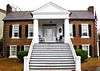
Location |
City or town |
Description |
|---|
| 1 |
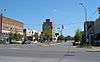
Alabama Insane Hospital |
|
000000001977-04-18-0000April 18, 1977
(#77000216) |
University Boulevard
33°13′00″N 87°32′18″W / 33.216667°N 87.538333°W / 33.216667; -87.538333 (Alabama Insane Hospital) |
Tuscaloosa |
|
| 2 |
Audubon Place Historic District |
Upload image |
000000001985-07-11-0000July 11, 1985
(#85001517) |
1515-1707 (odd) University Boulevard and 8-37 Audubon Pl.
33°12′38″N 87°33′32″W / 33.210556°N 87.558889°W / 33.210556; -87.558889 (Audubon Place Historic District) |
Tuscaloosa |
|
| 3 |
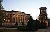
Bama Theatre-City Hall Building |
|
000000001984-08-30-0000August 30, 1984
(#84000746) |
600 Greensboro Ave.
33°12′30″N 87°34′05″W / 33.208333°N 87.568056°W / 33.208333; -87.568056 (Bama Theatre-City Hall Building) |
Tuscaloosa |
|
| 4 |
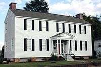
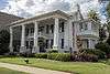
Battle-Friedman House |
|
000000001972-01-14-0000January 14, 1972
(#72000184) |
1010 Greensboro Ave.
33°12′16″N 87°33′59″W / 33.204444°N 87.566389°W / 33.204444; -87.566389 (Battle-Friedman House) |
Tuscaloosa |
|
| 5 |
Byler Road |
Upload image |
000000001974-11-19-0000November 19, 1974
(#74000438) |
11 mi (18 km) north of Northport, off U.S. Route 43
33°23′16″N 87°35′51″W / 33.387778°N 87.5975°W / 33.387778; -87.5975 (Byler Road) |
Northport |
|
| 6 |
Caplewood Drive Historic District |
Upload image |
000000001985-05-30-0000May 30, 1985
(#85001159) |
Roughly bounded by Caplewood Dr., and University Boulevard
33°12′47″N 87°33′22″W / 33.213056°N 87.556111°W / 33.213056; -87.556111 (Caplewood Drive Historic District) |
Tuscaloosa |
|
| 7 |
Carson Place |
|
000000001985-03-07-0000March 7, 1985
(#85000448) |
610 36th Ave.
33°12′19″N 87°35′00″W / 33.205278°N 87.583333°W / 33.205278; -87.583333 (Carson Place) |
Tuscaloosa |
|
| 8 |
City National Bank |
|
000000001985-03-07-0000March 7, 1985
(#85000449) |
2301 University Boulevard
33°12′35″N 87°34′01″W / 33.209722°N 87.566944°W / 33.209722; -87.566944 (City National Bank) |
Tuscaloosa |
|
| 9 |
Collier-Overby House |
|
000000001971-07-14-0000July 14, 1971
(#71000107) |
Southeastern corner of the junction of 9th St. and 21st Ave.
33°12′25″N 87°33′44″W / 33.206944°N 87.562222°W / 33.206944; -87.562222 (Collier-Overby House) |
Tuscaloosa |
|
| 10 |
Downtown Tuscaloosa Historic District |
|
000000001986-05-15-0000May 15, 1986
(#86001084) |
Roughly bounded by 4th St., 22nd Ave., 7th St., and Greensboro Ave.
33°12′35″N 87°34′02″W / 33.209722°N 87.567222°W / 33.209722; -87.567222 (Downtown Tuscaloosa Historic District) |
Tuscaloosa |
|
| 11 |
Druid City Historic District |
|
000000001975-02-24-0000February 24, 1975
(#75000327) |
Roughly bounded by Queen City Pike, 16th St., 15th St., and 21st Ave.
33°12′29″N 87°33′38″W / 33.208056°N 87.560556°W / 33.208056; -87.560556 (Druid City Historic District) |
Tuscaloosa |
|
| 12 |
East Northport Historic District |
Upload image |
000000002004-03-26-0000March 26, 2004
(#04000234) |
Roughly bounded by 20th St., 8th Ave., Rice Mine Rd., and Bridge Ave.
33°13′30″N 87°34′20″W / 33.225°N 87.572222°W / 33.225; -87.572222 (East Northport Historic District) |
Northport |
|
| 13 |
First African Baptist Church |
|
000000001988-09-28-0000September 28, 1988
(#88001580) |
2621 9th St.
33°12′17″N 87°34′12″W / 33.204722°N 87.57°W / 33.204722; -87.57 (First African Baptist Church) |
Tuscaloosa |
|
| 14 |
Fitch House |
Upload image |
000000001987-07-22-0000July 22, 1987
(#87001027) |
3404 6th St.
33°12′20″N 87°34′49″W / 33.205556°N 87.580278°W / 33.205556; -87.580278 (Fitch House) |
Tuscaloosa |
|
| 15 |
Foster Auditorium, The University of Alabama |
|
000000002005-04-05-0000April 5, 2005
(#05000457) |
6th Avenue, on the University of Alabama campus
33°13′15″N 87°32′15″W / 33.220882°N 87.537518°W / 33.220882; -87.537518 (Foster Auditorium, The University of Alabama) |
Tuscaloosa |
|
| 16 |
Foster Home/Sylvan Plantation |
Upload image |
000000001985-03-07-0000March 7, 1985
(#85000451) |
Off U.S. Route 11
33°04′50″N 87°42′09″W / 33.080556°N 87.7025°W / 33.080556; -87.7025 (Foster Home/Sylvan Plantation) |
Tuscaloosa |
|
| 17 |
Gorgas-Manly Historic District |
|
000000001971-07-14-0000July 14, 1971
(#71000108) |
On the University of Alabama campus
33°12′44″N 87°32′45″W / 33.212222°N 87.545833°W / 33.212222; -87.545833 (Gorgas-Manly Historic District) |
Tuscaloosa |
|
| 18 |
Guild-Verner House |
|
000000001973-12-04-0000December 4, 1973
(#73000374) |
1904 University Ave.
33°12′42″N 87°33′43″W / 33.211667°N 87.561944°W / 33.211667; -87.561944 (Guild-Verner House) |
Tuscaloosa |
|
| 19 |
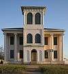
Jemison School-Drish House |
|
000000002015-03-17-0000March 17, 2015
(#14000357) |
2300 17th St.
33°11′51″N 87°33′42″W / 33.1974°N 87.5618°W / 33.1974; -87.5618 (Jemison School-Drish House) |
Tuscaloosa |
|
| 20 |
Robert Jemison Servants' House |
|
000000001990-11-29-0000November 29, 1990
(#90001808) |
2303 13th St.
33°12′08″N 87°33′50″W / 33.202222°N 87.563889°W / 33.202222; -87.563889 (Robert Jemison Servants' House) |
Tuscaloosa |
|
| 21 |
Jemison-Vandegraaff House |
|
000000001972-04-19-0000April 19, 1972
(#72000185) |
1305 Greensboro Ave.
33°12′10″N 87°33′54″W / 33.202778°N 87.565°W / 33.202778; -87.565 (Jemison-Vandegraaff House) |
Tuscaloosa |
|
| 22 |
Samuel Johnson House |
|
000000002002-10-04-0000October 4, 2002
(#02001069) |
Shelley Hughes Rd.
33°16′37″N 87°44′30″W / 33.276944°N 87.741667°W / 33.276944; -87.741667 (Samuel Johnson House) |
Buhl |
|
| 23 |
Murphy-Collins House |
|
000000001993-01-28-0000January 28, 1993
(#92001824) |
2601 Paul Bryant Dr.
33°12′15″N 87°34′09″W / 33.204167°N 87.569167°W / 33.204167; -87.569167 (Murphy-Collins House) |
Tuscaloosa |
|
| 24 |
Northport Historic District |
|
000000001980-05-01-0000May 1, 1980
(#80000736) |
25th, 26th, 28th, and 30th Aves. and Main, 5th, and 6th Sts.
33°13′08″N 87°34′49″W / 33.218889°N 87.580278°W / 33.218889; -87.580278 (Northport Historic District) |
Northport |
|
| 25 |
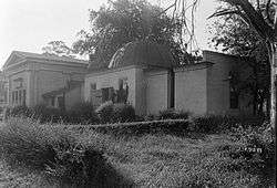
Old Observatory |
|
000000001972-01-14-0000January 14, 1972
(#72000187) |
North of University Boulevard on the University of Alabama campus
33°12′40″N 87°32′57″W / 33.211111°N 87.549167°W / 33.211111; -87.549167 (Old Observatory) |
Tuscaloosa |
|
| 26 |
Old Tuscaloosa County Jail |
|
000000001979-11-28-0000November 28, 1979
(#79000404) |
2803 6th St.
33°12′25″N 87°34′24″W / 33.206944°N 87.573333°W / 33.206944; -87.573333 (Old Tuscaloosa County Jail) |
Tuscaloosa |
|
| 27 |
Pinehurst Historic District |
Upload image |
000000001986-06-05-0000June 5, 1986
(#86001229) |
215 and 305 17th Ave., 1-28 Pinehurst Dr., and 6-9 N. Pinehurst Dr.
33°12′48″N 87°33′29″W / 33.213333°N 87.558056°W / 33.213333; -87.558056 (Pinehurst Historic District) |
Tuscaloosa |
|
| 28 |
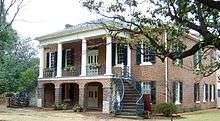
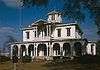
President's Mansion |
|
000000001972-01-14-0000January 14, 1972
(#72000186) |
On the University of Alabama campus
33°12′31″N 87°32′47″W / 33.208611°N 87.546389°W / 33.208611; -87.546389 (President's Mansion) |
Tuscaloosa |
|
| 29 |
Margaret Quayle Lustron House |
|
000000002000-02-24-0000February 24, 2000
(#00000126) |
27 Parkview Dr.
33°11′59″N 87°32′54″W / 33.199722°N 87.548333°W / 33.199722; -87.548333 (Margaret Quayle Lustron House) |
Tuscaloosa |
|
| 30 |
Queen City Pool and Pool House |
|
000000001992-09-10-0000September 10, 1992
(#92001088) |
Junction of Queen City Ave. and Riverside Dr.
33°12′53″N 87°33′48″W / 33.214722°N 87.563333°W / 33.214722; -87.563333 (Queen City Pool and Pool House) |
Tuscaloosa |
|
| 31 |
Searcy House |
Upload image |
000000001975-04-21-0000April 21, 1975
(#75000328) |
2606 8th St.
33°12′46″N 87°34′42″W / 33.212778°N 87.578333°W / 33.212778; -87.578333 (Searcy House) |
Tuscaloosa |
|
| 32 |
Searcy House |
Upload image |
000000001984-09-14-0000September 14, 1984
(#84000748) |
815 Greensboro Ave.
33°12′23″N 87°33′59″W / 33.206389°N 87.566389°W / 33.206389; -87.566389 (Searcy House) |
Tuscaloosa |
|
| 33 |
James Shirley House |
|
000000001972-03-24-0000March 24, 1972
(#72000183) |
512 Main Ave.
33°13′10″N 87°34′45″W / 33.219444°N 87.579167°W / 33.219444; -87.579167 (James Shirley House) |
Northport |
|
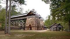
| 34 |
Tannehill Furnace |
|
000000001972-07-24-0000July 24, 1972
(#72000182) |
3 mi (4.8 km) east of U.S. Route 11
33°15′00″N 87°04′23″W / 33.25°N 87.073056°W / 33.25; -87.073056 (Tannehill Furnace) |
McCalla |
|
| 35 |
Tuscaloosa Veterans Administration Hospital Historic District |
|
000000002012-03-07-0000March 7, 2012
(#12000142) |
3701 Loop Rd., E.
33°11′29″N 87°29′09″W / 33.191384°N 87.485957°W / 33.191384; -87.485957 (Tuscaloosa Veterans Administration Hospital Historic District) |
Tuscaloosa |
part of the United States Second Generation Veterans Hospitals Multiple Property Submission
|
| 36 |
Wheeler House |
Upload image |
000000001980-04-28-0000April 28, 1980
(#80000737) |
2703 7th St.
33°12′23″N 87°34′18″W / 33.206389°N 87.571667°W / 33.206389; -87.571667 (Wheeler House) |
Tuscaloosa |
|
| 37 |
Wilson-Clements House |
|
000000001985-04-11-0000April 11, 1985
(#85000737) |
1802 20th Ave.
33°13′43″N 87°34′41″W / 33.228611°N 87.578056°W / 33.228611; -87.578056 (Wilson-Clements House) |
Northport |
|

.jpg)
.jpg)

.jpg)

.jpg)
.jpg)