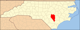
| [3] |
Name on the Register[4] |
Image |
Date listed[5] |
Location |
City or town |
Description |
|---|
| 1 |
Beatty-Corbett House |
Upload image |
000000001986-03-17-0000March 17, 1986
(#86000549) |
SR 701 at SR 1200
34°33′11″N 78°15′09″W / 34.553056°N 78.2525°W / 34.553056; -78.2525 (Beatty-Corbett House) |
Ivanhoe |
|
| 2 |
Bethune-Powell Buildings |
Upload image |
000000001986-03-17-0000March 17, 1986
(#86000580) |
118-120 E. Main St.
34°59′38″N 78°19′26″W / 34.993889°N 78.323889°W / 34.993889; -78.323889 (Bethune-Powell Buildings) |
Clinton |
|
| 3 |
Asher W. Bizzell House |
Upload image |
000000001986-05-21-0000May 21, 1986
(#86001125) |
US 13 and SR 1845
35°12′35″N 78°24′58″W / 35.209664°N 78.416231°W / 35.209664; -78.416231 (Asher W. Bizzell House) |
Rosin |
|
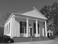
| 4 |
Black River Presbyterian and Ivanhoe Baptist Churches |
|
000000001986-03-17-0000March 17, 1986
(#86000550) |
SR 1102 E of SR 1100
34°36′12″N 78°14′25″W / 34.603333°N 78.240278°W / 34.603333; -78.240278 (Black River Presbyterian and Ivanhoe Baptist Churches) |
Ivanhoe |
|
| 5 |
Gen. Thomas Boykin House |
|
000000001986-03-17-0000March 17, 1986
(#86000551) |
SR 1214 SW of SR 1222
34°57′43″N 78°22′26″W / 34.961944°N 78.373889°W / 34.961944; -78.373889 (Gen. Thomas Boykin House) |
Clinton |
|
| 6 |
Thomas Bullard House |
Upload image |
000000002014-08-25-0000August 25, 2014
(#14000522) |
386 Carry Bridge Rd.
34°59′45″N 78°34′01″W / 34.9957°N 78.5669°W / 34.9957; -78.5669 (Thomas Bullard House) |
Autryville vicinity |
|
| 7 |
Marion Butler Birthplace |
Upload image |
000000001986-03-17-0000March 17, 1986
(#86000552) |
NC 242 at SR 1414
35°02′25″N 78°27′59″W / 35.040278°N 78.466389°W / 35.040278; -78.466389 (Marion Butler Birthplace) |
Salemburg |
|
| 8 |
Dan E. Caison, Sr., House |
Upload image |
000000001986-05-21-0000May 21, 1986
(#86001124) |
Broad St.
34°57′11″N 78°30′53″W / 34.953056°N 78.514722°W / 34.953056; -78.514722 (Dan E. Caison, Sr., House) |
Roseboro |
|
| 9 |
Cherrydale |
Upload image |
000000001986-03-17-0000March 17, 1986
(#86000554) |
SR 1919 at SR 1952
35°01′06″N 78°12′06″W / 35.018333°N 78.201667°W / 35.018333; -78.201667 (Cherrydale) |
Turkey |
|
| 10 |
Clear Run |
Upload image |
000000001986-03-17-0000March 17, 1986
(#86000548) |
NC 411 at Black River
34°44′23″N 78°15′56″W / 34.739722°N 78.265556°W / 34.739722; -78.265556 (Clear Run) |
Clear Run |
|
| 11 |
Clinton Commercial Historic District |
Upload image |
000000002002-05-30-0000May 30, 2002
(#02000568) |
Roughly bounded bu Vance, Elizabeth, Wall, and Sampson Sts.
34°59′51″N 78°19′28″W / 34.9975°N 78.324444°W / 34.9975; -78.324444 (Clinton Commercial Historic District) |
Clinton |
|
| 12 |
Clinton Depot |
Upload image |
000000001986-03-17-0000March 17, 1986
(#86000555) |
W. Elizabeth St.
34°59′38″N 78°19′24″W / 34.993889°N 78.323333°W / 34.993889; -78.323333 (Clinton Depot) |
Clinton |
|
| 13 |
College Street Historic District |
Upload image |
000000001986-03-17-0000March 17, 1986
(#86000553) |
600-802 College St.
34°59′54″N 78°18′49″W / 34.998333°N 78.313611°W / 34.998333; -78.313611 (College Street Historic District) |
Clinton |
|
| 14 |
Dell School Campus |
|
000000001986-05-21-0000May 21, 1986
(#86001126) |
US 421 and SR 1003
34°48′05″N 78°12′54″W / 34.801389°N 78.215°W / 34.801389; -78.215 (Dell School Campus) |
Delway |
|
| 15 |
Delta Farm |
Upload image |
000000001986-03-17-0000March 17, 1986
(#86000556) |
SR 1100 N of SR 1105
34°38′08″N 78°14′24″W / 34.635556°N 78.24°W / 34.635556; -78.24 (Delta Farm) |
Ivanhoe |
|
| 16 |
William E. Faison House |
Upload image |
000000002005-01-20-0000January 20, 2005
(#04001526) |
NC 50 at jct. with NC 1757 (10901 Suttontown Rd.)
35°09′32″N 78°10′18″W / 35.158889°N 78.171667°W / 35.158889; -78.171667 (William E. Faison House) |
Giddensville |
|
| 17 |
Graves-Stewart House |
Upload image |
000000001983-09-08-0000September 8, 1983
(#83001913) |
600 College St.
34°59′33″N 78°19′11″W / 34.9925°N 78.319722°W / 34.9925; -78.319722 (Graves-Stewart House) |
Clinton |
|
| 18 |
Robert Herring House |
Upload image |
000000001986-03-17-0000March 17, 1986
(#86000557) |
216 Sampson St.
35°00′03″N 78°19′29″W / 35.000833°N 78.324722°W / 35.000833; -78.324722 (Robert Herring House) |
Clinton |
|
| 19 |
Troy Herring House |
Upload image |
000000001986-03-17-0000March 17, 1986
(#86000558) |
Broad St. S of NC 24
34°57′25″N 78°31′00″W / 34.956944°N 78.516667°W / 34.956944; -78.516667 (Troy Herring House) |
Roseboro |
|
| 20 |
Lewis Highsmith Farm |
Upload image |
000000001986-03-17-0000March 17, 1986
(#86000559) |
US 421 S of NC 41
34°42′43″N 78°11′17″W / 34.711944°N 78.188056°W / 34.711944; -78.188056 (Lewis Highsmith Farm) |
Harrells |
|
| 21 |
Hollingsworth-Hines Farm |
Upload image |
000000001986-03-17-0000March 17, 1986
(#86000547) |
SR 1926 S of SR 1004
34°56′37″N 78°10′05″W / 34.943611°N 78.168056°W / 34.943611; -78.168056 (Hollingsworth-Hines Farm) |
Turkey |
|
| 22 |
Howard-Royal House |
Upload image |
000000001986-03-17-0000March 17, 1986
(#86000561) |
202 N. Main St.
35°00′58″N 78°30′12″W / 35.016111°N 78.503333°W / 35.016111; -78.503333 (Howard-Royal House) |
Salemburg |
|
| 23 |
Howell-Butler House |
Upload image |
000000001986-03-17-0000March 17, 1986
(#86000560) |
Broad and McLamb Sts.
34°57′02″N 78°30′49″W / 34.950556°N 78.513611°W / 34.950556; -78.513611 (Howell-Butler House) |
Roseboro |
|
| 24 |
Johnson Building |
Upload image |
000000002000-05-11-0000May 11, 2000
(#00000459) |
102-104 E. Main St.
34°59′51″N 78°19′27″W / 34.9975°N 78.324167°W / 34.9975; -78.324167 (Johnson Building) |
Clinton |
|
| 25 |
Samuel Johnson House and Cemetery |
Upload image |
000000001986-03-17-0000March 17, 1986
(#86000562) |
SR 1157 S of SR 1004
34°49′09″N 78°19′31″W / 34.819167°N 78.325278°W / 34.819167; -78.325278 (Samuel Johnson House and Cemetery) |
Ingold |
|
| 26 |
James Kerr House |
Upload image |
000000001986-03-17-0000March 17, 1986
(#86000563) |
SR 1005 S of SR 1007
34°39′03″N 78°15′31″W / 34.650833°N 78.258611°W / 34.650833; -78.258611 (James Kerr House) |
Kerr |
|
| 27 |
Marcheston Killett Farm |
Upload image |
000000001986-03-17-0000March 17, 1986
(#86000564) |
SR 1222 N of US 701
34°56′31″N 78°20′21″W / 34.941944°N 78.339167°W / 34.941944; -78.339167 (Marcheston Killett Farm) |
Clinton |
|
| 28 |
Marshall Kornegay House and Cemetery |
Upload image |
000000001986-03-17-0000March 17, 1986
(#86000565) |
SR 1725 and SR 1720
35°12′33″N 78°12′10″W / 35.209167°N 78.202778°W / 35.209167; -78.202778 (Marshall Kornegay House and Cemetery) |
Suttontown |
|
| 29 |
James H. Lamb House |
Upload image |
000000001986-03-17-0000March 17, 1986
(#86000566) |
SR 1135 N of NC 411
34°47′10″N 78°20′23″W / 34.786111°N 78.339722°W / 34.786111; -78.339722 (James H. Lamb House) |
Garland |
|
| 30 |
Lovett Lee House |
Upload image |
000000001986-03-17-0000March 17, 1986
(#86000567) |
SR 1725 and SR 1730
35°10′22″N 78°13′01″W / 35.172778°N 78.216944°W / 35.172778; -78.216944 (Lovett Lee House) |
Giddensville |
|
| 31 |
Dr. James O. Matthews Office |
Upload image |
000000001986-03-17-0000March 17, 1986
(#86000568) |
SR 1960 S of SR 1004
34°51′53″N 78°15′12″W / 34.864722°N 78.253333°W / 34.864722; -78.253333 (Dr. James O. Matthews Office) |
Taylors Bridge |
|
| 32 |
Fleet Matthis Farm |
Upload image |
000000001986-03-17-0000March 17, 1986
(#86000569) |
US 421 S of SR 1146
34°52′01″N 78°16′37″W / 34.866944°N 78.276944°W / 34.866944; -78.276944 (Fleet Matthis Farm) |
Taylors Bridge |
|
| 33 |
Jonas McPhail House and Annie McPhail Store |
Upload image |
000000001986-03-17-0000March 17, 1986
(#86000571) |
US 13 E of SR 1845
35°12′32″N 78°24′58″W / 35.208919°N 78.416028°W / 35.208919; -78.416028 (Jonas McPhail House and Annie McPhail Store) |
Rosin |
|
| 34 |
Murphy-Lamb House and Cemetery |
Upload image |
000000001986-03-17-0000March 17, 1986
(#86000570) |
SR 1135 S of US 701
34°47′46″N 78°21′36″W / 34.796111°N 78.36°W / 34.796111; -78.36 (Murphy-Lamb House and Cemetery) |
Garland |
|
| 35 |
Oak Plain Presbyterian Church |
Upload image |
000000001986-05-21-0000May 21, 1986
(#86001127) |
SR 1943 S of SR 1945
34°50′17″N 78°10′10″W / 34.838056°N 78.169444°W / 34.838056; -78.169444 (Oak Plain Presbyterian Church) |
Waycross |
|
| 36 |
Livingston Oates Farm |
Upload image |
000000001986-03-17-0000March 17, 1986
(#86000572) |
SR 1748 W of NC 403
35°04′12″N 78°15′28″W / 35.07°N 78.257778°W / 35.07; -78.257778 (Livingston Oates Farm) |
Clinton |
|
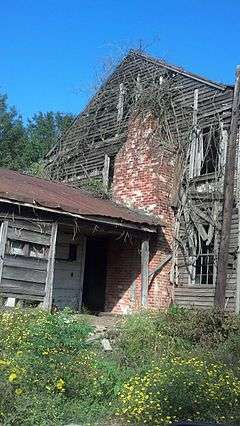
| 37 |
Owen Family House and Cemetery |
Upload image |
000000001986-03-17-0000March 17, 1986
(#86000573) |
SR 1212 N of SR 1214
34°53′44″N 78°27′02″W / 34.895556°N 78.450556°W / 34.895556; -78.450556 (Owen Family House and Cemetery) |
McDaniels |
Destroyed[6]
|
| 38 |
Patrick-Carr-Herring House |
Upload image |
000000001993-01-14-0000January 14, 1993
(#92001791) |
226 McKoy St.
35°00′02″N 78°19′41″W / 35.000556°N 78.328056°W / 35.000556; -78.328056 (Patrick-Carr-Herring House) |
Clinton |
|
| 39 |
Pigford House |
Upload image |
000000001986-03-17-0000March 17, 1986
(#86000574) |
SR 1751 S of US 701
35°02′40″N 78°19′29″W / 35.044444°N 78.324722°W / 35.044444; -78.324722 (Pigford House) |
Clinton |
|
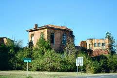
| 40 |
Pope House |
Upload image |
000000001986-03-17-0000March 17, 1986
(#86000575) |
SR 1146 N of SR 1145
34°54′51″N 78°18′30″W / 34.914167°N 78.308333°W / 34.914167; -78.308333 (Pope House) |
Clinton |
Burned[6]
|
| 41 |
Francis Pugh House |
Upload image |
000000001986-03-17-0000March 17, 1986
(#86000577) |
SR 1751 at NC 403
35°00′34″N 78°18′08″W / 35.009531°N 78.302147°W / 35.009531; -78.302147 (Francis Pugh House) |
Clinton |
|
| 42 |
Pugh-Boykin House |
Upload image |
000000001986-03-17-0000March 17, 1986
(#86000576) |
306 Elizabeth St.
34°59′39″N 78°19′32″W / 34.994167°N 78.325556°W / 34.994167; -78.325556 (Pugh-Boykin House) |
Clinton |
|
| 43 |
Royal-Crumpler-Parker House |
Upload image |
000000001986-03-17-0000March 17, 1986
(#86000578) |
512 Sunset Ave.
34°59′51″N 78°19′54″W / 34.9975°N 78.331667°W / 34.9975; -78.331667 (Royal-Crumpler-Parker House) |
Clinton |
|
| 44 |
Dr. John B. Seavey House and Cemetery |
Upload image |
000000001986-05-21-0000May 21, 1986
(#86001128) |
SR 1100 S of SR 1007
34°40′38″N 78°13′03″W / 34.677222°N 78.2175°W / 34.677222; -78.2175 (Dr. John B. Seavey House and Cemetery) |
Harrells |
|
| 45 |
Dr. David Dickson Sloan Farm |
Upload image |
000000001986-03-17-0000March 17, 1986
(#86000579) |
US 701 N of the South River
34°46′12″N 78°23′41″W / 34.77°N 78.394722°W / 34.77; -78.394722 (Dr. David Dickson Sloan Farm) |
Garland |
|
| 46 |
Thirteen Oaks |
Upload image |
000000001990-06-07-0000June 7, 1990
(#90000879) |
Jct. of US 13 and SR 1647
35°13′07″N 78°23′50″W / 35.218611°N 78.397222°W / 35.218611; -78.397222 (Thirteen Oaks) |
Newton Grove |
|
| 47 |
West Main-North Chesnutt Streets Historic District |
Upload image |
000000001986-03-17-0000March 17, 1986
(#86000546) |
Roughly N. Chesnutt, Fayetteville, and Williams Sts. between W. Main and Margaret Sts.
34°59′51″N 78°19′42″W / 34.9975°N 78.328333°W / 34.9975; -78.328333 (West Main-North Chesnutt Streets Historic District) |
Clinton |
|
| 48 |
Isaac Williams House |
Upload image |
000000001984-03-01-0000March 1, 1984
(#84002523) |
NC 55; also NC 55 at its junction with NC 50
35°14′52″N 78°22′55″W / 35.247778°N 78.381944°W / 35.247778; -78.381944 (Isaac Williams House) |
Newton Grove |
Second location represents a boundary increase of 000000001989-06-12-0000June 12, 1989
|
| 49 |
John E. Wilson House |
Upload image |
000000001986-03-17-0000March 17, 1986
(#86000545) |
SR 1631 at SR 1630
35°15′37″N 78°30′29″W / 35.260278°N 78.508056°W / 35.260278; -78.508056 (John E. Wilson House) |
Dunn |
|