| [3] |
Name on the Register[4] |
Image |
Date listed[5] |
Location |
City or town |
Description |
|---|
| 1 |
Academy Street Historic District |
Upload image |
000000001982-07-15-0000July 15, 1982
(#82003502) |
Academy St.
36°23′07″N 79°57′39″W / 36.385314°N 79.960919°W / 36.385314; -79.960919 (Academy Street Historic District) |
Madison |
|
| 2 |
Boone Road Historic District |
Upload image |
000000001987-08-31-0000August 31, 1987
(#87001455) |
Roughly 400 and 500 blks.of Boone Rd., 400 blk. of Chestnut and 500 blk. Glovenia Sts., and 200 blk. of Highland Dr.
36°29′48″N 79°45′40″W / 36.496667°N 79.761111°W / 36.496667; -79.761111 (Boone Road Historic District) |
Eden |
|
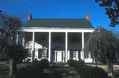
| 3 |
The Boxwoods |
Upload image |
000000001980-05-28-0000May 28, 1980
(#80002898) |
Penn Lane
36°22′55″N 79°57′46″W / 36.381944°N 79.962778°W / 36.381944; -79.962778 (The Boxwoods) |
Madison |
|
| 4 |
Bullard-Ray House |
Upload image |
000000001982-06-11-0000June 11, 1982
(#82003501) |
650 Washington St.
36°29′25″N 79°45′51″W / 36.490278°N 79.764167°W / 36.490278; -79.764167 (Bullard-Ray House) |
Eden |
|
| 5 |
Cascade Plantation |
Upload image |
000000001975-10-14-0000October 14, 1975
(#75001288) |
NE of Eden off NC 770
36°31′22″N 79°39′29″W / 36.522778°N 79.658056°W / 36.522778; -79.658056 (Cascade Plantation) |
Eden |
|
| 6 |
Central Leaksville Historic District |
Upload image |
000000001986-12-09-0000December 9, 1986
(#86003376) |
Roughly bounded by Lindsay, Monroe, Jay, Washington, & Kemp Sts.
36°29′31″N 79°46′05″W / 36.491944°N 79.768056°W / 36.491944; -79.768056 (Central Leaksville Historic District) |
Eden |
|
| 7 |
Chinqua-Penn Plantation |
|
000000001993-04-08-0000April 8, 1993
(#93000235) |
NC 1998 N side, 0.2 miles W of jct. with NC 1987
36°23′04″N 79°42′00″W / 36.384444°N 79.7°W / 36.384444; -79.7 (Chinqua-Penn Plantation) |
Reidsville |
|
| 8 |
Cross Rock Rapid Sluice |
Upload image |
000000001984-03-19-0000March 19, 1984
(#84002459) |
Address Restricted
|
Madison |
|
| 9 |
Dead Timber Ford Sluices |
Upload image |
000000001984-06-29-0000June 29, 1984
(#84002455) |
Address Restricted
|
Wentworth |
|
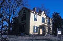
| 10 |
Dempsey-Reynolds-Taylor House |
Upload image |
000000001983-09-08-0000September 8, 1983
(#83001910) |
610 Henry St.
36°29′29″N 79°45′57″W / 36.491389°N 79.765833°W / 36.491389; -79.765833 (Dempsey-Reynolds-Taylor House) |
Eden |
|
| 11 |
Eagle Falls Sluice |
Upload image |
000000001984-03-19-0000March 19, 1984
(#84002462) |
Address Restricted
|
Wentworth |
|
| 12 |
Fewell-Reynolds House |
Upload image |
000000001979-07-16-0000July 16, 1979
(#79003349) |
Address Restricted
|
Madison |
|
| 13 |
First Baptist Church |
Upload image |
000000001989-03-22-0000March 22, 1989
(#89000178) |
538 Greenwood St.
36°29′43″N 79°45′50″W / 36.495278°N 79.763889°W / 36.495278; -79.763889 (First Baptist Church) |
Eden |
|
| 14 |
First Baptist Church |
Upload image |
000000001986-12-11-0000December 11, 1986
(#86003386) |
401 S. Scales St.
36°21′26″N 79°39′52″W / 36.357222°N 79.664444°W / 36.357222; -79.664444 (First Baptist Church) |
Reidsville |
|
| 15 |
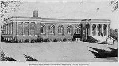
Former Reidsville High School |
|
000000001994-01-21-0000January 21, 1994
(#93001540) |
116 N. Franklin St.
36°21′46″N 79°40′14″W / 36.362778°N 79.670556°W / 36.362778; -79.670556 (Former Reidsville High School) |
Reidsville |
|
| 16 |
Gravel Shoals Sluice |
Upload image |
000000001984-03-19-0000March 19, 1984
(#84002458) |
Address Restricted
|
Madison |
|
| 17 |
High Rock Farm |
Upload image |
000000001974-04-26-0000April 26, 1974
(#74001373) |
SE of Reidsville on SR 2619
36°15′36″N 79°34′00″W / 36.26°N 79.566667°W / 36.26; -79.566667 (High Rock Farm) |
Williamsburg |
|
| 18 |
Jacob's Creek Landing |
Upload image |
000000001984-03-19-0000March 19, 1984
(#84002522) |
Address Restricted
|
Madison |
|
| 19 |
Jennings-Baker House |
Upload image |
000000001987-03-12-0000March 12, 1987
(#86003387) |
608 Vance St.
36°21′19″N 79°40′42″W / 36.355278°N 79.678333°W / 36.355278; -79.678333 (Jennings-Baker House) |
Reidsville |
|
| 20 |
Dr. Franklin King House-Idlewild |
Upload image |
000000001985-09-19-0000September 19, 1985
(#85002415) |
700 blk. of Bridge St.
36°29′26″N 79°45′40″W / 36.490556°N 79.761111°W / 36.490556; -79.761111 (Dr. Franklin King House-Idlewild) |
Eden |
|
| 21 |
Leaksville Commercial Historic District |
Upload image |
000000001987-10-23-0000October 23, 1987
(#87001422) |
622-656 Washington & 634 Monroe Sts.
36°29′25″N 79°45′51″W / 36.490278°N 79.764167°W / 36.490278; -79.764167 (Leaksville Commercial Historic District) |
Eden |
|
| 22 |
Leaksville-Spray Institute |
Upload image |
000000001989-03-09-0000March 9, 1989
(#89000179) |
609 College St.
36°29′35″N 79°45′34″W / 36.493056°N 79.759444°W / 36.493056; -79.759444 (Leaksville-Spray Institute) |
Eden |
|
| 23 |
Lower Sauratown Plantation |
Upload image |
000000001984-10-11-0000October 11, 1984
(#84000071) |
Address Restricted
|
Eden |
|
| 24 |
Mayo River Sluice |
Upload image |
000000001984-03-19-0000March 19, 1984
(#84002466) |
Address Restricted
|
Madison |
|
| 25 |
Mayodan Historic District |
Upload image |
000000002016-08-15-0000August 15, 2016
(#16000222) |
Roughly bounded by West Adams St., North and South Second Ave., and North and South Third Ave.
36°24′45″N 79°58′02″W / 36.412618°N 79.967296°W / 36.412618; -79.967296 (Mayodan Historic District) |
Mayodan |
|
| 26 |
Reuben Wallace McCollum House |
Upload image |
000000002003-05-01-0000May 1, 2003
(#03000341) |
2203 S. Scales St.
36°18′52″N 79°40′13″W / 36.314444°N 79.670278°W / 36.314444; -79.670278 (Reuben Wallace McCollum House) |
Reidsville |
|
| 27 |
Mt. Sinai Baptist Church |
Upload image |
000000001987-06-25-0000June 25, 1987
(#87000914) |
512 Henry St.
36°29′38″N 79°46′07″W / 36.493889°N 79.768611°W / 36.493889; -79.768611 (Mt. Sinai Baptist Church) |
Eden |
|
| 28 |
North Washington Avenue Workers' House |
Upload image |
000000001986-12-11-0000December 11, 1986
(#86003388) |
Eastern side of the 300 block of N. Washington Ave.
36°21′55″N 79°40′17″W / 36.365278°N 79.671389°W / 36.365278; -79.671389 (North Washington Avenue Workers' House) |
Reidsville |
|
| 29 |
Penn House |
|
000000001983-11-25-0000November 25, 1983
(#83003992) |
324 Maple Ave.
36°21′27″N 79°40′09″W / 36.3575°N 79.669167°W / 36.3575; -79.669167 (Penn House) |
Reidsville |
|
| 30 |
Gov. David S. Reid House |
|
000000001974-04-26-0000April 26, 1974
(#74001374) |
219 SE Market St.
36°21′36″N 79°39′46″W / 36.360089°N 79.662833°W / 36.360089; -79.662833 (Gov. David S. Reid House) |
Reidsville |
|
| 31 |
Reidsville Historic District |
Upload image |
000000001987-03-12-0000March 12, 1987
(#86003391) |
Roughly bounded by W. Morehead, Southern Railway tracks, Lawson Ave., Main, Piedmontg, Vance and Lindsey Sts.
36°21′23″N 79°40′00″W / 36.356389°N 79.666667°W / 36.356389; -79.666667 (Reidsville Historic District) |
Reidsville |
|
| 32 |
Richardson Houses Historic District |
Upload image |
000000001986-12-11-0000December 11, 1986
(#86003390) |
NW side of Richardson Dr. between Coach Rd. and Woodland Dr.
36°20′31″N 79°40′58″W / 36.341944°N 79.682778°W / 36.341944; -79.682778 (Richardson Houses Historic District) |
Reidsville |
|
| 33 |
Roberson's Fish Trap Shoal Sluice |
Upload image |
000000001984-03-19-0000March 19, 1984
(#84002468) |
Address Restricted
|
Madison |
|
| 34 |
Rockingham County Courthouse |
|
000000001979-05-10-0000May 10, 1979
(#79001748) |
Highway 65
36°23′52″N 79°46′16″W / 36.397883°N 79.771161°W / 36.397883; -79.771161 (Rockingham County Courthouse) |
Wentworth |
|
| 35 |
Alfred Moore Scales Law Office |
Upload image |
000000001982-04-29-0000April 29, 1982
(#82003503) |
307 Carter St.
36°23′23″N 79°57′52″W / 36.389675°N 79.964506°W / 36.389675; -79.964506 (Alfred Moore Scales Law Office) |
Madison |
|
| 36 |
Site 31RK1 |
Upload image |
000000001984-05-24-0000May 24, 1984
(#84002474) |
Southern side of the Dan River, southeast of Eden[6]
36°29′23″N 79°42′39″W / 36.489722°N 79.710833°W / 36.489722; -79.710833 (Site 31RK1) |
Eden |
|
| 37 |
Slink Shoal Sluice and Wing Dams |
Upload image |
000000001984-03-19-0000March 19, 1984
(#84002475) |
Address Restricted
|
Madison |
|
| 38 |
Spray Industrial Historic District |
Upload image |
000000001986-12-09-0000December 9, 1986
(#86003371) |
Roughly bounded by Warehouse, Rhode Island, River Dr., Washburn Rd., the Smith River, E. Early Ave., and Church
36°30′39″N 79°45′22″W / 36.510833°N 79.756111°W / 36.510833; -79.756111 (Spray Industrial Historic District) |
Eden |
|
| 39 |
St. Luke's Episcopal Church |
Upload image |
000000001989-03-17-0000March 17, 1989
(#89000177) |
604 Morgan Rd.
36°31′01″N 79°45′39″W / 36.516944°N 79.760833°W / 36.516944; -79.760833 (St. Luke's Episcopal Church) |
Eden |
|
| 40 |
Tanyard Shoal Sluice |
Upload image |
000000001984-03-19-0000March 19, 1984
(#84002478) |
Address Restricted
|
Eden |
|
| 41 |
Three Ledges Shoal Sluice |
Upload image |
000000001984-03-19-0000March 19, 1984
(#84002481) |
Address Restricted
|
Eden |
|
| 42 |
Troublesome Creek Ironworks |
Upload image |
000000001972-09-29-0000September 29, 1972
(#72000989) |
Address Restricted
|
Monroeton |
|
| 43 |
Washington Mills-Mayodan Plant |
Upload image |
000000002005-04-20-0000April 20, 2005
(#05000319) |
7801 NC 35
36°24′32″N 79°57′57″W / 36.408889°N 79.965833°W / 36.408889; -79.965833 (Washington Mills-Mayodan Plant) |
Mayodan |
|
| 44 |
Wentworth Methodist Episcopal Church and Cemetery |
Upload image |
000000001986-03-13-0000March 13, 1986
(#86000391) |
NC 65 W of SR 2124
36°24′03″N 79°46′40″W / 36.400833°N 79.777778°W / 36.400833; -79.777778 (Wentworth Methodist Episcopal Church and Cemetery) |
Wentworth |
|
| 45 |
Wide Mouth Shoal Sluice |
Upload image |
000000001984-03-19-0000March 19, 1984
(#84002484) |
Address Restricted
|
Eden |
|
| 46 |
Wright Tavern |
|
000000001970-09-15-0000September 15, 1970
(#70000467) |
NC 65
36°23′54″N 79°46′13″W / 36.398333°N 79.770278°W / 36.398333; -79.770278 (Wright Tavern) |
Wentworth |
|