| [3] |
Name on the Register[4] |
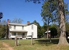
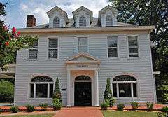
Image |
Date listed[5] |
Location |
City or town |
Description |
|---|
| 1 |
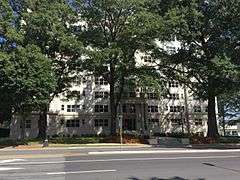
Addison Apartments |
|
000000001990-08-23-0000August 23, 1990
(#90001314) |
831 E. Morehead St.
35°12′50″N 80°50′41″W / 35.213889°N 80.844722°W / 35.213889; -80.844722 (Addison Apartments) |
Charlotte |
|
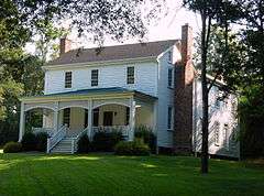
| 2 |
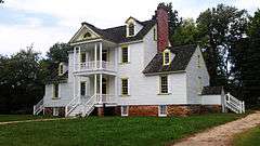
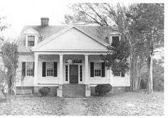
Hezekiah Alexander House |
|
000000001970-04-17-0000April 17, 1970
(#70000461) |
3500 Shamrock Dr.
35°13′55″N 80°46′00″W / 35.231944°N 80.766667°W / 35.231944; -80.766667 (Hezekiah Alexander House) |
Charlotte |
|
| 3 |
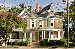
Neal Somers Alexander House |
|
000000002008-05-07-0000May 7, 2008
(#08000381) |
5014 N. Sharon Amity Rd.
35°13′38″N 80°44′49″W / 35.227136°N 80.746847°W / 35.227136; -80.746847 (Neal Somers Alexander House) |
Charlotte |
|
| 4 |
William T. Alexander House |
Upload image |
000000002003-01-15-0000January 15, 2003
(#02001718) |
Mallard Cr. Church Rd., .1 mi W. of Jct. with US 29
35°19′23″N 80°44′05″W / 35.323056°N 80.734722°W / 35.323056; -80.734722 (William T. Alexander House) |
Charlotte |
|
| 5 |
Barringer Hotel |
|
000000002011-08-29-0000August 29, 2011
(#11000637) |
426 N. Tryon St.
35°13′48″N 80°50′19″W / 35.23°N 80.838611°W / 35.23; -80.838611 (Barringer Hotel) |
Charlotte |
|
| 6 |
Beaver Dam Plantation House |
|
000000001979-03-19-0000March 19, 1979
(#79001735) |
SE of Davidson on NC 73
35°28′32″N 80°49′04″W / 35.475556°N 80.817778°W / 35.475556; -80.817778 (Beaver Dam Plantation House) |
Davidson |
|
| 7 |
Biddle Memorial Hall, Johnson C. Smith University |
|
000000001975-10-14-0000October 14, 1975
(#75001281) |
Beatties Ford Rd. and W. Trade St.
35°14′36″N 80°51′26″W / 35.243333°N 80.857222°W / 35.243333; -80.857222 (Biddle Memorial Hall, Johnson C. Smith University) |
Charlotte |
|
| 8 |
Billingsville School |
Upload image |
000000001999-11-12-0000November 12, 1999
(#99001366) |
3100 Leroy St.
35°11′46″N 80°48′30″W / 35.196111°N 80.808333°W / 35.196111; -80.808333 (Billingsville School) |
Charlotte |
|
| 9 |
Chairman Blake House |
|
000000002004-08-25-0000August 25, 2004
(#04000905) |
318 Chairman Blake Ln.
35°29′52″N 80°50′54″W / 35.497778°N 80.848333°W / 35.497778; -80.848333 (Chairman Blake House) |
Davidson |
|
| 10 |
James A. Blakeney House |
Upload image |
000000001998-06-18-0000June 18, 1998
(#98000706) |
West side NC 3629, .5 mi S of jct NC 3626
35°02′24″N 80°49′05″W / 35.04°N 80.818056°W / 35.04; -80.818056 (James A. Blakeney House) |
Providence |
|
| 11 |
Philip Carey Building |
|
000000001984-03-01-0000March 1, 1984
(#84002408) |
301 E. 7th St.
35°13′39″N 80°50′23″W / 35.2275°N 80.839722°W / 35.2275; -80.839722 (Philip Carey Building) |
Charlotte |
|
| 12 |
Carolina School Supply Company Building (Former) |
|
000000002001-04-12-0000April 12, 2001
(#01000374) |
1023 W. Morehead St.
35°13′41″N 80°51′38″W / 35.228056°N 80.860556°W / 35.228056; -80.860556 (Carolina School Supply Company Building (Former)) |
Charlotte |
|
| 13 |
Carolina Transfer and Storage Company Building, (Former) |
|
000000001999-11-30-0000November 30, 1999
(#99001447) |
1230 W. Morehead St.
35°13′44″N 80°51′42″W / 35.228889°N 80.861667°W / 35.228889; -80.861667 (Carolina Transfer and Storage Company Building, (Former)) |
Charlotte |
|
| 14 |
John Price Carr House |
|
000000001980-10-22-0000October 22, 1980
(#80002885) |
200-206 N. McDowell St.
35°13′16″N 80°50′00″W / 35.221111°N 80.833333°W / 35.221111; -80.833333 (John Price Carr House) |
Charlotte |
|
| 15 |
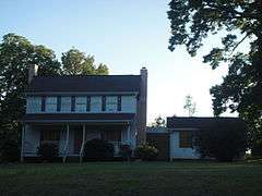
Cedar Grove |
Upload image |
000000001972-02-01-0000February 1, 1972
(#72000976) |
3 miles W of Huntersville off U.S. 21
35°23′40″N 80°53′55″W / 35.394444°N 80.898611°W / 35.394444; -80.898611 (Cedar Grove) |
Huntersville |
|
| 16 |
Charlotte Supply Company Building |
Upload image |
000000001984-03-01-0000March 1, 1984
(#84002348) |
500 S. Mint St.
35°13′35″N 80°51′02″W / 35.226389°N 80.850556°W / 35.226389; -80.850556 (Charlotte Supply Company Building) |
Charlotte |
Demolished June 1991[6]
|
| 17 |
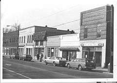
Commercial Building at 500 North Tryon Street |
Upload image |
000000001992-11-20-0000November 20, 1992
(#92001615) |
500 N. Tryon St.
35°13′48″N 80°50′18″W / 35.23°N 80.838333°W / 35.23; -80.838333 (Commercial Building at 500 North Tryon Street) |
Charlotte |
|
| 18 |
Crane Company Building (Former) |
|
000000002001-05-08-0000May 8, 2001
(#01000423) |
1307 W. Morehead St.
35°13′42″N 80°51′50″W / 35.228333°N 80.863889°W / 35.228333; -80.863889 (Crane Company Building (Former)) |
Charlotte |
|
| 19 |
Dr. Walter Pharr Craven House |
Upload image |
000000001991-01-31-0000January 31, 1991
(#90002187) |
7648 Mt. Holly-Huntersville Rd.
35°20′47″N 80°53′47″W / 35.346389°N 80.896389°W / 35.346389; -80.896389 (Dr. Walter Pharr Craven House) |
Charlotte |
|
| 20 |
Croft Historic District |
Upload image |
000000001999-06-10-0000June 10, 1999
(#99000699) |
Jct. of NC 115 and NC 2483
35°20′44″N 80°49′23″W / 35.345556°N 80.823056°W / 35.345556; -80.823056 (Croft Historic District) |
Charlotte |
|
| 21 |
Benjamin W. Davidson House |
Upload image |
000000001976-04-26-0000April 26, 1976
(#76001331) |
W of Huntersville on SR 2138
35°23′45″N 80°52′34″W / 35.395833°N 80.876111°W / 35.395833; -80.876111 (Benjamin W. Davidson House) |
Huntersville |
|
| 22 |
Davidson Historic District |
|
000000002009-06-01-0000June 1, 2009
(#09000381) |
Bounded by N. Main and Beaty Sts., Catawba Ave., Mocks and Concord Rds., Pat Stough and Dogwood Lns., Davidson College
35°29′58″N 80°50′55″W / 35.499444°N 80.848611°W / 35.499444; -80.848611 (Davidson Historic District) |
Davidson |
|
| 23 |
Dilworth Historic District |
Upload image |
000000001987-04-09-0000April 9, 1987
(#87000610) |
Roughly bounded by Myrtle, Morehead, Berkeley, Dilworth Rd. W, Charlotte, Park, Tremont, Cleveland and Renssalaer; also the eastern side of the 2000 block of Euclid Ave. and both sides of the 2000 block of Lyndhurst Ave.
35°12′28″N 80°51′00″W / 35.207778°N 80.85°W / 35.207778; -80.85 (Dilworth Historic District) |
Charlotte |
Second set of boundaries represents a boundary increase of 000000002000-12-07-0000December 7, 2000
|
| 24 |
James Buchanan Duke House |
|
000000001978-01-20-0000January 20, 1978
(#78001963) |
400 Hermitage Rd.
35°12′05″N 80°49′39″W / 35.201389°N 80.8275°W / 35.201389; -80.8275 (James Buchanan Duke House) |
Charlotte |
|
| 25 |
East Avenue Tabernacle Associate Reformed Presbyterian Church |
|
000000002005-01-20-0000January 20, 2005
(#04001523) |
927 Elizabeth St.
35°13′10″N 80°50′04″W / 35.219444°N 80.834444°W / 35.219444; -80.834444 (East Avenue Tabernacle Associate Reformed Presbyterian Church) |
Charlotte |
|
| 26 |
Elizabeth Historic District |
Upload image |
000000001989-01-03-0000January 3, 1989
(#88003003) |
Roughly bounded by Central Ave., Seaboard Coast Line Railroad, E. 5th St., Kenmore Ave., Park Dr., and E. Independence
35°12′51″N 80°49′05″W / 35.214167°N 80.818056°W / 35.214167; -80.818056 (Elizabeth Historic District) |
Charlotte |
|
| 27 |
Eumenean Hall, Davidson College |
|
000000001972-04-13-0000April 13, 1972
(#72000974) |
Davidson College campus
35°30′00″N 80°50′51″W / 35.5°N 80.8475°W / 35.5; -80.8475 (Eumenean Hall, Davidson College) |
Davidson |
|
| 28 |
John F. Ewart Farm |
Upload image |
000000001991-02-04-0000February 4, 1991
(#91000023) |
12920 Huntersville-Concord Rd.
35°24′45″N 80°49′26″W / 35.4125°N 80.823889°W / 35.4125; -80.823889 (John F. Ewart Farm) |
Huntersville |
|
| 29 |
Fire Station No. 2 |
|
000000001980-10-22-0000October 22, 1980
(#80002886) |
1212 South Blvd.
35°13′01″N 80°51′06″W / 35.216879°N 80.85156°W / 35.216879; -80.85156 (Fire Station No. 2) |
Charlotte |
|
| 30 |
First Presbyterian Church |
|
000000001982-11-12-0000November 12, 1982
(#82001300) |
200 W. Trade St.
35°13′44″N 80°50′38″W / 35.228889°N 80.843889°W / 35.228889; -80.843889 (First Presbyterian Church) |
Charlotte |
|
| 31 |
Former Charlotte Coca-Cola Bottling Company Plant |
|
000000001998-02-26-0000February 26, 1998
(#98000157) |
1401–1409 W. Morehead St.
35°13′43″N 80°51′52″W / 35.228611°N 80.864444°W / 35.228611; -80.864444 (Former Charlotte Coca-Cola Bottling Company Plant) |
Charlotte |
|
| 32 |
Former Nebel Knitting Mill |
|
000000001991-09-05-0000September 5, 1991
(#91001376) |
101 W. Worthington Ave.
35°12′41″N 80°51′38″W / 35.211389°N 80.860556°W / 35.211389; -80.860556 (Former Nebel Knitting Mill) |
Charlotte |
|
| 33 |
Former Parks-Cramer Company Complex |
|
000000001994-03-07-0000March 7, 1994
(#94000146) |
2000 South Blvd.
35°12′35″N 80°51′40″W / 35.209722°N 80.861111°W / 35.209722; -80.861111 (Former Parks-Cramer Company Complex) |
Charlotte |
|
| 34 |
Former Thrift Mill |
|
000000001994-08-26-0000August 26, 1994
(#94001049) |
8300 Moore's Chapel Rd.
35°16′37″N 80°56′40″W / 35.276944°N 80.944444°W / 35.276944; -80.944444 (Former Thrift Mill) |
Charlotte |
|
| 35 |
Former Daniel A. Tompkins Company Machine Shop |
|
000000002001-05-08-0000May 8, 2001
(#01000422) |
1900 South Boulevard
35°12′39″N 80°51′36″W / 35.210833°N 80.86°W / 35.210833; -80.86 (Former Daniel A. Tompkins Company Machine Shop) |
Charlotte |
|
| 36 |
Frederick Apartments |
|
000000002001-04-05-0000April 5, 2001
(#01000341) |
515 N. Church St.
35°13′54″N 80°50′22″W / 35.231667°N 80.839444°W / 35.231667; -80.839444 (Frederick Apartments) |
Charlotte |
|
| 37 |
Thomas and Latitia Gluyas House |
Upload image |
000000002001-07-11-0000July 11, 2001
(#01000725) |
7314 Mount Holly-Huntersville Rd.
35°20′39″N 80°54′03″W / 35.344167°N 80.900833°W / 35.344167; -80.900833 (Thomas and Latitia Gluyas House) |
Huntersville |
|
| 38 |
Grace A.M.E. Zion Church |
|
000000002008-05-15-0000May 15, 2008
(#08000412) |
219-223 S. Brevard St.
35°13′24″N 80°50′31″W / 35.223236°N 80.841908°W / 35.223236; -80.841908 (Grace A.M.E. Zion Church) |
Charlotte |
|
| 39 |
Sidney and Ethel Grier House |
Upload image |
000000002006-08-23-0000August 23, 2006
(#06000724) |
4747 Grier Farm Ln.
35°03′44″N 80°45′44″W / 35.062222°N 80.762222°W / 35.062222; -80.762222 (Sidney and Ethel Grier House) |
Charlotte |
|
| 40 |
Grier-Rea House |
|
000000002010-08-30-0000August 30, 2010
(#10000603) |
6701 Providence Rd.
35°07′02″N 80°46′46″W / 35.117222°N 80.779444°W / 35.117222; -80.779444 (Grier-Rea House) |
Charlotte |
|
| 41 |
Grinnell Company-General Fire Extinguisher Company Complex |
|
000000002003-12-10-0000December 10, 2003
(#03001275) |
1431 W. Morehead St.
35°13′42″N 80°52′00″W / 35.228333°N 80.866667°W / 35.228333; -80.866667 (Grinnell Company-General Fire Extinguisher Company Complex) |
Charlotte |
|
| 42 |
Hayes-Byrum Store and House |
|
000000001991-01-31-0000January 31, 1991
(#90002186) |
NC 160 S of jct. with Shopton Rd.
35°10′12″N 80°57′48″W / 35.17°N 80.963333°W / 35.17; -80.963333 (Hayes-Byrum Store and House) |
Charlotte |
|
| 43 |
Highland Park Manufacturing Company Mill No. 3 |
|
000000001988-10-20-0000October 20, 1988
(#88001855) |
2901 N. Davidson St.
35°14′44″N 80°48′35″W / 35.245556°N 80.809722°W / 35.245556; -80.809722 (Highland Park Manufacturing Company Mill No. 3) |
Charlotte |
|
| 44 |
Eugene Wilson Hodges Farm |
Upload image |
000000001991-02-21-0000February 21, 1991
(#91000077) |
2900 Rocky River Church Rd.
35°16′21″N 80°42′17″W / 35.2725°N 80.704722°W / 35.2725; -80.704722 (Eugene Wilson Hodges Farm) |
Charlotte |
|
| 45 |
Holly Bend |
Upload image |
000000001972-03-24-0000March 24, 1972
(#72000977) |
W of Huntersville on SR 2720
35°23′03″N 80°57′51″W / 35.384167°N 80.964167°W / 35.384167; -80.964167 (Holly Bend) |
Huntersville |
|
| 46 |
Home Federal Building |
Upload image |
000000002008-01-30-0000January 30, 2008
(#07001499) |
139 S. Tryon St.
35°13′35″N 80°50′37″W / 35.226389°N 80.843611°W / 35.226389; -80.843611 (Home Federal Building) |
Charlotte |
Replaced by a condo
|
| 47 |
Hopewell Presbyterian Church and Cemetery |
|
000000001996-03-01-0000March 1, 1996
(#96000198) |
10500 Beatties Ford Rd.
35°21′55″N 80°53′54″W / 35.365278°N 80.898333°W / 35.365278; -80.898333 (Hopewell Presbyterian Church and Cemetery) |
Huntersville |
|
| 48 |
Hoskins Mill |
Upload image |
000000001988-10-05-0000October 5, 1988
(#88001702) |
201 S. Hoskins Rd.
35°15′49″N 80°53′11″W / 35.263611°N 80.886389°W / 35.263611; -80.886389 (Hoskins Mill) |
Charlotte |
|
| 49 |
Huntersville Colored High School |
Upload image |
000000002009-08-20-0000August 20, 2009
(#09000636) |
302 Holbrooks Rd.
35°23′54″N 80°50′09″W / 35.398333°N 80.835833°W / 35.398333; -80.835833 (Huntersville Colored High School) |
Huntersville |
|
| 50 |
Hotel Charlotte |
|
000000001979-07-02-0000July 2, 1979
(#79003344) |
327 W. Trade St.
35°13′43″N 80°50′44″W / 35.228611°N 80.845556°W / 35.228611; -80.845556 (Hotel Charlotte) |
Charlotte |
Demolished November 6, 1988[6]
|
| 51 |
Independence Building |
Upload image |
000000001978-09-18-0000September 18, 1978
(#78001964) |
100-102 W. Trade St.
35°13′39″N 80°50′35″W / 35.2275°N 80.843056°W / 35.2275; -80.843056 (Independence Building) |
Charlotte |
Demolished September 1981[6]
|
| 52 |
Charles R. Jonas Federal Building |
|
000000001978-06-07-0000June 7, 1978
(#78001965) |
401 W. Trade St.
35°13′49″N 80°50′49″W / 35.230278°N 80.846944°W / 35.230278; -80.846944 (Charles R. Jonas Federal Building) |
Charlotte |
|
| 53 |
Hamilton C. Jones III House |
Upload image |
000000002002-05-02-0000May 2, 2002
(#02000439) |
201 Cherokee Rd.
35°12′05″N 80°49′18″W / 35.201389°N 80.821667°W / 35.201389; -80.821667 (Hamilton C. Jones III House) |
Charlotte |
|
| 54 |
Bishop John C. Kilgo House |
|
000000002009-01-22-0000January 22, 2009
(#08001364) |
2100 The Plaza
35°13′49″N 80°48′29″W / 35.230208°N 80.807958°W / 35.230208; -80.807958 (Bishop John C. Kilgo House) |
Charlotte |
|
| 55 |
Latta Arcade |
|
000000001975-10-29-0000October 29, 1975
(#75001282) |
320 S. Tryon St.
35°13′32″N 80°50′45″W / 35.225556°N 80.845833°W / 35.225556; -80.845833 (Latta Arcade) |
Charlotte |
An indoor shopping arcade with a glass skylight
|
| 56 |
Latta House |
|
000000001972-03-16-0000March 16, 1972
(#72000978) |
6 miles S of Huntersville on SR 2125
35°21′16″N 80°55′53″W / 35.354444°N 80.931389°W / 35.354444; -80.931389 (Latta House) |
Huntersville |
|
| 57 |
Elizabeth Lawrence House and Garden |
Upload image |
000000002006-09-14-0000September 14, 2006
(#06000866) |
348 Ridgewood Ave.
35°10′48″N 80°50′36″W / 35.179867°N 80.843419°W / 35.179867; -80.843419 (Elizabeth Lawrence House and Garden) |
Charlotte |
|
| 58 |
Liddell-McNinch House |
|
000000001976-12-12-0000December 12, 1976
(#76001330) |
511 N. Church St.
35°13′53″N 80°50′23″W / 35.231389°N 80.839722°W / 35.231389; -80.839722 (Liddell-McNinch House) |
Charlotte |
|
| 59 |
Louise Cotton Mill |
Upload image |
000000002013-12-31-0000December 31, 2013
(#13001027) |
1101 Hawthorne Ln.
35°13′29″N 80°49′06″W / 35.2247451°N 80.8184123°W / 35.2247451; -80.8184123 (Louise Cotton Mill) |
Charlotte |
|
| 60 |
Matthews Commercial Historic District |
|
000000001996-08-22-0000August 22, 1996
(#96000928) |
157-195 and 156-196 N. Trade St., 118 E. Charles St.
35°06′59″N 80°43′20″W / 35.116389°N 80.722222°W / 35.116389; -80.722222 (Matthews Commercial Historic District) |
Matthews |
|
| 61 |
Mayes House |
|
000000001993-08-05-0000August 5, 1993
(#93000735) |
435 E. Morehead St.
35°11′26″N 80°50′54″W / 35.190556°N 80.848333°W / 35.190556; -80.848333 (Mayes House) |
Charlotte |
|
| 62 |
Albert McCoy Farm |
|
000000002000-11-02-0000November 2, 2000
(#00001291) |
10401 McCoy Rd.
35°22′01″N 80°53′10″W / 35.366944°N 80.886111°W / 35.366944; -80.886111 (Albert McCoy Farm) |
Huntersville |
|
| 63 |
Samuel J. McElroy House |
|
000000001991-02-21-0000February 21, 1991
(#91000078) |
10915 Beatties Ford Rd.
35°22′11″N 80°54′09″W / 35.369722°N 80.9025°W / 35.369722; -80.9025 (Samuel J. McElroy House) |
Huntersville |
|
| 64 |
John Washington McKinney House |
Upload image |
000000001991-02-21-0000February 21, 1991
(#91000079) |
7332 Providence Rd. W.
35°03′39″N 80°48′17″W / 35.060833°N 80.804722°W / 35.060833; -80.804722 (John Washington McKinney House) |
Charlotte |
Destroyed[6]
|
| 65 |
Frank Ramsay McNinch House |
Upload image |
000000001999-06-03-0000June 3, 1999
(#99000670) |
2727 Sharon Ln.
35°09′39″N 80°49′09″W / 35.160833°N 80.819167°W / 35.160833; -80.819167 (Frank Ramsay McNinch House) |
Charlotte |
|
| 66 |
Mecklenburg County Courthouse |
|
000000001979-05-10-0000May 10, 1979
(#79001734) |
E. Trade, Alexander, and E. 4th Sts.
35°13′16″N 80°50′15″W / 35.221111°N 80.8375°W / 35.221111; -80.8375 (Mecklenburg County Courthouse) |
Charlotte |
|
| 67 |
Mecklenburg Investment Company Building |
|
000000001982-08-19-0000August 19, 1982
(#82003486) |
233 S. Brevard St.
35°13′22″N 80°50′32″W / 35.222778°N 80.842222°W / 35.222778; -80.842222 (Mecklenburg Investment Company Building) |
Charlotte |
|
| 68 |
Merchants and Farmers National Bank Building |
Upload image |
000000001984-03-01-0000March 1, 1984
(#84002344) |
123 E. Trade St.
35°13′36″N 80°50′32″W / 35.226667°N 80.842222°W / 35.226667; -80.842222 (Merchants and Farmers National Bank Building) |
Charlotte |
|
| 69 |
Green Morris Farm |
Upload image |
000000001991-02-21-0000February 21, 1991
(#91000080) |
West side of NC 3628 approx. 1 miles S of jct. with Providence Rd. W.
35°02′56″N 80°47′56″W / 35.048889°N 80.798889°W / 35.048889; -80.798889 (Green Morris Farm) |
Charlotte |
Destroyed[6]
|
| 70 |
Morrocroft |
Upload image |
000000001983-11-28-0000November 28, 1983
(#83003970) |
2525 Richardson Dr.
35°09′35″N 80°49′22″W / 35.159722°N 80.822778°W / 35.159722; -80.822778 (Morrocroft) |
Charlotte |
|
| 71 |
Myers Park Historic District |
|
000000001987-08-10-0000August 10, 1987
(#87000655) |
Roughly bounded by NC 16, E and W Queens Rd., and Lillington Ave.
35°11′33″N 80°49′59″W / 35.1925°N 80.833056°W / 35.1925; -80.833056 (Myers Park Historic District) |
Charlotte |
|
| 72 |
North Charlotte Historic District |
|
000000001990-03-16-0000March 16, 1990
(#90000367) |
Roughly bounded by the Southern Railroad, Herrin St., Spencer St., and Charles Ave.
35°14′44″N 80°48′19″W / 35.245556°N 80.805278°W / 35.245556; -80.805278 (North Charlotte Historic District) |
Charlotte |
|
| 73 |
Orient Manufacturing Company-Chadwick-Hoskins No. 3 |
Upload image |
000000002006-08-15-0000August 15, 2006
(#06000721) |
311 E. Twelfth St.
35°12′12″N 80°49′53″W / 35.203333°N 80.831389°W / 35.203333; -80.831389 (Orient Manufacturing Company-Chadwick-Hoskins No. 3) |
Charlotte |
|
| 74 |
R.F. Outen Pottery |
Upload image |
000000002015-04-24-0000April 24, 2015
(#15000183) |
430 Jefferson St.
35°06′54″N 80°43′44″W / 35.1149°N 80.7290°W / 35.1149; -80.7290 (R.F. Outen Pottery) |
Matthews |
|
| 75 |
Overcarsh House |
|
000000001983-07-21-0000July 21, 1983
(#83001896) |
326 W. 8th St.
35°13′58″N 80°50′30″W / 35.232778°N 80.841667°W / 35.232778; -80.841667 (Overcarsh House) |
Charlotte |
|
| 76 |
Palmer Fire School |
|
000000002004-08-25-0000August 25, 2004
(#04000906) |
2601 E. Seventh St.
35°12′21″N 80°48′37″W / 35.205811°N 80.810394°W / 35.205811; -80.810394 (Palmer Fire School) |
Charlotte |
|
| 77 |
Pharrsdale Historic District |
Upload image |
000000002002-02-20-0000February 20, 2002
(#02000057) |
Bounded by Biltmore Dr. Cherokee Rd., Providence Rd. and Scotland Ave.
35°11′28″N 80°49′20″W / 35.191111°N 80.822222°W / 35.191111; -80.822222 (Pharrsdale Historic District) |
Charlotte |
|
| 78 |
Philanthropic Hall, Davidson College |
|
000000001972-04-13-0000April 13, 1972
(#72000975) |
Davidson College campus
35°29′57″N 80°50′47″W / 35.499167°N 80.846389°W / 35.499167; -80.846389 (Philanthropic Hall, Davidson College) |
Davidson |
|
| 79 |
Pineville Commercial Historic District |
|
000000002011-08-05-0000August 5, 2011
(#11000510) |
310-333 Main St. & 105-109 Dover St.
35°05′09″N 80°53′29″W / 35.085833°N 80.891389°W / 35.085833; -80.891389 (Pineville Commercial Historic District) |
Pineville |
|
| 80 |
Pineville Mill Village Historic District |
Upload image |
000000002011-08-08-0000August 8, 2011
(#11000511) |
Roughly bounded by Dover, Price & Hill Sts., Lakeview Dr. & Eden Ct.
35°04′50″N 80°53′44″W / 35.080556°N 80.895556°W / 35.080556; -80.895556 (Pineville Mill Village Historic District) |
Pineville |
|
| 81 |
Potts Plantation |
Upload image |
000000001998-01-05-0000January 5, 1998
(#97001561) |
South of Davidson and southwest of Cornelius, between NC 2693 and NC 115
35°28′45″N 80°50′13″W / 35.479167°N 80.836944°W / 35.479167; -80.836944 (Potts Plantation) |
Cornelius |
|
| 82 |
Providence Presbyterian Church and Cemetery |
|
000000001982-06-01-0000June 1, 1982
(#82003487) |
10140 Providence Rd.
35°04′11″N 80°46′18″W / 35.069722°N 80.771667°W / 35.069722; -80.771667 (Providence Presbyterian Church and Cemetery) |
Matthews |
|
| 83 |
Ramah Presbyterian Church and Cemetery |
Upload image |
000000001991-02-21-0000February 21, 1991
(#91000081) |
NC 2439 .3 miles N of jct. with NC 2426
35°26′22″N 80°48′10″W / 35.439444°N 80.802778°W / 35.439444; -80.802778 (Ramah Presbyterian Church and Cemetery) |
Huntersville |
|
| 84 |
Robinson Rock House Ruin and Plantation Site |
Upload image |
000000002009-01-22-0000January 22, 2009
(#08001365) |
Reedy Creek Park-2900 Rocky River Rd.
35°16′35″N 80°43′03″W / 35.276367°N 80.717514°W / 35.276367; -80.717514 (Robinson Rock House Ruin and Plantation Site) |
Charlotte |
|
| 85 |
Rosedale |
|
000000001972-09-11-0000September 11, 1972
(#72000973) |
3427 N. Tryon St.
35°15′26″N 80°47′36″W / 35.257222°N 80.793333°W / 35.257222; -80.793333 (Rosedale) |
Charlotte |
|
| 86 |
Edward M. Rozzell House |
|
000000002005-01-20-0000January 20, 2005
(#04001530) |
11647 Rozzelles Ferry Rd.
35°20′11″N 80°57′54″W / 35.336389°N 80.965°W / 35.336389; -80.965 (Edward M. Rozzell House) |
Charlotte |
|
| 87 |
Savona Mill |
Upload image |
000000002014-12-02-0000December 2, 2014
(#14000989) |
528 S. Turner St.
35°14′29″N 80°52′02″W / 35.2415°N 80.8672°W / 35.2415; -80.8672 (Savona Mill) |
Charlotte |
|
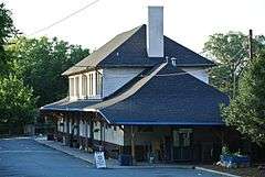
| 88 |
Seaboard Air Line Railroad Passenger Station |
|
000000001980-10-24-0000October 24, 1980
(#80002887) |
1000 N. Tryon St.
35°14′02″N 80°49′59″W / 35.233889°N 80.833056°W / 35.233889; -80.833056 (Seaboard Air Line Railroad Passenger Station) |
Charlotte |
|
| 89 |
Fritz Seifart House |
Upload image |
000000002006-12-20-0000December 20, 2006
(#06001141) |
421 Hempstead Place
35°12′02″N 80°48′56″W / 35.200556°N 80.815556°W / 35.200556; -80.815556 (Fritz Seifart House) |
Charlotte |
|
| 90 |
Siloam School |
Upload image |
000000002007-09-28-0000September 28, 2007
(#07001011) |
West side of Mallard Highlands Dr, Approx. 0.25 miles S from jct. of John Adams Rd.
35°20′10″N 80°44′20″W / 35.336111°N 80.738889°W / 35.336111; -80.738889 (Siloam School) |
Charlotte |
|
| 91 |
Southern Asbestos Company Mills |
|
000000002008-01-30-0000January 30, 2008
(#07001500) |
1000 Seaboard St.
35°14′21″N 80°50′41″W / 35.239167°N 80.844722°W / 35.239167; -80.844722 (Southern Asbestos Company Mills) |
Charlotte |
|
| 92 |
Speas Vinegar Company |
Upload image |
000000002015-08-12-0000August 12, 2015
(#15000530) |
2921 N. Tryon St.
35°15′05″N 80°48′45″W / 35.2513°N 80.8125°W / 35.2513; -80.8125 (Speas Vinegar Company) |
Charlotte |
|
| 93 |
St. Mark's Episcopal Church |
Upload image |
000000001984-03-01-0000March 1, 1984
(#84002410) |
SR 2004; also the southern side of NC 2004 east of its junction with NC 2074
35°20′52″N 80°52′51″W / 35.347778°N 80.880833°W / 35.347778; -80.880833 (St. Mark's Episcopal Church) |
Huntersville |
Second location represents a boundary increase of 000000001991-02-21-0000February 21, 1991
|
| 94 |
Steele Creek Presbyterian Church and Cemetery |
|
000000001991-02-21-0000February 21, 1991
(#91000082) |
7407 Steele Creek Rd.
35°11′03″N 80°57′23″W / 35.184167°N 80.956389°W / 35.184167; -80.956389 (Steele Creek Presbyterian Church and Cemetery) |
Charlotte |
|
| 95 |
Joseph Sykes Brothers Company Building |
|
000000002003-05-01-0000May 1, 2003
(#03000343) |
1445 S. Mint St.
35°13′09″N 80°51′38″W / 35.219167°N 80.860556°W / 35.219167; -80.860556 (Joseph Sykes Brothers Company Building) |
Charlotte |
|
| 96 |
Textile Mill Supply Company Building |
|
000000001999-02-05-0000February 5, 1999
(#99000091) |
1300 S. Mint St.
35°13′17″N 80°51′31″W / 35.221389°N 80.858611°W / 35.221389; -80.858611 (Textile Mill Supply Company Building) |
Charlotte |
|
| 97 |
Union Storage and Warehouse Company Building |
|
000000002001-01-11-0000January 11, 2001
(#00001640) |
1000 W. Morehead St.
35°13′42″N 80°51′31″W / 35.228333°N 80.858611°W / 35.228333; -80.858611 (Union Storage and Warehouse Company Building) |
Charlotte |
|
| 98 |
VanLandingham Estate |
|
000000001983-10-13-0000October 13, 1983
(#83003971) |
2010 The Plaza
35°13′47″N 80°48′30″W / 35.229722°N 80.808333°W / 35.229722; -80.808333 (VanLandingham Estate) |
Charlotte |
|
| 99 |
Victoria |
|
000000001973-04-11-0000April 11, 1973
(#73001359) |
1600 The Plaza
35°13′26″N 80°48′37″W / 35.223889°N 80.810278°W / 35.223889; -80.810278 (Victoria) |
Charlotte |
|
| 100 |
Wesley Heights Historic District |
Upload image |
000000001995-11-29-0000November 29, 1995
(#95001397) |
Bounded by W. Morehead St., Woodruff Pl., Lela Ave., CSX RR tracks, Tuckaseegee Rd., W. Trade St. and S. Summit Ave.
35°13′58″N 80°51′48″W / 35.232778°N 80.863333°W / 35.232778; -80.863333 (Wesley Heights Historic District) |
Charlotte |
|
| 101 |
White Oak Plantation |
Upload image |
000000001978-02-07-0000February 7, 1978
(#78001966) |
E of Charlotte on SR 2826
35°14′54″N 80°41′26″W / 35.248333°N 80.690556°W / 35.248333; -80.690556 (White Oak Plantation) |
Charlotte |
|

.jpg)


.jpg)


_-_Charlotte%2C_NC_-_9-20-2014.jpg)


.jpg)


.jpg)