| [2] |
Name on the Register[3] |
Image |
Date listed[4] |
Location |
City or town |
Description |
|---|
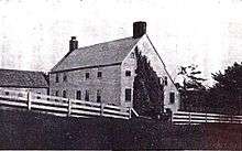
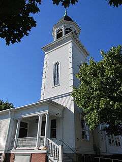
| 1 |
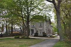
Arkwright Bridge |
|
000000001978-12-12-0000December 12, 1978
(#78000061) |
Crosses the Pawtuxet River at Hill St.
41°43′49″N 71°32′49″W / 41.730278°N 71.546944°W / 41.730278; -71.546944 (Arkwright Bridge) |
Cranston |
Extends into Kent County
|
| 2 |
Edgewood Historic District-Anstis Greene Estate Plats |
Upload image |
000000002015-08-03-0000August 3, 2015
(#15000497) |
Anstis, Broad & Swift Sts., Birchfield & Kensington Rds., Bluff, King, Marion & Rosewood Aves., Narragansett Blvd.
41°46′25″N 71°23′40″W / 41.7737°N 71.3944°W / 41.7737; -71.3944 (Edgewood Historic District-Anstis Greene Estate Plats) |
Cranston |
|
| 3 |
Edgewood Historic District-Arnold Farm Plat |
|
000000002010-09-10-0000September 10, 2010
(#10000733) |
Arnold, Albert, Columbia Aves.; parts of Broad St., Pawtuxet Ave., Narragansett Blvd.
41°46′38″N 71°23′44″W / 41.777222°N 71.395556°W / 41.777222; -71.395556 (Edgewood Historic District-Arnold Farm Plat) |
Cranston |
|
| 4 |
Edgewood Historic District-Taft Estate Plat |
|
000000002003-10-24-0000October 24, 2003
(#03001069) |
Roughly bounded by Windsor Rd., Narragansett Bay, Circuit Dr., and Broad St.; E. side of Narragansett Blvd. between Windsor Rd. & Ocean Ave.
41°46′14″N 71°23′27″W / 41.770556°N 71.390833°W / 41.770556; -71.390833 (Edgewood Historic District-Taft Estate Plat) |
Cranston |
Second set of addresses represents a boundary increase, 2014-12-22
|
| 5 |
Edgewood Historic District-Shaw Plat |
|
000000002013-03-27-0000March 27, 2013
(#13000120) |
Shaw and Marion Aves., parts of Narragansett Boulevard, and Broad St.
41°46′30″N 71°23′41″W / 41.775088°N 71.394829°W / 41.775088; -71.394829 (Edgewood Historic District-Shaw Plat) |
Cranston |
|
| 6 |
Edgewood Yacht Club |
|
000000001989-02-23-0000February 23, 1989
(#89000072) |
3 Shaw Ave.
41°46′34″N 71°23′26″W / 41.776111°N 71.390556°W / 41.776111; -71.390556 (Edgewood Yacht Club) |
Cranston |
|
| 7 |
Thomas Fenner House |
|
000000001990-03-02-0000March 2, 1990
(#90000143) |
43 Stony Acre Dr.
41°47′27″N 71°29′19″W / 41.790833°N 71.488611°W / 41.790833; -71.488611 (Thomas Fenner House) |
Cranston |
|
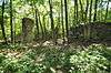
| 8 |
Furnace Hill Brook Historic and Archeological District |
|
000000001980-08-06-0000August 6, 1980
(#80000097) |
off Furnace Hill Road
41°45′20″N 71°29′15″W / 41.755483°N 71.487595°W / 41.755483; -71.487595 (Furnace Hill Brook Historic and Archeological District) |
Cranston |
|
| 9 |
Joy Homestead |
|
000000001971-02-18-0000February 18, 1971
(#71000035) |
156 Scituate Ave.
41°46′57″N 71°28′36″W / 41.7825°N 71.476667°W / 41.7825; -71.476667 (Joy Homestead) |
Cranston |
|
| 10 |
Knightsville Meetinghouse |
|
000000001978-03-08-0000March 8, 1978
(#78000074) |
67 Phenix Ave.
41°46′54″N 71°28′08″W / 41.781667°N 71.468889°W / 41.781667; -71.468889 (Knightsville Meetinghouse) |
Cranston |
|
| 11 |
Lippitt Hill Historic District |
|
000000001989-03-02-0000March 2, 1989
(#89000142) |
Hope Rd., Burlingame Rd., and Lippett Ave.
41°44′23″N 71°32′06″W / 41.739722°N 71.535°W / 41.739722; -71.535 (Lippitt Hill Historic District) |
Cranston |
|
| 12 |
Norwood Avenue Historic District |
|
000000002002-04-26-0000April 26, 2002
(#02000412) |
Roughly along Norwood Ave. between Roger Williams to Broad St.
41°46′51″N 71°24′12″W / 41.780833°N 71.403333°W / 41.780833; -71.403333 (Norwood Avenue Historic District) |
Cranston |
Extends into Providence.
|
| 13 |
Oak Lawn Village Historic District |
|
000000001977-11-25-0000November 25, 1977
(#77000004) |
Wilbur Ave. from Natick Rd. to Oaklawn Ave., includes Searle, Exchange, and Wheelock Sts.
41°44′57″N 71°29′06″W / 41.749167°N 71.485°W / 41.749167; -71.485 (Oak Lawn Village Historic District) |
Cranston |
|
| 14 |
Pawtuxet Village Historic District |
|
000000001973-04-24-0000April 24, 1973
(#73000050) |
Bounded roughly by Bayside, S. Atlantic, and Ocean Aves., the Pawtuxet and Providence rivers, and Post Rd.
41°45′49″N 71°23′27″W / 41.763611°N 71.390833°W / 41.763611; -71.390833 (Pawtuxet Village Historic District) |
Cranston |
|
| 15 |
Potter-Remington House |
Upload image |
000000001978-12-28-0000December 28, 1978
(#78000006) |
571 Natick Rd.
41°44′30″N 71°29′35″W / 41.741667°N 71.493056°W / 41.741667; -71.493056 (Potter-Remington House) |
Cranston |
|
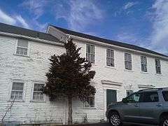
| 16 |
Rhodes-on-the Pawtuxet Ballroom and Gazebo |
Upload image |
000000001978-12-12-0000December 12, 1978
(#78000007) |
Rhodes Pl.
41°46′04″N 71°23′32″W / 41.767778°N 71.392222°W / 41.767778; -71.392222 (Rhodes-on-the Pawtuxet Ballroom and Gazebo) |
Cranston |
|
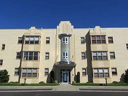
| 17 |
Rosedale Apartments |
|
000000002007-04-10-0000April 10, 2007
(#07000301) |
1180 Narragansett Boulevard
41°46′57″N 71°23′34″W / 41.7825°N 71.392778°W / 41.7825; -71.392778 (Rosedale Apartments) |
Cranston |
|
| 18 |
Sheldon House |
|
000000001989-01-05-0000January 5, 1989
(#88001123) |
458 Scituate Ave.
41°46′47″N 71°29′33″W / 41.779722°N 71.4925°W / 41.779722; -71.4925 (Sheldon House) |
Cranston |
|
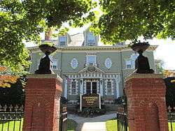
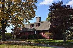
| 19 |
Gov. William Sprague Mansion |
|
000000001971-02-18-0000February 18, 1971
(#71000002) |
1351 Cranston St.
41°47′28″N 71°27′24″W / 41.791111°N 71.456667°W / 41.791111; -71.456667 (Gov. William Sprague Mansion) |
Cranston |
|
| 20 |
Westcote |
|
000000001988-08-03-0000August 3, 1988
(#88001126) |
101 Mountain Laurel Dr.
41°45′19″N 71°28′21″W / 41.755278°N 71.4725°W / 41.755278; -71.4725 (Westcote) |
Cranston |
|
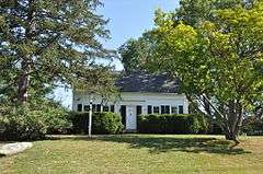
| 21 |
Nathan Westcott House |
|
000000001989-01-05-0000January 5, 1989
(#88001124) |
150 Scituate Ave.
41°46′42″N 71°28′46″W / 41.778333°N 71.479444°W / 41.778333; -71.479444 (Nathan Westcott House) |
Cranston |
|
| 22 |
Arad Wood House |
|
000000001988-08-03-0000August 3, 1988
(#88001125) |
407 Pontiac Ave.
41°46′30″N 71°26′18″W / 41.775°N 71.438333°W / 41.775; -71.438333 (Arad Wood House) |
Cranston |
|


_(extra_close)_(US48).svg.png)