Larkinsburg Township, Clay County, Illinois
| Larkinsburg Township | |
|---|---|
| Township | |
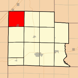 Location in Clay County | |
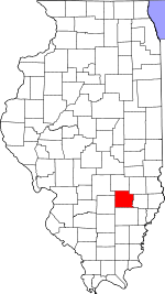 Clay County's location in Illinois | |
| Coordinates: 38°53′N 88°38′W / 38.883°N 88.633°WCoordinates: 38°53′N 88°38′W / 38.883°N 88.633°W | |
| Country | United States |
| State | Illinois |
| County | Clay |
| Established | November 5, 1861 |
| Area | |
| • Total | 37.22 sq mi (96.4 km2) |
| • Land | 37.12 sq mi (96.1 km2) |
| • Water | 0.1 sq mi (0.3 km2) 0.27% |
| Elevation | 499 ft (152 m) |
| Population (2010) | |
| • Total | 644 |
| • Density | 17.3/sq mi (6.7/km2) |
| Time zone | CST (UTC-6) |
| • Summer (DST) | CDT (UTC-5) |
| ZIP codes | 62426, 62838, 62858 |
| GNIS feature ID | 0429234 |
Larkinsburg Township is one of twelve townships in Clay County, Illinois, USA. As of the 2010 census, its population was 644 and it contained 296 housing units.[1]
Geography
According to the 2010 census, the township (T5N R5E) has a total area of 37.22 square miles (96.4 km2), of which 37.12 square miles (96.1 km2) (or 99.73%) is land and 0.1 square miles (0.26 km2) (or 0.27%) is water.[1]
Cities, towns, villages
Cemeteries
The township contains these eight cemeteries: Burge, Fender, Iola, Keen Chapel, Littleton, Price, Rodgers and Woods.
Major highways
Lakes
- Mc Arthur Lake
- Patterson Lake
School districts
- Effingham Community Unit School District 40
- North Clay Community Unit School District 25
- South Central Community Unit School District 401
Political districts
- Illinois' 19th congressional district
- State House District 108
- State Senate District 54
References
- "Larkinsburg Township, Clay County, Illinois". Geographic Names Information System. United States Geological Survey. Retrieved 2010-01-10.
- United States Census Bureau 2007 TIGER/Line Shapefiles
- United States National Atlas
- 1 2 "Population, Housing Units, Area, and Density: 2010 - County -- County Subdivision and Place -- 2010 Census Summary File 1". United States Census. Retrieved 2013-05-28.
External links

Municipalities and communities of Clay County, Illinois, United States | ||
|---|---|---|
| City | ||
| Villages | ||
| Townships | ||
| Unincorporated communities | ||
| Ghost town | ||
| Footnotes | ‡This populated place also has portions in an adjacent county or counties | |
This article is issued from Wikipedia - version of the 12/4/2013. The text is available under the Creative Commons Attribution/Share Alike but additional terms may apply for the media files.