Lakewood (CDP), Wisconsin
| Lakewood, Wisconsin | |
|---|---|
| Census-designated place | |
|
Downtown Lakewood on WIS 32 | |
 Lakewood, Wisconsin | |
| Coordinates: 45°18′03″N 88°31′24″W / 45.30083°N 88.52333°WCoordinates: 45°18′03″N 88°31′24″W / 45.30083°N 88.52333°W | |
| Country | United States |
| State | Wisconsin |
| County | Oconto |
| Area | |
| • Total | 2.781 sq mi (7.20 km2) |
| • Land | 2.781 sq mi (7.20 km2) |
| • Water | 0 sq mi (0 km2) |
| Elevation | 1,280 ft (390 m) |
| Population (2010) | |
| • Total | 323 |
| • Density | 120/sq mi (45/km2) |
| Time zone | Central (CST) (UTC-6) |
| • Summer (DST) | CDT (UTC-5) |
| ZIP code | 54138 |
| Area code(s) | 715 & 534 |
| GNIS feature ID | 1579620[1] |

Lakewood is an unincorporated census-designated place located in the town of Lakewood, Oconto County, Wisconsin, United States. Lakewood is located on Wisconsin Highway 32 22 miles (35 km) north-northwest of Suring. Lakewood has a post office with ZIP code 54138.[2] As of the 2010 census, its population was 323.[3]
History
Lakewood was laid out in 1897.[4] It was named from a lake in the woods near the town site.[4] A post office has been in operation in Lakewood since 1897.[5]
Images
 Nicolet State Trailhead
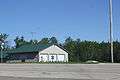 Ambulance service
References
| Wikimedia Commons has media related to Lakewood, Wisconsin. |
- ↑ U.S. Geological Survey Geographic Names Information System: Lakewood (CDP), Wisconsin
- ↑ ZIP Code Lookup
- ↑ "American FactFinder". U.S. Census Bureau. Retrieved 12 April 2011.
- 1 2 Chicago and North Western Railway Company (1908). A History of the Origin of the Place Names Connected with the Chicago & North Western and Chicago, St. Paul, Minneapolis & Omaha Railways. p. 92.
- ↑ "Oconto County". Jim Forte Postal History. Retrieved 21 March 2015.
Municipalities and communities of Oconto County, Wisconsin, United States | ||
|---|---|---|
| Cities |  | |
| Villages | ||
| Towns | ||
| CDPs | ||
| Unincorporated communities | ||
| Indian reservation | ||
| Ghost town |
| |
| Footnotes | ‡This populated place also has portions in an adjacent county or counties | |
This article is issued from Wikipedia - version of the 10/22/2016. The text is available under the Creative Commons Attribution/Share Alike but additional terms may apply for the media files.