Wisconsin Highway 32
| ||||
|---|---|---|---|---|
| 32nd Division Memorial Highway[1] | ||||
 | ||||
| Route information | ||||
| Maintained by WisDOT | ||||
| Length: | 325.69 mi[2] (524.15 km) | |||
| Tourist routes: |
| |||
| Major junctions | ||||
| South end: |
| |||
|
| ||||
| North end: |
| |||
| Location | ||||
| Counties: | Kenosha, Racine, Milwaukee, Ozaukee, Sheboygan, Manitowoc, Calumet, Brown, Shawano, Oconto, Forest, Oneida, Vilas | |||
| Highway system | ||||
| ||||
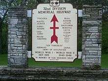
32nd Division Infantry sign in Racine County
State Trunk Highway 32 (often called Highway 32, STH 32 or WIS 32) is a state highway in the U.S. state of Wisconsin that runs north–south in eastern Wisconsin. It runs from the Illinois border (at Illinois Route 137) north to the Michigan border (concurrent with U.S. Highway 45). It is named the 32nd Division Memorial Highway after the U.S. 32nd Infantry Division, and the highway shields have red arrows - the division's logo - on either side of the number 32.[1] The route of WIS 32 has been set by the Wisconsin Legislature in the Wisconsin State Statutes.[3]
Concurrencies
WIS 32 shares its designation, or runs concurrently with, at least 16 different state, U.S. and Interstate Highways over its length. They are:
- WIS 20, for ten blocks in downtown Racine
- WIS 100, at its north end, for a few blocks in Bayside between Port Washington Road and I-43.
- I-43, from Bayside to Grafton and from Port Washington to Cedar Grove
- WIS 57, with I-43 between Mequon and Port Washington, and from the Manitowoc–Sheboygan county line to De Pere
- US 151, for a few blocks in Chilton
- WIS 54, on West Mason Street in Green Bay
- I-41/US 41 freeway from exit 168 to 169 near Green Bay
- WIS 29, from Green Bay to Pulaski
- WIS 22, in Gillett
- WIS 64, through the Nicolet National Forest in Oconto County
- US 8, from Laona to Crandon
- WIS 55, from Crandon to Argonne
- US 45, from Three Lakes to the Michigan state line
- WIS 70, through downtown Eagle River
- WIS 17, near Eagle River
See also
- Sheridan Road, the highway's designation through much of Kenosha and Racine
References
- 1 2 Wisconsin Highways: STH-32 Red Arrow Highway
- ↑ Bessert, Chris. "Wisconsin Highways: Highways 30-39 (Highway 32)". Wisconsin Highways. Retrieved 2007-03-20.
- ↑ "Wisconsin Statute 84.104".
| Wikimedia Commons has media related to Wisconsin Highway 32. |
This article is issued from Wikipedia - version of the 11/21/2016. The text is available under the Creative Commons Attribution/Share Alike but additional terms may apply for the media files.