Kimberly, Minnesota
| Kimberly, Minnesota | |
|---|---|
| Unincorporated community | |
 Kimberly, Minnesota  Kimberly, Minnesota Location of the community of Kimberly | |
| Coordinates: 46°33′39″N 93°27′59″W / 46.56083°N 93.46639°WCoordinates: 46°33′39″N 93°27′59″W / 46.56083°N 93.46639°W | |
| Country | United States |
| State | Minnesota |
| County | Aitkin |
| Township | Kimberly Township |
| Elevation | 1,247 ft (380 m) |
| Time zone | Central (CST) (UTC-6) |
| • Summer (DST) | CDT (UTC-5) |
| ZIP code | 56431 |
| Area code(s) | 218 |
| GNIS feature ID | 646147[1] |
Kimberly is an unincorporated community in Kimberly Township, Aitkin County, Minnesota, United States. The community is located along Aitkin County Road 5 (Nature Avenue) near the junction with County Road 56 (380th Street). Nearby places include Aitkin, Rossburg, Palisade, McGregor, East Lake, and Kimberly Wildlife Management Area. The Rice River flows through the community. State Highways 47 (MN 47) and 210 (MN 210) are both nearby.
History
The community had a post office from 1879 to 1974. Kimberly was named for Moses C. Kimberly, an official of the Northern Pacific Railway.[2]
References
- ↑ "Kimberly, Minnesota". Geographic Names Information System. United States Geological Survey.
- ↑ Upham, Warren (2001). Minnesota Place Names: A Geographical Encyclopedia. Minnesota Historical Society Press. p. 16. ISBN 978-0-87351-396-8.
Municipalities and communities of Aitkin County, Minnesota, United States | ||
|---|---|---|
| Cities | 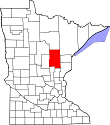 | |
| Townships |
| |
| Unorganized territories | ||
| Unincorporated communities | ||
| Indian reservations | ||
| Footnotes | ‡This populated place also has portions in an adjacent county or counties | |
This article is issued from Wikipedia - version of the 10/30/2016. The text is available under the Creative Commons Attribution/Share Alike but additional terms may apply for the media files.