Ball Bluff, Minnesota
This article is about the community named Ball Bluff in Aitkin County. For the community named Ball Club in adjacent Itasca County, see Ball Club, Minnesota.
| Ball Bluff, Minnesota | |
|---|---|
| Unincorporated community | |
 Ball Bluff, Minnesota  Ball Bluff, Minnesota Location of the community of Ball Bluff | |
| Coordinates: 46°57′17″N 93°16′24″W / 46.95472°N 93.27333°WCoordinates: 46°57′17″N 93°16′24″W / 46.95472°N 93.27333°W | |
| Country | United States |
| State | Minnesota |
| County | Aitkin |
| Township | Ball Bluff Township |
| Elevation | 1,250 ft (380 m) |
| Time zone | Central (CST) (UTC-6) |
| • Summer (DST) | CDT (UTC-5) |
| ZIP code | 55752, 55784, 56469, and 55760 |
| Area code(s) | 218 |
| GNIS feature ID | 654582[1] |
Ball Bluff is an unincorporated community in Ball Bluff Township, Aitkin County, Minnesota, United States. The community is located between Jacobson and McGregor along State Highway 65 (MN 65). The Mississippi River flows nearby.
Nearby places include Jacobson, Swan River, Libby, and Palisade. Ball Bluff is 10 miles south of Swan River, and 26 miles north of McGregor.
The center of Ball Bluff is generally considered at the junction of Highway 65 and 650th Lane / Carmel Church Road. The community is located within the Savanna State Forest in the northeast portion of Aitkin County.
References
Municipalities and communities of Aitkin County, Minnesota, United States | ||
|---|---|---|
| Cities | 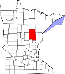 | |
| Townships |
| |
| Unorganized territories | ||
| Unincorporated communities | ||
| Indian reservations | ||
| Footnotes | ‡This populated place also has portions in an adjacent county or counties | |
This article is issued from Wikipedia - version of the 7/28/2016. The text is available under the Creative Commons Attribution/Share Alike but additional terms may apply for the media files.