Itbayat, Batanes
| Itbayat | ||
|---|---|---|
| Municipality | ||
| ||
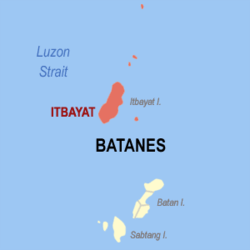 Location within Batanes province | ||
.svg.png) Itbayat Location within the Philippines | ||
| Coordinates: 20°46′N 121°51′E / 20.77°N 121.85°ECoordinates: 20°46′N 121°51′E / 20.77°N 121.85°E | ||
| Country | Philippines | |
| Region | Cagayan Valley (Region II) | |
| Province | Batanes | |
| District | Lone District | |
| Founded | 1935 | |
| Barangays | 6 (see Barangays) | |
| Government [1] | ||
| • Type | Sangguniang Bayan | |
| • Mayor | Reuel C. Ibanes | |
| Area[2] | ||
| • Total | 83.13 km2 (32.10 sq mi) | |
| Highest elevation (Mount Riposet) | 300 m (900 ft) | |
| Population (2015 census)[3] | ||
| • Total | 2,867 | |
| • Density | 34/km2 (89/sq mi) | |
| • Voter (2016)[4] | 1,720 | |
| Time zone | PST (UTC+8) | |
| ZIP code | 3905 | |
| IDD : area code | +63 (0)78 | |
| Income class | 5th class | |
| PSGC | 020902000 | |

Itbayat, officially the Municipality of Itbayat (Filipino: Bayan ng Itbayat), is a municipality in the province of Batanes in the Cagayan Valley (Region II) of the Philippines. The population was 2,867 at the 2015 census.[3] In the 2016 election, it had 1,720 registered voters.[4] Itbayat is the country's northernmost municipality, located about 200 kilometers (120 mi) from the southernmost tip of Taiwan.
In addition to the main island of Itbayat which is the largest in Batanes, the municipality includes the rest of the province's northern islands, all small and mostly uninhabited. These islands are, from south to north: Diogo, Siayan, Maysanga, Mabudis, North, and Mavulis (also known as Y'ami), the northernmost island of the Philippine archipelago.
History
While the church and civil government were already established in Batan Island in 1783, it was only in 1855 that civil authority was officially established and the mission canonically founded in Itbayat. A mere settlement during the Spanish colonial period, it became a municipal district when the Americans organized the province in 1909. However, in 1935, it became a municipality.
Typhoon Ferdie made landfall on September 14, 2016, with the center of the eye passing directly over the island.[5]
Geography
Itbayat is located at 20°46′N 121°51′E / 20.77°N 121.85°E.
According to the Philippine Statistics Authority, the municipality has a land area of 83.13 square kilometres (32.10 sq mi)[2] constituting 37.96% of the 219.01-square-kilometre- (84.56 sq mi) total area of Batanes.
Barangays
Itbayat is politically subdivided into 5 barangays.[6]
| PSGC | Barangay | Population | ±% p.a. | ||
|---|---|---|---|---|---|
| 2015[3] | 2010[7] | ||||
| 020902006 | Raele | 16.2% | 465 | 442 | +0.97% |
| 020902007 | San Rafael (Idiang) | 26.0% | 745 | 789 | −1.09% |
| 020902008 | Santa Lucia (Kauhauhasan) | 14.7% | 422 | 478 | −2.34% |
| 020902009 | Santa Maria (Marapuy) | 16.1% | 463 | 438 | +1.06% |
| 020902010 | Santa Rosa (Kaynatuan) | 26.9% | 772 | 841 | −1.62% |
| Total | 2,867 | 2,988 | −0.78% | ||
Demographics
| Population census of Itbayat | |||||||||||||||||||||||||
|---|---|---|---|---|---|---|---|---|---|---|---|---|---|---|---|---|---|---|---|---|---|---|---|---|---|
|
| ||||||||||||||||||||||||
| Source: PSA[3][7][8] | |||||||||||||||||||||||||
In the 2015 census, Itbayat had a population of 2,867.[3] The population density was 34 inhabitants per square kilometre (88/sq mi).
In the 2016 election, it had 1,720 registered voters.[4]
Attractions
- Siayan Island: the nearest island to the north of Itbayat. It has beaches accessible by a one-hour ride by motorboat from Itbayat (depending on sea condition).
- Di'nem Island: Also known as Diogo Island, this volcanic island east of Itbayat features boulder beaches with towering cliffs good for mountain climbing.
- Rapang Cliff: A natural park with a ringing mushroom-like rock. It is believed to have been used by the ancient settlers to call a meeting.
- Mount Riposet: One of the two volcanoes that have been the foundation of Itbayat Island. This extinct volcano in the south-eastern part of Itbayat has an elevation of 900 feet (270 m) that offers a panoramic view of the island.[9]
- Mount Karaboboan (Mount Santa Rosa): The other extinct volcano of Itbayat Island is in the island's northern half.[9] Near the 800-foot (240 m) mountain is a settlement of the early settlers of Itbayat near Barangay Santa Rosa.
- Torongan Cave: The most ancient dwelling place has a burial ground on top. It is believed to be the first landing place of the Austronesians from Taiwan around 2000 BC.
- Nahini Votox: With its own Ijang and boat-shaped burial grounds, it is also an ancient settlement where many broken clay pots have been found. Its Ijang has a spectacular view of Dinem and Itbayat Island's eastern coast.
- Underground Stream in Kumayasakas: The stream flows down the sea, north-west of Itbayat.
- Itbayat Caves: These caves feature stalagmites and stalactites, and have been given the names Northern Sarokan, Eastern Sarokan, Do'tboran Cave, and Pevangan Cave.
- Agosan Rock: rock formation north of Itbayat which is a breeding site for endangered birds.
- Vernacular houses: A typical vernacular house is composed of three structures:
- (the kitchen where they use kugon to cook
- the actual house where people stay
- the bathroom).
- Port Mauyen: An alternative port south of Itbayat with a 14-turn zigzag road. It is 14 kilometres (8.7 mi) south of the town.
- Groto: 155 steps up
Transportation
Reaching Itbayat by a direct route from Manila is by plane via Itbayat Airport. There is a commercial carrier that provides flights to Itbayat from Basco, the capital of Batanes:
- SkyPasada
- NorthSky Air
Sea transport companies that service Itbayat are:
- M/B Ocean Spirit
- M/B Itranza
- M/B Veronica
References
- ↑ "Municipality". Quezon City, Philippines: Department of the Interior and Local Government. Retrieved 31 May 2013.
- 1 2 "Province: Batanes". PSGC Interactive. Makati City, Philippines: Philippine Statistics Authority. Retrieved 23 November 2016.
- 1 2 3 4 5 "Region II (CAGAYAN VALLEY)". Census of Population (2015): Total Population by Province, City, Municipality and Barangay (Report). PSA. Retrieved 20 June 2016.
- 1 2 3 "2016 National and Local Elections Statistics". Commission on Elections. 2016.
- ↑ Clark, Steven (14 September 2016). "Eye of typhoon Meranti passes over Philippines' Itbayat". Channel NewsAsia. Retrieved 14 September 2016.
- ↑ "Municipal: Itbayat, Batanes". PSA. Philippines: National Statistical Coordination Board. Retrieved 8 January 2016.
- 1 2 "Region II (CAGAYAN VALLEY)". Census of Population and Housing (2010): Total Population by Province, City, Municipality and Barangay (Report). NSO. Retrieved 29 June 2016.
- ↑ "Region II (CAGAYAN VALLEY)". Census of Population (1995, 2000 and 2007): Total Population by Province, City and Municipality (Report). NSO. Archived from the original on 24 June 2011.
- 1 2 United States Coast and Geodetic Survey (1919). "United States Coast Pilot - Philippine Islands", pg. 38. Government Printing Office, Washington.
 |
Bashi Channel (Luzon Strait) |
Bashi Channel (Luzon Strait) |
| |
| South China Sea | |
Philippine Sea | ||
| ||||
| | ||||
| Sabtang | Basco |