Mahatao, Batanes
| Mahatao | ||
|---|---|---|
| Municipality | ||
|
| ||
| ||
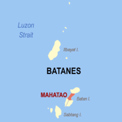 Location within Batanes province | ||
.svg.png) Mahatao Location within the Philippines | ||
| Coordinates: 20°25′N 121°57′E / 20.42°N 121.95°ECoordinates: 20°25′N 121°57′E / 20.42°N 121.95°E | ||
| Country | Philippines | |
| Region | Cagayan Valley (Region II) | |
| Province | Batanes | |
| District | Lone District | |
| Barangays | 4 (see Barangays) | |
| Government [1] | ||
| • Type | Sangguniang Bayan | |
| • Mayor | William A. Agsunod | |
| Area[2] | ||
| • Total | 12.9 km2 (5.0 sq mi) | |
| Population (2015 census)[3] | ||
| • Total | 1,555 | |
| • Density | 120/km2 (310/sq mi) | |
| • Voter (2016)[4] | 1,134 | |
| Time zone | PST (UTC+8) | |
| ZIP code | 3901 | |
| IDD : area code | +63 (0)78 | |
| Income class | 6th class | |
| PSGC | 020904000 | |

Mahatao, officially the Municipality of Mahatao (Filipino: Bayan ng Mahatao), is a municipality in the province of Batanes in the Cagayan Valley (Region II) of the Philippines. The population was 1,555 at the 2015 census.[3] In the 2016 election, it had 1,134 registered voters.[4]
Geography
Mahatao is located at 20°25′N 121°57′E / 20.42°N 121.95°E.
According to the Philippine Statistics Authority, the municipality has a land area of 12.9 square kilometres (5.0 sq mi)[2] constituting 5.89% of the 219.01-square-kilometre- (84.56 sq mi) total area of Batanes.
Barangays
Mahatao is politically subdivided into 4 barangays.[5] Hanib was corrected into Hañib by the Philippine Statistics Authority.[6]
| PSGC | Barangay | Population | ±% p.a. | ||
|---|---|---|---|---|---|
| 2015[3] | 2010[7] | ||||
| 020904001 | Hañib | 23.5% | 365 | 372 | −0.36% |
| 020904002 | Kaumbakan | 27.3% | 425 | 483 | −2.41% |
| 020904003 | Panatayan | 28.9% | 449 | 416 | +1.46% |
| 020904004 | Uvoy (Poblacion) | 20.3% | 316 | 312 | +0.24% |
| Total | 1,555 | 1,583 | −0.34% | ||
Demographics
| Population census of Mahatao | |||||||||||||||||||||||||
|---|---|---|---|---|---|---|---|---|---|---|---|---|---|---|---|---|---|---|---|---|---|---|---|---|---|
|
| ||||||||||||||||||||||||
| Source: PSA[3][7][8] | |||||||||||||||||||||||||
In the 2015 census, Mahatao had a population of 1,555.[3] The population density was 120 inhabitants per square kilometre (310/sq mi).
In the 2016 election, it had 1,134 registered voters.[4]
References
- ↑ "Municipality". Quezon City, Philippines: Department of the Interior and Local Government. Retrieved 31 May 2013.
- 1 2 "Province: Batanes". PSGC Interactive. Makati City, Philippines: Philippine Statistics Authority. Retrieved 23 November 2016.
- 1 2 3 4 5 "Region II (CAGAYAN VALLEY)". Census of Population (2015): Total Population by Province, City, Municipality and Barangay (Report). PSA. Retrieved 20 June 2016.
- 1 2 3 "2016 National and Local Elections Statistics". Commission on Elections. 2016.
- ↑ "Municipal: Mahatao, Batanes". PSA. Philippines: National Statistical Coordination Board. Retrieved 8 January 2016.
- ↑ "I. Renaming and Corrections of Names". Philippine Statistics Authority. 21 September 2016. Retrieved 26 October 2016.
- 1 2 "Region II (CAGAYAN VALLEY)". Census of Population and Housing (2010): Total Population by Province, City, Municipality and Barangay (Report). NSO. Retrieved 29 June 2016.
- ↑ "Region II (CAGAYAN VALLEY)". Census of Population (1995, 2000 and 2007): Total Population by Province, City and Municipality (Report). NSO. Archived from the original on 24 June 2011.
External links
| Wikimedia Commons has media related to Mahatao, Batanes. |
 |
Basco | | ||
| South China Sea | |
Philippine Sea | ||
| ||||
| | ||||
| Ivana / Uyugan |