Sabtang, Batanes
| Sabtang | ||
|---|---|---|
| Municipality | ||
|
Island seascape | ||
| ||
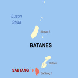 Location within Batanes province | ||
.svg.png) Sabtang Location within the Philippines | ||
| Coordinates: 20°20′N 121°52′E / 20.33°N 121.87°ECoordinates: 20°20′N 121°52′E / 20.33°N 121.87°E | ||
| Country | Philippines | |
| Province | Batanes | |
| District | Lone District | |
| Barangays | 6 (see Barangays) | |
| Government [1] | ||
| • Type | Sangguniang Bayan | |
| • Mayor | Maxilindo E. A. Babalo | |
| Area[2] | ||
| • Total | 40.7 km2 (15.7 sq mi) | |
| Population (2015 census)[3] | ||
| • Total | 1,621 | |
| • Density | 40/km2 (100/sq mi) | |
| • Voter (2016)[4] | 1,235 | |
| Demonym(s) | Sabteño | |
| Time zone | PST (UTC+8) | |
| ZIP code | 3904 | |
| IDD : area code | +63 (0)78 | |
| Income class | 6th class | |
| PSGC | 020905000 | |
| Website |
www | |

Sabtang, officially the Municipality of Sabtang (Filipino: Bayan ng Sabtang), is a municipality in the province of Batanes in the Cagayan Valley (Region II) of the Philippines. The population was 1,621 at the 2015 census.[3] In the 2016 election, it had 1,235 registered voters.[4]
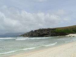
The southernmost island municipality of the Batanes island group, Sabtang comprises primarily Sabtang Island, as well as two nearby smaller and uninhabited islands: Ivuhos and Dequey. The municipality is known for its lighthouse and the old stone houses of the Ivatan villages of Chavayan and Savidug. Like Batan Island to the north, Sabtang also has a few Mission-style churches and white sand beaches.
History
The Spanish missionary Fr. Artiquez first visited the Island of Sabtang in 1786[5] after receiving an affirmative response from the island to learn about the Christian faith. The success of the first visit led to two more evangelical trips resulting in the baptism of 181 children and the study of the catechism among the adult natives. The evangelization of Sabtang was cut short due to the failing health of the Spanish missionaries. For this, the inhabitants of Sabtang remained faithful to old traditions especially in the administration of justice by vendetta and murder.[5]
In 1791, the then most powerful chief in Sabtang named Aman Dangat showed defiance of the government of Governor Joaquin del Castillo by killing the Spanish soldiers who went to Sabtang to procure supplies. Lieutenant Tomas Nuñez led the troops to capture the rebels. Aman Dangat was put to trial and admitted to the crime. He later on asked to be baptized. The inhabitants of Sabtang were then forced to resettle in San Vicente and San Felix in Ivana to be better supervised by the government.[5]
Some forty years after the resettlement, the Sabteños were allowed to visit their native island and gradually these visits allowed them to build homes in their erstwhile land. The government allowed this to happen on the condition that houses should be constructed in lowlands.[5] To sustain the spiritual care for the Sabteños, a new mission was opened in Sabtang in 1845 under the patronage of Saint Vincent Ferrer with Fr. Antonio Vicente as its first vicar. Fr. Antonio Vicente is credited to have built the Sabtang Church, together with a convent, a school, and a courthouse.[5]
Geography
Sabtang is located at 20°20′N 121°52′E / 20.33°N 121.87°E.
According to the Philippine Statistics Authority, the municipality has a land area of 40.7 square kilometres (15.7 sq mi)[2] constituting 18.58% of the 219.01-square-kilometre- (84.56 sq mi) total area of Batanes.
Barangays
Sabtang is politically subdivided into 6 barangays.[6]
| PSGC | Barangay | Population | ±% p.a. | ||
|---|---|---|---|---|---|
| 2015[3] | 2010[7] | ||||
| 020905001 | Chavayan | 9.7% | 157 | 169 | −1.39% |
| 020905002 | Malakdang (Poblacion) | 14.4% | 234 | 245 | −0.87% |
| 020905003 | Nakanmuan | 8.8% | 142 | 134 | +1.11% |
| 020905004 | Savidug | 12.4% | 201 | 190 | +1.08% |
| 020905005 | Sinakan (Poblacion) | 31.4% | 509 | 552 | −1.53% |
| 020905006 | Sumnanga | 23.3% | 378 | 347 | +1.64% |
| Total | 1,621 | 1,637 | −0.19% | ||
Demographics
| Population census of Sabtang | |||||||||||||||||||||||||
|---|---|---|---|---|---|---|---|---|---|---|---|---|---|---|---|---|---|---|---|---|---|---|---|---|---|
|
| ||||||||||||||||||||||||
| Source: PSA[3][7][8] | |||||||||||||||||||||||||
In the 2015 census, Sabtang had a population of 1,621.[3] The population density was 40 inhabitants per square kilometre (100/sq mi).
In the 2016 election, it had 1,235 registered voters.[4]
Gallery
-
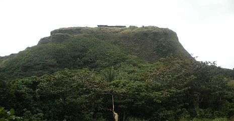
The Idjang castle in Savidug
-

Beach in Sabtang

References
- ↑ "Municipality". Quezon City, Philippines: Department of the Interior and Local Government. Retrieved 31 May 2013.
- 1 2 "Province: Batanes". PSGC Interactive. Makati City, Philippines: Philippine Statistics Authority. Retrieved 23 November 2016.
- 1 2 3 4 5 "Region II (CAGAYAN VALLEY)". Census of Population (2015): Total Population by Province, City, Municipality and Barangay (Report). PSA. Retrieved 20 June 2016.
- 1 2 3 "2016 National and Local Elections Statistics". Commission on Elections. 2016.
- 1 2 3 4 5 González Alonzo, Fr. Julio, O.P. (1966). "The Batanes Islands", in Acta Manilana, Manila: University of Santo Tomas Research Center
- ↑ "Municipal: Sabtang, Batanes". PSA. Philippines: National Statistical Coordination Board. Retrieved 8 January 2016.
- 1 2 "Region II (CAGAYAN VALLEY)". Census of Population and Housing (2010): Total Population by Province, City, Municipality and Barangay (Report). NSO. Retrieved 29 June 2016.
- ↑ "Region II (CAGAYAN VALLEY)". Census of Population (1995, 2000 and 2007): Total Population by Province, City and Municipality (Report). NSO. Archived from the original on 24 June 2011.
External links
| Wikimedia Commons has media related to Sabtang, Batanes. |
 |
Itbayat Luzon Strait |
Ivana | | |
| South China Sea | |
Philippine Sea | ||
| ||||
| | ||||
| Balintang Channel (Luzon Strait) Calayan, Cagayan |