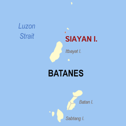
Siayan Island
| Native name: <span class="nickname" ">Ditarem | |
|---|---|
 | |
.svg.png) Siayan Location within the northern extremity of the Philippines | |
| Geography | |
| Location | Luzon Strait |
| Coordinates | 20°54′12″N 121°54′10″E / 20.90333°N 121.90278°ECoordinates: 20°54′12″N 121°54′10″E / 20.90333°N 121.90278°E |
| Archipelago | Batanes Group of Islands |
| Administration | |
| Region | Cagayan Valley |
| Province | Batanes |
Siayan is one of the Batanes Islands. Also known as Ditarem Island in the native language,[1] the island is about 1/2 mile to 3/4 miles in diameter and lies about 5 miles (8 km) north-northeastward of Itbayat Island. The closest island is Mabudis Island which is about 1 1⁄2 miles north-northeastward of Siayan. There are several detached rocks off Siayan's northeast side, rendering the channel between it and Mabudis unsafe for larger vessels.[2]
Siayan has an elevation of 538 ft (164 m) and is listed as an inactive volcano[3] by the Philippine Institute of Volcanology and Seismology.
See also
References
- ↑ University of Georgia, Yami culture of Taiwan, Retrieved on 2010-08-24
- ↑ U.S. Coast and Geodetic Survey, Department of Commerce. United States Coast Pilot, Philippine Islands Part I, p. 39. Washington Government Printing Office, 1919.
- ↑ PHILVOCS, List of Inactive Volcanoes in the Philippines. Retrieved on 2010-08-24.
This article is issued from Wikipedia - version of the 11/24/2016. The text is available under the Creative Commons Attribution/Share Alike but additional terms may apply for the media files.