Indiana State Road 10
| ||||
|---|---|---|---|---|
 | ||||
| Route information | ||||
| Maintained by INDOT | ||||
| Length: | 85.3 mi[1] (137.3 km) | |||
| Existed: | October 1, 1926[2] – present | |||
| Major junctions | ||||
| West end: |
| |||
|
| ||||
| East end: |
| |||
| Location | ||||
| Counties: | Newton, Jasper, Starke, Marshall | |||
| Highway system | ||||
| ||||

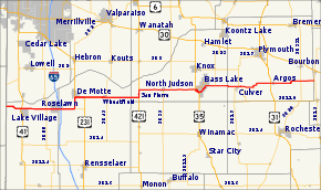
State Road 10 (SR 10) is an east–west road in northwest Indiana. Its western terminus is at the Illinois state line west of Lake Village. Its eastern terminus is at State Road 19 (SR 19) south of Etna Green.
Route description
From its western terminus at the Illinois state line, SR 10 heads east; after 3.99 miles (6.42 km) it has an intersection with U.S. Route 41 (US 41). SR 10 then has an interchange with Interstate 65 (I-65) at exit number 230 on I-65. After I-65, SR 10 has an intersection with State Road 110 and SR 10 heads due north. Then SR 10 turns east onto U.S. Route 231 and both routes go due east until US 231 turns due south on its way to Lafayette. SR 10 continues due east toward U.S. Route 421 (US 421), passing though Wheatfield where it meets State Road 49 (SR 49). At US 421, SR 10 turns north onto US 421. After a short concurrency with US 421, SR 10 turns east. Then SR 10 meets U.S. Route 35 (US 35); SR 10 and US 35 have a short concurrency heading southeast. Then SR 10 leaves US 35 to the north, northeast, and then east. Near Argos SR 10 has an intersection with U.S. Route 31 (US 31). After US 31, heads east to its eastern terminus at SR 19.[3]
History
From 1918 to 1926, SR 10 followed a portion of the route of the modern U.S. Route 41 (US 41). This route was part of the old number system that was in place in Indiana. The current SR 10 route was designated SR 50 from Wheatfield to Argos; the rest was made up of unnumbered roads. Then in 1926, SR 10 changed to its current route.[2] In the early 1960s, SR 10 was rerouted onto US 35 near Bass Lake and at that time State Road 210 (SR 210) was decommissioned.
Major intersections
| County | Location | mi[1] | km | Destinations | Notes |
|---|---|---|---|---|---|
| Newton | Lake Village | 0.00 | 0.00 | Illinois state line | |
| 3.99 | 6.42 | Formerly SR 10 | |||
| Roselawn | 10.25 | 16.50 | |||
| Jasper | 13.78 | 22.18 | Interchange | ||
| DeMotte | 17.26 | 27.78 | Western terminus of SR 110 | ||
| 20.37 | 32.78 | Western end of US 231 concurrency | |||
| 22.75 | 36.61 | Eastern end of US 231 concurrency | |||
| Wheatfield | 28.19 | 45.37 | |||
| Starke | San Pierre | 36.18 | 58.23 | Southern end of US 421 concurrency | |
| 38.16 | 61.41 | Northern end of US 421 concurrency | |||
| North Judson | 44.21 | 71.15 | Western end of SR 39 concurrency | ||
| 46.28 | 74.48 | Eastern end of SR 39 concurrency | |||
| Bass Lake | 52.22 | 84.04 | Western end of US 35 concurrency | ||
| 53.61 | 86.28 | Eastern end of US 35 concurrency | |||
| Beach Drive | Former western terminus of SR 210 | ||||
| Lakeshore Drive | Former eastern terminus of SR 210 | ||||
| 58.96 | 94.89 | Southern terminus of SR 23 | |||
| Marshall | Culver | 63.86 | 102.77 | Western end of SR 17 concurrency | |
| 64.84 | 104.35 | Eastern end of SR 17 concurrency | |||
| 65.79 | 105.88 | Northern terminus of SR 117 | |||
| Argos | 73.89 | 118.91 | |||
| Michigan Street | Former routing of US 31 | ||||
| Tippecanoe Township | 81.90 | 131.81 | |||
| 85.30 | 137.28 | ||||
1.000 mi = 1.609 km; 1.000 km = 0.621 mi
| |||||
References
- 1 2 "INDOT Roadway Referencing System" (PDF). staff.
- 1 2 "Road Numbers to Be Changed". The Hancock-Democrat. The Indianapolis News. September 30, 1926. Retrieved June 9, 2016 – via Newspapers.com.

- ↑ Google (2010-12-31). "overview map of SR 10" (Map). Google Maps. Google. Retrieved 2010-12-31.