Ickham and Well
| Ickham and Well | |
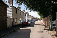 The Street, Ickham |
|
 Ickham and Well |
|
| Area | 9.3 km2 (3.6 sq mi) |
|---|---|
| Population | 437 (Civil Parish 2011)[1] |
| – density | 47/km2 (120/sq mi) |
| OS grid reference | TR221581 |
| Civil parish | Ickham and Well |
| District | City of Canterbury |
| Shire county | Kent |
| Region | South East |
| Country | England |
| Sovereign state | United Kingdom |
| Post town | CANTERBURY |
| Postcode district | CT3 |
| Dialling code | 01227 |
| Police | Kent |
| Fire | Kent |
| Ambulance | South East Coast |
| EU Parliament | South East England |
| UK Parliament | Canterbury |
Coordinates: 51°16′N 1°11′E / 51.27°N 1.19°E
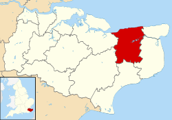
Ickham and Well is a mostly rural civil parish east of Canterbury in Kent, South East England.
The parish covers the villages of Ickham and Bramling just off the A257 Sandwich Road. It has several listed buildings in architecture of old, well-preserved houses, with the 13th-century Parish Church of St John the Evangelist in the midst. A recent archaeological excavation at Ickham has revealed evidence of Roman metalwork and copper broaches.[2]
Geography
Ickham centres on a single road.
The Rivers Little Stour and Wingham flow through the parish before joining with the Great Stour to become the River Stour.

Ickham Village hall
References
External links
 Media related to Ickham and Well at Wikimedia Commons
Kent Portal | |
| Unitary authorities | |
| Boroughs or districts | |
| Major settlements |
|
| Rivers | See: Rivers of Kent |
| Topics | |
This article is issued from Wikipedia - version of the 10/21/2016. The text is available under the Creative Commons Attribution/Share Alike but additional terms may apply for the media files.