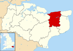
Chislet
| Chislet | |
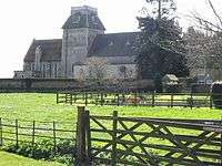 St Mary the Virgin, a Grade I listed church[1] in Chislet village |
|
 Chislet |
|
| Area | 18.25 km2 (7.05 sq mi) |
|---|---|
| Population | 872 (Civil Parish 2011)[2] |
| – density | 48/km2 (120/sq mi) |
| OS grid reference | TR2264 |
| Civil parish | Chislet |
| District | City of Canterbury |
| Shire county | Kent |
| Region | South East |
| Country | England |
| Sovereign state | United Kingdom |
| Post town | CANTERBURY |
| Postcode district | CT3 |
| Police | Kent |
| Fire | Kent |
| Ambulance | South East Coast |
| EU Parliament | South East England |
| UK Parliament | North Thanet |
Coordinates: 51°20′02″N 1°11′29″E / 51.334°N 1.1913°E
Chislet is an English village and rural parish in northeast Kent between Canterbury and the Isle of Thanet. The parish is the second largest in the district. A former spelling, 'Chistlet', is seen in 1418. The population of the civil parish includes the hamlet of Marshside. Most of the land use is fertile agricultural and a significant minority of the land is marsh where low-lying.[3][4]
Geography
The Chislet marshes mark the western end of the Wantsum Channel, an arm of the North Sea that separated the Isle of Thanet from the mainland. Saltmaking was an important activity in the marshes in ancient times. Chislet Windmill stood north of the Thanet Way on the road to Reculver until it burnt down in 2005; a replica of the exterior minus sales was built on the same site in 2011 during a housing redevelopment.
Economic history
The Anglo-Westphalian Coal Syndicates Ltd was set up in 1911 to lease land near Chislet and after various setbacks they finally moved approximately 2 miles to the south to the south side of the A28 to take advantage of the road on one side and the rail on the other sinking started in 1914 with control taken over from the German company a new company set up called The Chislet Colliery Limited they finally reached the coal in 1918 at 1350 ft (411 metres) Chislet Colliery Housing Society was formed in 1924 to build a small colliery village of 300 houses North of the colliery on the main road to Thanet.formally called Chislet Colliery Village the name was changed to Hersden in 1929 to avoid confusion with Chislet village some 2 miles away[5] Until its closure in July 1969, Chislet was the most northerly colliery in Kent.
Localities
Chislet parish includes the villages or localities:
- Boyden Gate
- Chislet
- Chislet Forstal
- Highstead
- Marshside
- Upstreet
References
- ↑ British Listed Buildings retrieved 19 July 2013
- ↑ Key Statistics; Quick Statistics: Population Density United Kingdom Census 2011 Office for National Statistics Retrieved 21 November 2013
- ↑ British History website: http://www.british-history.ac.uk/report.aspx?compid=63543 ; village of Chistlet
- ↑ Plea Rolls of the Court of Common Pleas; National Archives; CP 40 / 629; http://aalt.law.uh.edu/H5/CP40no629/aCP40no629fronts/IMG_0084.htm; the defendant in the third entry comes from this place: Simon Littelwode, of Chistlet, husbandman
- ↑ Chislet colliery
External links
| Wikimedia Commons has media related to Chislet. |