Horbling
| Horbling | |
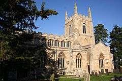 St Andrew's Church, Horbling |
|
 Horbling |
|
| Population | 397 (2001)[1] |
|---|---|
| OS grid reference | TF118352 |
| – London | 95 mi (153 km) S |
| District | South Kesteven |
| Shire county | Lincolnshire |
| Region | East Midlands |
| Country | England |
| Sovereign state | United Kingdom |
| Post town | Sleaford |
| Postcode district | NG34 |
| Police | Lincolnshire |
| Fire | Lincolnshire |
| Ambulance | East Midlands |
| EU Parliament | East Midlands |
| UK Parliament | Grantham and Stamford |
|
|
Coordinates: 52°54′12″N 0°20′17″W / 52.903428°N 0.338050°W
Horbling is a village and civil parish in the South Kesteven district of Lincolnshire, England. It lies on the B1177, 7 miles (11 km) south-east from Sleaford, 14.5 miles (23 km) north-east from Grantham, and 0.5 miles (0.8 km) north from Billingborough.
Village population recorded in the 2001 census was 397 in 162 households.[1]
History
Horbling is the site of a probable Romano-British settlement, centred around the present Fen Drove and Fen Farm, on Horbling Fen to the east, where has been found earthwork evidence of rectilinear enclosures, and watercourses.[2] Large quantities of Roman Samian ware and roof tiles have also been discovered.[3] Cox noted that on the right hand side of road from Billingborough to Horbling is a tumulus, probably of pre-historic origin.[4]
In the Domesday account the village is written as "Horbelinge". It consisted of 9 villagers, 8 freemen and one smallholder, land for 4 plough teams, a 20 acres (0.081 km2) meadow and a church. Before the conquest Thorkill the Dane was lord of the manor, in 1086 lordship was transferred to Walter D'Aincourt.[5][6]
A hamlet of Horbling, Bridge End, (previously also Holland Brigg) 1.5 miles (2.4 km) to the east, is the site of the small Gilbertine priory of St Saviour, founded in 1199 by Godwin the Rich of Lincoln.[7][8] The canons at Bridgend Priory were charged with the upkeep of Holland Bridge causeway (de ponte Aslaci), a Roman road running from the Midlands to The Wash.[4] Cox also noted: "It had a slender endowment and was probably never occupied by more than 2 or 3 canons". A parcel of land and messuage at the head of the causeway near the priory was given by Robert Jokem of Horbling to St Saviour's, to support the work of the canons.[9] The causeway stretched between Horbling and Donington and was, until the 18th century, the only sound road between Kesteven and Holland.[10] In 1816, Marrat recorded that Bridge End "consists of a few farm houses, and a tolerably good Inn." The priory had been taken down 45 years previously (c.1770), and its materials used for a large farmhouse virtually on the same site. Two miles to the east of the Bridge End was built a chapel where prayers were said for the safety of travellers.[9]
The Medieval Stow Fair was held 1.5 miles (2.4 km) to the west of the village at the junction of Mareham Lane and Stow Lane from 1233, and lasted until 1954.[11] According to a district council notice board at the site, the fair, traditionally held on 23 June, was probably dedicated to St Ætheldreda.
In 1885 Kelly's Directory noted that the village was on the Bourne and Sleaford branch of the Great Northern Railway, and that the principal dwellings were supplied by the Billingborough and Horbling Gas Company. Agricultural production in a parish of 2,620 acres (10.6 km2) was chiefly wheat, barley, beans and oats. Its population in 1881 was 501. The Lord of the Manor was a George Shaw, and chief landowners were Edward Nathaniel Conant, George Shaw and Captain Henry Smith JP. A school for boys and girls was originally established by Edward Brown of Horbling (d.1692) with endowments provided by income from his lands at Wigtoft. A new National School schoolhouse was erected in 1865 for the free education of 11 boys and 9 girls.[12]

Up to 1905 existed Horbling Windmill.[13]
Between 1939 and 1948 an area on the south side of Sandygate Lane was used to accommodate a prisoner of war camp. As Camp 80, it held German prisoners who were used as local labourers. Housing now occupies the camp site.[14]
Billingboro and Horbling railway station closed in 1964, after ceasing to be a passenger carrier over 30 years previously. It was built in 1872 through an act of Parliament of 1865. After closure the line to the north of the station was used to store the Royal Train.[15] The remains of the line just to the west of the village has become a nature reserve for small wildlife under the Lincolnshire Wildlife Trust.[16]
Landmarks
Horbling parish church is Grade I listed and dedicated to St Andrew.[17]
The church is of cruciform construction in Norman, Early English and later styles. It comprises a chancel, clerestoried nave, aisles, transepts and embattled tower with pinnacles and 5 bells. The chancel contains a piscina and sedilia, and Norman arcading in the west front. The tower, owing to bad foundations was successively rebuilt or repaired in transitional, Early English and early Decorated periods. The north aisle and transept are late Decorative, as is the font. The south aisle and transept, and clerestory, are Perpendicular. Stained glass in the west window was added in 1854 as testimonial to Benjamin Smith (1776-1857),[12] local solicitor and promoter of charities,[18] who paid for the 1852 restoration of church. The south transept holds memorials to the Brown family. In the north transept is a mid-14th-century monument with effigies of knight and lady, with the arms of De La Maine.[12] Above these effigies is a lunette containing a relief of Christ's resurrection, flanked by two figures.[4][19] Pevsner also notes two 1706 patens by John Cory, a 1713 flagon by Humphrey Payne, an 1840 alms dish attributable to John Crouch, and a brass plate designed by Pugin, who also perhaps designed the brass to Benjamin Wilkinson (d.1848).[19] Marrat, in 1816, recorded: "The inside [of] the church is not in good repair, here are some very indiferent stalls, and scarcely any pews".[9]

A spring well rises 150 yards (137.2 m) north from the church on Spring Lane: "a deep open cistern feeds water to three adjacent troughs".[19] The well, paid for by the Constables of Horbling, dates from 1711. It has an added 1981 inscription commemorating the marriage of the Prince of Wales to Lady Diana Spencer, and is Grade II* listed.[20]
Horbling Hall is an 1860 Grade II listed house on Horbling High Street.[21] Pevsner, describing the village as mostly Georgian, mentions that the Hall was tudorized in 1880.[19]
The Plough Inn is the Horbling village public house, a Grade II listed early 19th-century building on Springwell Lane,[22] with its listed stables.[23]
The Old Vicarage is a Grade II c.1870 red-brick house on Church Lane,[24] with its listed carriagehouse and tack room.[25]
Further notable buildings include farmhouses, cottages, houses and minor structures.[26]
References
- 1 2 "Neighbourhood statistics". 2001 census. Office for national statistics. Retrieved 20 April 2013.
- ↑ Historic England. "Monument No. 350870". PastScape. Retrieved 14 April 2012.
- ↑ Historic England. "Monument No. 350862". PastScape. Retrieved 14 April 2012.
- 1 2 3 Cox, J. Charles (1916) Lincolnshire pp. 168, 169, 170; Methuen & Co. Ltd.
- ↑ Horbling in the Domesday Book. Retrieved 14 April 2012.
- ↑ "Documents Online: Horbling, Lincolnshire", Folio: 340r, Great Domesday Book; The National Archives. Retrieved 14 April 2012
- ↑ "The Priory of St Saviour, Bridgend in Horbling"; British History Online. Retrieved 14 April 2012
- ↑ Historic England. "Bridge End Priory or Holland Bridge Priory (350845)". PastScape. Retrieved 14 April 2012.
- 1 2 3 Marrat, W. (1816); The History of Lincolnshire, Topographical, Historical, and Descriptive; p. 146-153; reprinted BiblioBazaar, LLC (2010) ISBN 1142219933
- ↑ Wright, Neil R. (1982); Lincolnshire Towns and Industry 1700-1914; p. 22. History of Lincolnshire Committee for the Society for Lincolnshire History and Archaeology. ISBN 0902668102
- ↑ Lincolnshire, Gazetteer of Markets and Fairs in England and Wales to 1516 (2005); British History Online. Retrieved 14 April 2012
- 1 2 3 Kelly's Directory of Lincolnshire with the port of Hull 1885, pp. 483, 484
- ↑ "Site of former Horbling Windmill, Horbling"; LincsToThePast.com. Retrieved 14 April 2012
- ↑ Historic England. "Prisoner of War Camp 80 (1472902)". PastScape. Retrieved 14 April 2012.
- ↑ Historic England. "Billingborough and Horbling Station (498482)". PastScape. Retrieved 14 April 2012.
- ↑ "Horbling Line"; Lincolnshire Wildlife Trust. Retrieved 14 April 2012
- ↑ Historic England. "Church of St Andrew (1165999)". National Heritage List for England. Retrieved 14 April 2012.
- ↑ Schmidt, Albert J.; "The Smiths of Horbling: Country Attorneys"; Huntington Library Quarterly Vol. 54, No. 2 (Spring, 1991), pp. 143-176; University of California Press
- 1 2 3 4 Pevsner, Nikolaus; Harris, John; The Buildings of England: Lincolnshire pp. 577, 578, 579; Penguin, (1964); revised by Nicholas Antram (1989), Yale University Press. ISBN 0300096208
- ↑ Historic England. "Well (1309087)". National Heritage List for England. Retrieved 14 April 2012.
- ↑ Historic England. "Horbling Hall (1062720)". National Heritage List for England. Retrieved 14 April 2012.
- ↑ Historic England. "The Plough Inn, Springwell Lane (1166043)". National Heritage List for England. Retrieved 14 April 2012.
- ↑ Historic England. "Stables at the Plough Inn (1062722)". National Heritage List for England. Retrieved 14 April 2012.
- ↑ Historic England. "The Old Vicarage, Horbling (1062717)". National Heritage List for England. Retrieved 14 April 2012.
- ↑ Historic England. "Stables at the Plough Inn, Horbling (1360136)". National Heritage List for England. Retrieved 14 April 2012.
- ↑ "Listed Buildings in Horbling, Lincolnshire, England"; British Listed Buildings. Retrieved 14 April 2012
External links
 Media related to Horbling at Wikimedia Commons
- Brown's CE primary school. Retrieved 14 April 2012
- "Horbling", Genuki.org.uk. Retrieved 14 April 2012
- "Horbling"; Images of England. Retrieved 14 April 2012
- "Horbling to Billingborough" video
England Portal | |
| Unitary authorities | |
| Boroughs or districts | |
| Major settlements |
|
| Topics | |