Gragg, North Carolina
| Gragg | |
|---|---|
| Unincorporated community | |
|
Gragg, NC | |
 Gragg Location within the state of North Carolina | |
| Coordinates: 36°04′23″N 81°46′14″W / 36.07306°N 81.77056°WCoordinates: 36°04′23″N 81°46′14″W / 36.07306°N 81.77056°W | |
| Country | United States |
| State | North Carolina |
| County | Avery County |
| Elevation | 2,664 ft (812 m) |
| Time zone | Eastern (EST) (UTC-5) |
| • Summer (DST) | EDT (UTC-4) |
| ZIP code | 28645 |
| Area code(s) | 828 |
| GNIS feature ID | 1020484[1] |

Gragg is an unincorporated community in Avery County, North Carolina; spanning approximately one-half mile in radius from the intersection of Edgemont Road and Globe Road.[2] Gragg can be accessed from US 221 via mile marker #305 on the Blue Ridge Parkway. The area was originally known as "'Carey's Flat'".
Photo gallery
-

Welcome to Gragg, NC
-

Coffey Trout Lake
-

New Hopewell Baptist Church
-

New Hopewell Baptist Church Cemetery
-
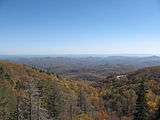
View overlooking Gragg, NC from the Stack Rock Creek Bridge on the Blue Ridge Parkway (mile marker 304.5)
-

Stack Rock Creek Bridge at Blue Ridge Parkway mile marker 304.5
See also
External links
References
Municipalities and communities of Avery County, North Carolina, United States | ||
|---|---|---|
| Towns | 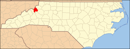 | |
| Villages | ||
| Unincorporated communities | ||
| Footnotes | ‡This populated place also has portions in an adjacent county or counties | |
This article is issued from Wikipedia - version of the 5/18/2016. The text is available under the Creative Commons Attribution/Share Alike but additional terms may apply for the media files.