Grade I listed buildings in Essex

Essex shown in England
There are over 9000 Grade I listed buildings in England. This page is a list of these buildings in the county of Essex.
Basildon
| Name | Location | Type | Completed [note 1] | Date designated | Grid ref.[note 2] Geo-coordinates |
Entry number [note 3] | Image |
|---|---|---|---|---|---|---|---|
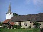
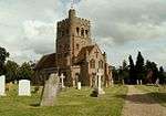
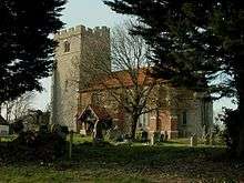
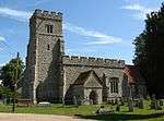
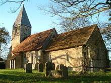
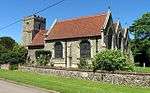
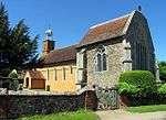
| Church of St Mary Magdalene | Great Burstead | Church | 14th century | 4 July 1955 | TQ6806592239 51°36′14″N 0°25′32″E / 51.603911°N 0.425462°E |
1122255 |  |
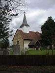
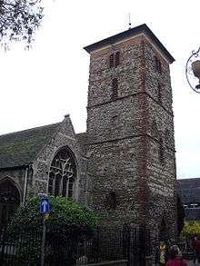
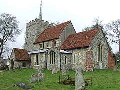
| Church of St Nicholas | Laindon | Church | 14th century | 24 March 1950 | TQ6879289515 51°34′45″N 0°26′05″E / 51.579223°N 0.43464°E |
1338377 |  |
Braintree
| Name | Location | Type | Completed [note 1] | Date designated | Grid ref.[note 2] Geo-coordinates |
Entry number [note 3] | Image |
|---|---|---|---|---|---|---|---|
| Parish Church of St Barnabas | Alphamstone, Braintree | Parish church | 12th century | 12 November 1984 | TL8787835461 51°59′09″N 0°44′05″E / 51.985826°N 0.734625°E |
1122865 |  |
| Parish Church of St Augustine of Canterbury | Ashen, Essex | Parish church | 13th century | 21 June 1962 | TL7473642321 52°03′06″N 0°32′49″E / 52.051727°N 0.546951°E |
1123044 |  |
| Church of St Peter and St Paul | Bardfield Saling, Braintree | Parish church | Decorated | 2 December 1967 | TL6861326514 51°54′42″N 0°27′00″E / 51.911636°N 0.449981°E |
1122802 |  |
| Church of St Ethelbert and All Saints | Belchamp Otten, Braintree | Church | c.1130 | 21 June 1962 | TL8033141765 52°02′42″N 0°37′41″E / 52.044942°N 0.628164°E |
1122381 |  |
| Barn about 50m South West of Paul's Hall | Belchamp St. Paul, Braintree | Barn | c.1200 | 17 May 1984 | TL7972643407 52°03′36″N 0°37′13″E / 52.059886°N 0.620215°E |
1122396 | 
|
| Church of St Andrew | Belchamp St. Paul, Braintree | Parish church | Mid-15th century | 21 June 1962 | TL7983343460 52°03′37″N 0°37′18″E / 52.060327°N 0.621802°E |
1166368 | 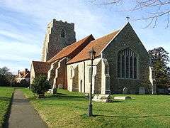 |
| Parish Church of St Mary the Virgin | Belchamp Walter, Braintree | Parish church | 13th century | 21 June 1962 | TL8274440700 52°02′05″N 0°39′46″E / 52.034588°N 0.662741°E |
1337867 |  |
| Baythorne Hall | Baythorne End, Birdbrook, Braintree | House | 16th century | 7 August 1952 | TL7194742659 52°03′20″N 0°30′23″E / 52.055634°N 0.506488°E |
1338344 |
|
| Stanton's Farmhouse | Black Notley, Braintree | Farmhouse | 15th century | 2 May 1953 | TL7686019813 51°50′56″N 0°33′59″E / 51.848893°N 0.566322°E |
1122817 |
|
| Parish Church (dedication unknown) | Borley, Braintree | Parish church | 11th century | 21 June 1962 | TL8475443065 52°03′19″N 0°41′36″E / 52.055162°N 0.693287°E |
1169675 |  |
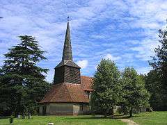
| Parish Church of the Holy Trinity | Bradwell, Braintree | Parish church | Early 12th century | 21 December 1967 | TL8177922156 51°52′06″N 0°38′20″E / 51.868358°N 0.638889°E |
1337594 |  |
| Parish Church of St Andrew | Bulmer | Parish church | 12th century | 21 June 1962 | TL8435340114 52°01′44″N 0°41′09″E / 52.028793°N 0.685855°E |
1169705 | 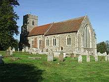 |
| Church of St Nicholas | Castle Hedingham, Braintree | Parish church | c.1180 | 21 June 1962 | TL7846935604 51°59′25″N 0°35′52″E / 51.99021°N 0.597834°E |
1338048 |  |
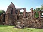
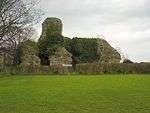
| Hedingham Castle | Castle Hedingham, Braintree | Bailey | 1130–40 | 7 August 1952 | TL7870635868 51°59′33″N 0°36′05″E / 51.992505°N 0.60142°E |
1122959 |  |
| Abbey Mill | Coggeshall, Braintree | Silk mill | 1820 | 2 May 1953 | TL8554622145 51°52′01″N 0°41′37″E / 51.86702°N 0.693533°E |
1168354 |  |
| Church of St Nicholas, Coggeshall Abbey | Coggeshall, Braintree | Abbey chapel | 1140–1538 | 31 October 1966 | TL8536722279 51°52′06″N 0°41′28″E / 51.868283°N 0.691008°E |
1337925 |  |
| Coggeshall Abbey (residence) | Coggeshall, Braintree | House | 1518–28 | 2 May 1953 | TL8553722244 51°52′04″N 0°41′36″E / 51.867912°N 0.693456°E |
1307099 |  |
| Guest House of Coggeshall Abbey | Coggeshall, Braintree | Guest house/boiler house | c.1190 | 2 May 1953 | TL8553522207 51°52′03″N 0°41′36″E / 51.86758°N 0.693407°E |
1307071 | 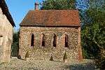 |
| The Abbot's Lodging and Corridor of Coggeshall Abbey | Coggeshall, Braintree | House | Late 16th century | 2 May 1953 | TL8552922241 51°52′04″N 0°41′36″E / 51.867888°N 0.693338°E |
1123191 |
|
| Parish Church of St Peter Ad Vincula | Coggeshall, Braintree | Church | 15th century | 31 October 1966 | TL8535023016 51°52′30″N 0°41′28″E / 51.874907°N 0.691157°E |
1337953 |  |
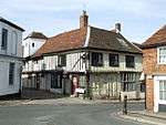
| Paycocke's | Coggeshall, Braintree | Jettied house | 15th century | 2 May 1953 | TL8479022501 51°52′14″N 0°40′58″E / 51.870468°N 0.682756°E |
1337597 |  |
| The Grange Barn | Coggeshall, Braintree | Grange barn | C12/early 13th century | 31 October 1966 | TL8490322220 51°52′04″N 0°41′03″E / 51.867907°N 0.684245°E |
1123112 | |
| Parish Church of St Andrew | Colne Engaine, Braintree | Parish church | C12-early 16th century | 21 June 1962 | TL8502630365 51°56′28″N 0°41′25″E / 51.941016°N 0.690399°E |
1123236 |  |
| Parish Church of All Saints | Cressing, Braintree | Parish church | 12th century | 21 December 1967 | TL7942620435 51°51′13″N 0°36′14″E / 51.853662°N 0.603858°E |
1337619 |  |
| The Barley Barn, 40m North West of Cressing Temple Farmhouse | Cressing, Braintree | Barn | Early 16th century | 2 May 1953 | TL7989318774 51°50′19″N 0°36′35″E / 51.838593°N 0.609767°E |
1123865 |  |
| The Wheat Barn, 35 Metres North East of Cressing Temple Farmhouse | Cressing, Braintree | Barn | Early 16th century | 2 May 1953 | TL7994218771 51°50′19″N 0°36′38″E / 51.83855°N 0.610476°E |
1123866 | 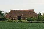 |
| Parish Church of St Andrew | Earls Colne, Braintree | Parish church | 13th century | 21 June 1962 | TL8606628826 51°55′37″N 0°42′17″E / 51.926848°N 0.704679°E |
1337907 |  |
| Parish Church of St Mary the Virgin | Fairstead, Essex | Church | 16th century | 21 December 1967 | TL7678516689 51°49′15″N 0°33′49″E / 51.820857°N 0.56364°E |
1337780 |  |
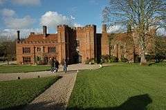
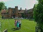
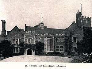
| Faulkbourne Hall | Faulkbourne, Braintree | Country house | Early 15th century | 2 May 1953 | TL8026816434 51°49′03″N 0°36′50″E / 51.817455°N 0.613987°E |
1337782 |  |
| Parish Church of St Germanus | Faulkbourne, Braintree | Parish church | 12th century | 21 December 1967 | TL8003016573 51°49′08″N 0°36′38″E / 51.81878°N 0.61061°E |
1337803 | 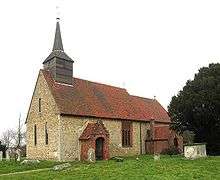 |
| Parish Church of All Saints | Feering, Braintree | Parish church | C12/13 | 21 December 1967 | TL8722020417 51°51′03″N 0°43′01″E / 51.850942°N 0.716882°E |
1123841 |  |
| Parish Church of St John the Baptist | Finchingfield, Braintree | Parish church | C12-C14 | 21 December 1967 | TL6862432806 51°58′05″N 0°27′12″E / 51.968151°N 0.453223°E |
1122729 |  |
| Spains Hall | Finchingfield, Braintree | House | 17th century | 2 May 1953 | TL6787634017 51°58′45″N 0°26′35″E / 51.979255°N 0.442937°E |
1138980 |  |
| The Guildhall | Finchingfield, Braintree | Apartment | 1985 | 21 December 1967 | TL6858032814 51°58′06″N 0°27′09″E / 51.968236°N 0.452587°E |
1115594 |  |
| Church of St Mary the Virgin | Gestingthorpe, Braintree | Parish church | 13th century | 21 June 1962 | TL8122038562 52°00′57″N 0°38′22″E / 52.015886°N 0.639418°E |
1123078 |  |
| Church of St Catherine | Gosfield, Braintree | Parish church | C15/C16 | 21 June 1962 | TL7778129403 51°56′05″N 0°35′05″E / 51.934736°N 0.584618°E |
1338075 |  |
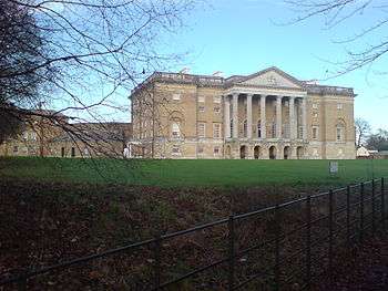
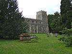
| Gosfield Hall | Gosfield, Braintree | House | Mid-16th century | 1 August 1946 | TL7751229713 51°56′15″N 0°34′51″E / 51.937606°N 0.580869°E |
1122938 |  |
| Barn Approximately 45 Metres East of Great Lodge | Great Bardfield, Braintree | Barn | Early 16th century | 2 May 1953 | TL6948929061 51°56′03″N 0°27′50″E / 51.934249°N 0.463957°E |
1335863 |
|
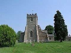
| Parish Church of St Mary the Virgin | Great Bardfield, Braintree | Parish church | 12th century | 21 December 1967 | TL6780030368 51°56′47″N 0°26′24″E / 51.9465°N 0.44005°E |
1123494 |  |
| Church of St Giles | Great Maplestead, Braintree | Parish church | 12th century | 21 June 1962 | TL8081734570 51°58′49″N 0°37′53″E / 51.980165°N 0.631448°E |
1337989 |  |
| Parish Church of St Andrew | Great Yeldham, Braintree | Parish church | c.1350 | 21 June 1962 | TL7577838667 52°01′07″N 0°33′37″E / 52.018578°N 0.560255°E |
1123010 |  |
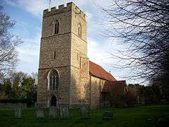
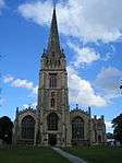
| Parish Church of St Andrew | Halstead, Braintree | Parish church | 14th century | 24 February 1950 | TL8152330691 51°56′42″N 0°38′23″E / 51.945097°N 0.639667°E |
1338284 | 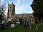 |
| Parish Church of St Mary | Kelvedon, Braintree | Parish church | Early 12th century | 21 December 1967 | TL8564518566 51°50′05″N 0°41′35″E / 51.834844°N 0.693049°E |
1337631 |  |
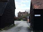
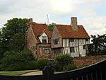
| 1–5 High Street | Kelvedon, Braintree | Abbots summer palace | Early 16th century | 21 December 1967 | TL8590518429 51°50′01″N 0°41′48″E / 51.833527°N 0.696745°E |
1123814 | _High_Street%2C_Kelvedon_(geograph_4355485).jpg) |
| Parish Church of the Holy Innocents | Lamarsh, Braintree | Parish church | Early 12th century or earlier | 21 June 1962 | TL8898136059 51°59′27″N 0°45′04″E / 51.990822°N 0.750997°E |
1166331 |  |
| Parish Church (dedication unknown) | Liston, Braintree | Parish church | Early 12th century | 21 June 1962 | TL8527444782 52°04′13″N 0°42′06″E / 52.070408°N 0.701793°E |
1122335 |  |
| Church of All Saints | Middleton, Braintree | Parish church | Mid-12th century | 21 June 1962 | TL8709639675 52°01′26″N 0°43′32″E / 52.023933°N 0.72555°E |
1123271 | 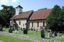 |
| Panfield Hall | Panfield, Braintree | Great house | 16th century | 2 May 1953 | TL7399425029 51°53′48″N 0°31′39″E / 51.896644°N 0.527383°E |
1337833 |
|
| Parish Church of St John the Baptist | Pebmarsh, Braintree | Parish church | Earlier origin | 21 June 1962 | TL8536733489 51°58′08″N 0°41′49″E / 51.968958°N 0.697038°E |
1146603 |  |
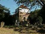
| Church of St Gregory and St George | Pentlow, Braintree | Parish church | 12th century | 21 June 1962 | TL8127246162 52°05′03″N 0°38′39″E / 52.084125°N 0.644203°E |
1232662 |  |
| Church of All Saints | Rayne Hall Green, Rayne, Braintree | Parish church | c.1510 | 21 December 1967 | TL7330922913 51°52′40″N 0°30′59″E / 51.877851°N 0.516375°E |
1308377 |  |
| Parish Church of St Laurence | Ridgewell, Braintree | Parish church | 14th century and 15th century | 21 June 1962 | TL7399240908 52°02′21″N 0°32′07″E / 52.039269°N 0.535393°E |
1165620 | 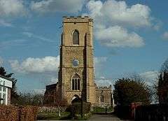 |
| Church of St Mary and All Saints | Rivenhall, Braintree | Parish church | 10th century | 1 March 1950 | TL8280017791 51°49′44″N 0°39′05″E / 51.828821°N 0.651396°E |
1169594 | 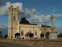 |
| Parish Church of St Andrew | Shalford, Braintree | Church | 12th century | 21 December 1967 | TL7239729245 51°56′06″N 0°30′23″E / 51.935009°N 0.506305°E |
1147647 | 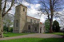 |
| Parish Church of St Peter and St Thomas | Stambourne, Braintree | Parish church | Late 11th century | 21 June 1962 | TL7210538858 52°01′17″N 0°30′25″E / 52.021444°N 0.506879°E |
1317130 |  |
| Moyns Park | Steeple Bumpstead, Braintree | Country house | Late 16th century | 7 August 1952 | TL6943840621 52°02′17″N 0°28′08″E / 52.0381°N 0.468921°E |
1338363 |  |
| Parish Church of St Mary the Virgin | Steeple Bumpstead, Braintree | Parish church | 11th century | 21 June 1962 | TL6790241055 52°02′33″N 0°26′48″E / 52.042466°N 0.446762°E |
1166315 |  |
| Parish Church of All Saints | Stisted, Braintree | Boundary stone | 17th century | 21 December 1967 | TL7987324601 51°53′27″N 0°36′45″E / 51.890935°N 0.612509°E |
1123870 |  |
| Parish Church of St Mary the Virgin | Sturmer, Braintree | Parish church | Early 11th century | 21 June 1962 | TL6902243899 52°04′04″N 0°27′52″E / 52.067671°N 0.464483°E |
1122274 |  |
| Ringers Farmhouse | Terling, Braintree | Farmhouse | Early 16th century | 2 May 1953 | TL7617113334 51°47′27″N 0°33′11″E / 51.790916°N 0.553037°E |
1123406 |
|
| Parish Church of St Maragret | Tilbury Juxta Clare, Braintree | Parish church | 15th century | 21 June 1962 | TL7595540290 52°01′59″N 0°33′49″E / 52.0331°N 0.563665°E |
1122987 | 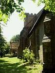 |
| Parish Church of St Margaret of Antioch | Toppesfield, Braintree | Parish church | c.1300 | 21 June 1962 | TL7396337447 52°00′29″N 0°32′00″E / 52.008192°N 0.533213°E |
1165328 | 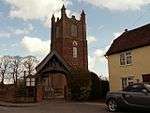 |
| Parish Church of St Mary Magdalene | Wethersfield, Braintree | Parish church | 12th century | 21 December 1967 | TL7122131250 51°57′12″N 0°29′25″E / 51.953381°N 0.490214°E |
1337860 | 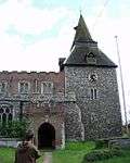 |
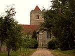
| Church of St Ethelreda | White Notley, Braintree | Parish church | 11th century | 2 January 1985 | TL7854618236 51°50′03″N 0°35′24″E / 51.834193°N 0.58996°E |
1147914 |  |
| Church of St Nicolas | Witham, Braintree | Parish church | 14th century Additions | 1 March 1950 | TL8172915378 51°48′27″N 0°38′05″E / 51.807498°N 0.634606°E |
1338236 |  |
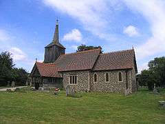
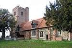
| Church of St Mary the Virgin | Church Street, Bocking, Braintree | Parish church | 14th century | 25 October 1951 | TL7568925684 51°54′07″N 0°33′08″E / 51.901996°N 0.552325°E |
1122530 |  |
| Bocking Windmill | Church Street, Bocking, Braintree | Post mill | c.1680 | 25 October 1951 | TL7630725967 51°54′16″N 0°33′41″E / 51.904343°N 0.561443°E |
1122492 | 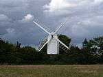 |
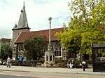
Brentwood


May2003.jpg)


Castle Point
| Name | Location | Type | Completed [note 1] | Date designated | Grid ref.[note 2] Geo-coordinates |
Entry number [note 3] | Image |
|---|---|---|---|---|---|---|---|
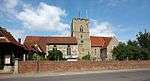
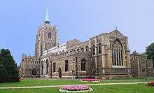
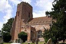
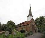
| Church of St James the Less | Hadleigh | Parish church | Mid-12th century | 7 August 1952 | TQ8101287025 51°33′11″N 0°36′34″E / 51.553069°N 0.60953°E |
1337692 | 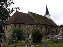 |
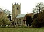
| Church of St Mary the Virgin | South Benfleet | Parish church | 12th century | 7 August 1952 | TQ7782986138 51°32′46″N 0°33′48″E / 51.546114°N 0.56322°E |
1123690 |  |
| Hadleigh Castle | Castle Point | Castle | Early 13th century | 7 August 1952 | TQ8097886090 51°32′41″N 0°36′31″E / 51.544682°N 0.608559°E |
1123687 | 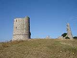 |
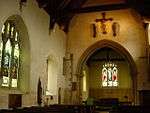
Chelmsford
.jpg)


Colchester


_2013-09-02_23-05-18.jpg)


Epping Forest


_-_geograph.org.uk_-_654763.jpg)

.jpg)

.jpg)
Harlow
| Name | Location | Type | Completed [note 1] | Date designated | Grid ref.[note 2] Geo-coordinates |
Entry number [note 3] | Image |
|---|---|---|---|---|---|---|---|
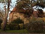
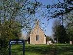
| Chapel South West of Harlowbury in Grounds | Harlow | Chapel | c1170/1180 | 5 July 1950 | TL4772912056 51°47′16″N 0°08′26″E / 51.787662°N 0.140431°E |
1111694 |  |
| Church of St Andrew | Netteswellbury Farm, Harlow | Church/Learning Centre | 13th century | 5 July 1950 | TL4561109349 51°45′50″N 0°06′31″E / 51.763895°N 0.108611°E |
1111692 |  |
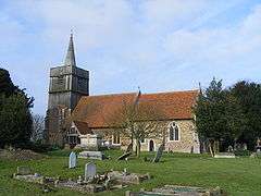
| Church of St Mary the Virgin | Latton, Harlow | Parish church | 12th century | 5 July 1950 | TL4640410881 51°46′39″N 0°07′15″E / 51.777453°N 0.120739°E |
1337049 |  |
| Church of St Mary the Virgin | Great Parndon, Harlow | Church | 15th century | 5 July 1950 | TL4323908906 51°45′38″N 0°04′27″E / 51.760525°N 0.074081°E |
1337051 |  |
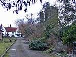
| Harlowbury | Harlow | Abbots summer palace | 13th century | 16 June 1977 | TL4774512096 51°47′17″N 0°08′26″E / 51.788017°N 0.140679°E |
1306455 | |
Maldon


.jpg)
.jpg)


Rochford
| Name | Location | Type | Completed [note 1] | Date designated | Grid ref.[note 2] Geo-coordinates |
Entry number [note 3] | Image |
|---|---|---|---|---|---|---|---|
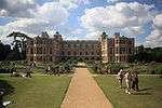
| Rochford Hall and ruins | Rochford, Rochford District | House | 16th century | 4 December 1951 | TQ8706890336 51°34′51″N 0°41′55″E / 51.580833°N 0.69854°E |
1112586 |  |
Southend-on-Sea
| Name | Location | Type | Completed [note 1] | Date designated | Grid ref.[note 2] Geo-coordinates |
Entry number [note 3] | Image |
|---|---|---|---|---|---|---|---|
| Church of St Laurence and All Saints | Eastwood, Southend-on-Sea | Church | 12th century | 23 November 1951 | TQ8616488842 51°34′04″N 0°41′05″E / 51.567714°N 0.684717°E |
1322331 |  |
| Church of St Mary | Prittlewell, Southend-on-Sea | Church | 12th century | 23 November 1951 | TQ8768286822 51°32′57″N 0°42′20″E / 51.549069°N 0.705517°E |
1322353 |  |
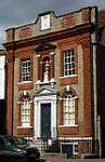
| Porters (Civic House) | Prittlewell, Southend-on-Sea | Manor House | Late 15th century or early 16th century | 23 November 1951 | TQ8861085837 51°32′24″N 0°43′06″E / 51.539913°N 0.718357°E |
1112724 |
|
| Prittlewell Priory | Prittlewell, Southend-on-Sea | Priory | 12th century | 23 November 1951 | TQ8764587336 51°33′13″N 0°42′19″E / 51.553697°N 0.705258°E |
1112719 | 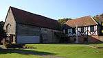 |
| Southchurch Hall | Southchurch, Southend-on-Sea | Cross Wing House | 13th century | 23 November 1951 | TQ8939885523 51°32′13″N 0°43′46″E / 51.536829°N 0.729538°E |
1306880 |  |
Tendring


.jpg)


Thurrock
| Name | Location | Type | Completed [note 1] | Date designated | Grid ref.[note 2] Geo-coordinates |
Entry number [note 3] | Image |
|---|---|---|---|---|---|---|---|
| Church of St Clement | West Thurrock, Thurrock | Church | c.1200 | 8 February 1960 | TQ5931377298 51°28′20″N 0°17′33″E / 51.47222°N 0.292439°E |
1147660 |  |
| Church of St Giles and All Saints | Orsett, Thurrock | Church | 12th century | 8 February 1960 | TQ6444081971 51°30′46″N 0°22′06″E / 51.512736°N 0.368367°E |
1147049 | 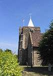 |
| Church of St Katherine | East Tilbury, Thurrock | Church | 12th century | 8 February 1960 | TQ6890776964 51°27′59″N 0°25′49″E / 51.466439°N 0.430286°E |
1337129 |  |
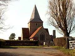
| Church of St Margaret of Antioch | Stanford-le-Hope, Thurrock | Church | 12th century | 8 February 1960 | TQ6843882264 51°30′51″N 0°25′34″E / 51.514191°N 0.426068°E |
1111653 |  |
| Church of St Mary | Bulphan, Thurrock | Church | Late 15th century | 8 February 1960 | TQ6367885834 51°32′52″N 0°21′33″E / 51.547661°N 0.35919°E |
1111617 |  |
| Church of St Mary | Corringham, Thurrock | Church | 11th century | 8 February 1960 | TQ7098683289 51°31′21″N 0°27′48″E / 51.522634°N 0.463249°E |
1337083 | 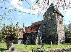 |
| Church of St Mary | Chadwell St Mary, Thurrock | Church | Early 12th century | 8 February 1960 | TQ6462778498 51°28′53″N 0°22′10″E / 51.481481°N 0.369441°E |
1111576 |  |
| Church of St Mary the Virgin | Stifford, Thurrock | Church | 12th century | 8 February 1960 | TQ6045480308 51°29′56″N 0°18′37″E / 51.49894°N 0.31022°E |
1111611 | 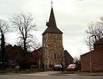 |
| Church of St Michael | Fobbing, Thurrock | Church | 11th century | 8 February 1960 | TQ7180183898 51°31′40″N 0°28′31″E / 51.527858°N 0.475282°E |
1146807 |  |
| Church of St Michael | Aveley, Thurrock | Church | 12th century | 8 February 1960 | TQ5675880088 51°29′53″N 0°15′25″E / 51.498°N 0.25692°E |
1337099 | _-_geograph.org.uk_-_36157.jpg) |
| Church of St Nicholas | South Ockendon, Thurrock | Church | 12th century | 8 February 1960 | TQ5950082908 51°31′21″N 0°17′52″E / 51.522569°N 0.297663°E |
1111564 |  |
| Church of St Peter and St Paul | Horndon on the Hill, Thurrock | Church | 13th century | 8 February 1960 | TQ6692583298 51°31′26″N 0°24′17″E / 51.523929°N 0.404773°E |
1337109 | 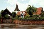 |
| Government Powder Magazine | Purfleet, Thurrock | Powder Magazine | 1763 to 1765 | 10 November 1981 | TQ5488478518 51°29′04″N 0°13′45″E / 51.48441°N 0.229256°E |
1166258 | 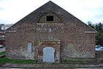 |
Uttlesford


.jpg)
.jpg)


See also
- Category:Grade I listed buildings in Essex
- Grade II* listed buildings in Essex
Notes
- 1 2 3 4 5 6 7 8 9 10 11 12 13 14 The date given is the date used by Historic England as significant for the initial building or that of an important part in the structure's description.
- 1 2 3 4 5 6 7 8 9 10 11 12 13 14 Sometimes known as OSGB36, the grid reference is based on the British national grid reference system used by the Ordnance Survey.
- 1 2 3 4 5 6 7 8 9 10 11 12 13 14 The "List Entry Number" is a unique number assigned to each listed building and scheduled monument by Historic England.
External links
![]() Media related to Grade I listed buildings in Essex at Wikimedia Commons
Media related to Grade I listed buildings in Essex at Wikimedia Commons
This article is issued from Wikipedia - version of the 12/2/2016. The text is available under the Creative Commons Attribution/Share Alike but additional terms may apply for the media files.