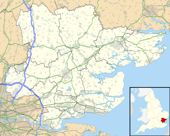
Fairstead, Essex
| Fairstead, Essex | |
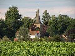 Hall Farm and Fairstead Church |
|
 Fairstead, Essex |
|
| Population | 290 (2011 Census)[1] |
|---|---|
| Civil parish | Fairstead |
| District | Braintree, Essex |
| Shire county | Essex |
| Region | East |
| Country | England |
| Sovereign state | United Kingdom |
| Post town | Chelmsford |
| Postcode district | CM3 |
| Dialling code | 01245 |
| Police | Essex |
| Fire | Essex |
| Ambulance | East of England |
| EU Parliament | East of England |
Coordinates: 51°49′24″N 0°33′56″E / 51.823434°N 0.565517°E
Fairstead is a civil parish in the Braintree district of Essex. Whilst isolated in a community of farming hamlets, the parish of Fairstead has close connections with Great Leighs and is 9.8 miles (15.8 km) from Chelmsford, Essex's capital. The parish encompasses the hamlets of Fuller Street & Ranks Green. Fairstead (including Faulkbourne) had a population of 290 according to the 2011 census.[1] In the 1870s, Fairstead was described as being:
- "a parish in Witham district, Essex; 2¼ miles SW of White Notley r. station, and 4 WNW of Witham."[2]
Meaning of name
The name 'Fairstead' originates from Old English, meaning 'fair place'.[3] Fair (fæger) meaning fair, beautiful or pleasant.[3] Stead (stede) meaning 'A place, a site, a locality; a religious house or foundation; a place of communal activity; a farm, a dairy-farm, an estate.'[3]
Population
In the Domesday Book of 1086, Fairstead had a total population of "17 households".[4]
The population of Fairstead has increased 90 since the introduction of the census in 1801. Other than a peak increase of 150 in 1831, increasing the population to 350, which over the next few decades fell to 250 and levelled off, the population of Fairstead hasn't risen or fallen significantly.
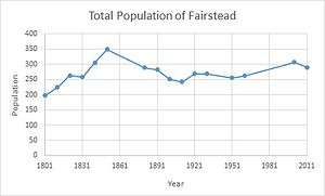
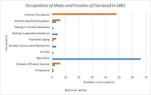
In 1881, Fairstead's population was predominately male, with men outnumbering women 82:64. The majority of males listed their occupation as working in agriculture, with 66 of the males working as farmers or a similar occupation. 48 of the 66 women in Fairstead were listed as "Unknown Occupation", this possibly indicate that they worked at home or were housewives.
According to the 2011 Census, there are 133 households in Fairstead, accommodating 290 people; 158 males 132 females.[5] Of these 290 people, 156 are in work. The majority of the workers, 33 (21.2%) are in senior positions, such as managers and directors. Unlike in previous decades, few people are employed in the agriculture industry, only 10 people (6.4%) are employed in this industry.[6]
Education
In 1818, the education in Fairstead consisted of, "A day school, supported at the expense of the rector, containing 20 children. The poor have ample means of educating children."[7] Education had developed by 1833, with Fairstead having "One Day and Sunday School, supported by the Rector, in which 22 males and 18 females attend daily, and 12 males and 4 females in addition on Sundays."[8] By 1867 attendance and facilities had increased:
- "There is both a day and night school in Fairstead, not in connexion with Government, held in a large room in a cottage, attended by from 40 to 50 children. The night school is taught by the rector, with the aid of the school-mistress."[9]
Nowadays the nearest primary and secondary schools are located in; Great Leighs, Terling and White Notley. A lack of higher and further education is indicated as 23% of over 16's have no formal qualifications. Whereas 13.5% of 16's have 5 or more GCSE's (A*-C).[5]
Present
The nearest town is Witham, approximately 4 mi (6.4 km) to the south-east, followed by Braintree, approximately 5 mi (8 km) to the north. Train services are available from nearby White Notley and Cressing, on the Braintree Branch Line. Trains to London take between 45 minutes and an hour, terminating at Liverpool Street.
There are no sport clubs in Fairstead, the nearest sport clubs are in; Braintree, Witham and Chelmsford. Most notably, Braintree Town F.C who play football in the Conference and Chelmsford City F.C who play football in the Conference South.
The Square and Compassess pub dates back to 1652, it was originally two farming cottages.
Fairstead sits on the Essex Way, a popular 81-mile waymarked long-distance footpath.
References
- 1 2 "Fairstead (Parish): Key Figures for 2011 Census: Key Statistics". Neighbourhood Statistics. Office for National Statistics. Retrieved 27 January 2015.
- ↑ Wilson, John Marius (1870). Gazetter of England and Wales. Edinburgh: A. Fullerton & Co. Retrieved 27 January 2015.
- 1 2 3 "Key to English Place-Names". The University of Nottingham. Retrieved 23 February 2015.
- ↑ "Open Domesday". Domesday Map. Retrieved 26 February 2015.
- 1 2 "Lead Key Figures Fairstead". Neighbourhood Statistics. Office of National Statistics. Retrieved 16 March 2015.
- ↑ "2011 Occupation Data". Neighbourhood Statistics. Office for National Statistics. Retrieved 20 April 2015.
- ↑ Great Britain. Parliament., House of Commons (1819). A Digest of Parochial Returns Made to the Select Committee Appointed to Inquire Into the Education of the Poor (1818). Irish University Press.
- ↑ Great Britain. Parliament, House of Commons (1833). "House of Commons Papers". 42.
- ↑ Great Britain. Parliament, House of Commons (1868). "Reports from Commissioners".
External links
![]() Media related to Fairstead, Essex at Wikimedia Commons
Media related to Fairstead, Essex at Wikimedia Commons