Quendon and Rickling
Quendon and Rickling is a civil parish in the Uttlesford district of Essex, England with an area of 2,048 acres.[1] The population of the civil parish at the 2011 was 587.[2] It is a linear settlement on the B1383 (formerly the A11 trunk road) between Saffron Walden and Bishops Stortford.[3] Quendon & Rickling stand 300 feet above sea level on a watershed between two rivers: the Cam to the east, flowing north through Cambridge to the Ouse flowing on to the Wash.[4]
Etymology
The parish and its name were created in the 1940s by the merger of Quendon and Rickling parishes.[5] The name Quendon derives from the Old English 'cwene' and 'den' which means the ‘women’s valley’. Rickling originates from Ricola, the Queen of Essex in the 6th Century.
History
People were living in the area over ten thousand years ago because of the Neolithic and Palaeolithic remains found. The village of Rickling was mentioned in the Doomsday Book of 1086. In circa 1200 the churches of the parish were built.
Both villages are known for their halls: Quendon Hall and Rickling Hall, where until the 1960s most of the parish was employed to work the farms of the estates. The parish mostly consists of 17th Century housing; between 1951 and 1961 the number of houses increased from 171 to only 172.[6] This is shown by the attempts to create a conseration area.[7] The population was recorded at 557 in the 1951 census, decreasing to 514 by 2001.[8]
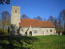
The conjoined settlement contains two churches: St Simon & St Jude, Quendon and All Saints, Rickling, which are both over 800 years old.
See also
References
- ↑ "Vision of Britain | 1961 Census: County Report | Table 3". www.visionofbritain.org.uk. Retrieved 22 May 2015.
- ↑ "Civil Parish population 2011". Retrieved 27 September 2015.
- ↑ "local history of quendon and rickling villages in essex report". www.recordinguttlesfordhistory.org.uk. Retrieved 22 May 2015.
- ↑ "Quendon and Rickling Parish | A Brief History of Quendon & Rickling Village". www.quendonandrickling.co.uk. Retrieved 22 May 2015.
- ↑ Quendon and Rickling CP Essex through time | Administrative history of Parish-level Unit: hierarchies, boundaries Archived September 23, 2006, at the Wayback Machine.
- ↑ "Quendon and Rickling CP through time |Housing Statistics | Total Houses". www.visionofbritain.org.uk. Retrieved 22 May 2015.
- ↑ "Uttlesford District Council - Quendon and Rickling Conservation Area Appraisal". uttlesford-consult.limehouse.co.uk. Retrieved 22 May 2015.
- ↑ "Quendon and Rickling CP through time | Population Statistics |Total Population". www.visionofbritain.org.uk. Retrieved 22 May 2015.
Coordinates: 51°57′00″N 0°11′56″E / 51.950°N 0.199°E