Grade II listed buildings in Brighton and Hove: A–B
.jpg)
As of February 2001, there were 1,124 listed buildings with Grade II status in the English city of Brighton and Hove.[2] The total at 2009 was similar.[3] The city, on the English Channel coast approximately 52 miles (84 km) south of London, was formed as a unitary authority in 1997 by the merger of the neighbouring towns of Brighton and Hove. Queen Elizabeth II granted city status in 2000.[4]
In England, a building or structure is defined as "listed" when it is placed on a statutory register of buildings of "special architectural or historic interest" by the Secretary of State for Culture, Media and Sport, a Government department, in accordance with the Planning (Listed Buildings and Conservation Areas) Act 1990.[5] English Heritage, a non-departmental public body, acts as an agency of this department to administer the process and advise the department on relevant issues.[6] There are three grades of listing status. The Grade II designation is the lowest, and is used for "nationally important buildings of special interest".[7] Grade II* is used for "particularly important buildings of more than special interest";[7] there are 69 such buildings in the city. There are also 24 Grade I listed buildings (defined as being of "exceptional interest" and greater than national importance, and the highest of the three grades)[7] in Brighton and Hove.
This list summarises 123 Grade II-listed buildings and structures whose names begin with A or B. Numbered buildings with no individual name are listed by the name of the street they stand on. Some listings include contributory fixtures such as surrounding walls or railings in front of the building. These are summarised by notes alongside the building name.
Listed buildings
| Note | Listing includes |
| [A] | Attached railings |
| [B] | Attached walls |
| [C] | Attached walls and piers |
| [D] | Attached walls and railings |
| [E] | Attached walls, gates and railings |
| [F] | Attached walls, piers and railings |
| [G] | Attached walls, piers, railings and lamps |
| Building name | Area | Image | Notes | Refs |
| Abbey Hotel | Montpelier 50°49′38″N 0°09′14″W / 50.8272°N 0.1539°W | .jpg) | Norfolk Terrace was developed piecemeal in the 1850s. A terrace of six five-storey houses, stuccoed, bay-fronted and with moulded architraves and pediments, were converted into a hotel and show consequent alterations. The hotel has subsequently been turned into bedsits. A cornice with dentil decoration runs across the building below the roof. | [8][9] [10] |
| 17 and 19 Abbey Road[D] | Kemptown 50°49′09″N 0°07′11″W / 50.8192°N 0.1197°W | .jpg) | These stucco-faced, slate-roofed terraced houses also face Great College Street, and present a three-window façade to it. Built in the Italianate style, and once lived in by former mayor Henry Abbey, the mid-19th-century houses have porches with piers, pilasters and bracketed cornices with rusticated decoration. | [11] |
| Adelaide Mansions | Hove 50°49′28″N 0°09′57″W / 50.8244°N 0.1658°W | .jpg) | This four-house terrace dates from 1873. The roofline, hiding attic space, has a parapet with balustrades, and the whole four-storey building is faced with stucco with brick underneath. The windows vary between segment-headed and pediment-topped, and between the casement and sash styles. The porches have Doric columns. | [12] |
| 2 and 4 Albany Villas[D] | Hove 50°49′32″N 0°10′24″W / 50.8255°N 0.1734°W | .jpg) | The main point of interest in these 1850s semi-detached villas is the semicircle-headed dormers in the attic. Prominent quoins show the divide between the houses; the façade is entirely stuccoed. The hipped roof has large bracketed eaves. | [13] |
| 3 and 5 Albany Villas | Hove 50°49′31″N 0°10′22″W / 50.8254°N 0.1729°W | .jpg) | With their stucco-faced brickwork, wide quoins, sash windows, side porches with pilasters and steps, deep eaves and slate roof, these villas are similar to the contemporary pair and 2 and 4 Albany Villas opposite. | [14] |
| Albemarle Mansions[C] | Hove 50°49′30″N 0°10′30″W / 50.8249°N 0.1751°W | .jpg) | These three-storey flats on Kingsway, facing away from the sea, date from about 1870. A dentil cornice is topped by a parapet which obscures the roof; like the rest of the three-storey building, these features are stuccoed. The L-shaped plan consists of a five-bay northern façade and seven bays to the east. | [15] |
| All Saints Church: Vicarage | Hove 50°49′49″N 0°09′59″W / 50.8302°N 0.1663°W | .jpg) | John Loughborough Pearson, who designed the Grade I-listed church, added a vicarage in a different style in 1882–83. The Tudor–Gothic brick and Bath stone building has oriel and trefoil-headed mullioned and transomed windows. | [16][17] |
| 2, 3, 4, 8, 8a and 9 Arundel Place Mews | Kemp Town 50°48′59″N 0°06′32″W / 50.8163°N 0.1089°W | .jpg) | These formed the service areas for the east side of Lewes Crescent and Sussex Square in the Kemp Town development, and were built slightly later (between 1840 and 1860). The L-shaped mews present a three- and a four-window façade to a courtyard, with narrow doorways with high, arched fanlights. The hipped roof has large eaves and chimneys. | [18] |
| 11 and 12 Arundel Place Mews[C] | Kemp Town 50°48′58″N 0°06′32″W / 50.8160°N 0.1089°W | .jpg) | The architecture of this long two-storey stuccoed part of the mews, contemporary with the separately listed section nearby, has been called "Tuscan Vernacular Revival". Some original sash windows survive, and the lower storey resembles an arcade with its series of round-arched doors and openings. | [19] |
| Astoria Theatre (former) | Brighton 50°49′34″N 0°08′10″W / 50.8261°N 0.1362°W | .jpg) | Now a disused bingo hall, this Art Deco-style cinema opened in 1933 as an 1,800-capacity "super-cinema". It is steel-framed with brick walls and a 45-metre (148 ft) stone façade. The interior friezework is considered particularly impressive. The cinema closed in 1977, and bingo ceased in 1997. | [20][21] [22][23] |
| 1–5 Atlingworth Street[A] | Kemptown 50°49′10″N 0°07′47″W / 50.8195°N 0.1297°W | .JPG) | Number 1 in this terrace is taller and narrower, with one window on each of four full storeys. The others have two- or three-window ranges but only two storeys and an attic floor. Stucco, pilastered entrance porches and parapets give a Classical appearance. | [24][25] |
| 13–24 Atlingworth Street[A] | Kemptown 50°49′10″N 0°07′46″W / 50.8195°N 0.1294°W | .JPG) | The terrace, built in the 1820s, has a long series of bow windows; some original glazing and frames remain. The three- and four-storey houses have Tuscan order porches like their counterparts opposite. | [24][26] |
| Aubrey House | Rottingdean 50°48′23″N 0°03′33″W / 50.8065°N 0.0593°W |  | In 1889, Edward Burne-Jones commissioned an architect to refront this ancient house. W.A.S. Benson's work added three buttressed arcaded windows, wooden balconies in front of the roof and a long oriel window. Weatherboarding at the rear may have been added on behalf of Enid Bagnold, a later resident. | [27] |
| Baldwin Mausoleum at Brighton Extramural Cemetery | Bear Road 50°50′11″N 0°07′12″W / 50.8364°N 0.1201°W | .jpg) | Prolific Brighton architect John Leopold Denman designed this marble and stone tomb in a Byzantine Revival style for Edmund Baldwin. The cruciform structure has a dome and a columned entrance with a bronze door. | [28][29] |
| Banjo Groyne | Kemp Town 50°48′58″N 0°07′12″W / 50.8162°N 0.1201°W | .JPG) | Doubling as a groyne and a walkway for Victorian promenaders, this flint feature opposite Paston Place was built in the 1880s, when many improvements were made to the fixtures along Marine Parade. There have been later alterations. | [30][31] |
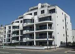
| Barford Court | Hove 50°49′35″N 0°10′58″W / 50.8264°N 0.1827°W | .jpg) | This was originally a private house; later uses were a school of nursing and a care home. Architect Robert Cromie, known mostly for cinemas, designed it in 1934–37 for iron-industry tycoon and film director Ian Stuart Millar. The severe, plain Neo-Georgian exterior, in Italian purple-grey brick, contrasts with the opulent Art Deco interior. | [32][33] [34] |
| Barn at Hillside | Rottingdean 50°48′25″N 0°03′36″W / 50.8069°N 0.0600°W | .JPG) | Hillside, a Grade II*-listed 18th-century house, has a contemporary barn to its southwest. The walls are of knapped flint, mostly laid in courses. The large entrance is weatherboarded. | [35] |
| Barn at Stanmer Park | Stanmer 50°52′16″N 0°06′07″W / 50.8710°N 0.1020°W | .jpg) | Built in the mid-18th century in the estate village of Stanmer, this "long barn" of 12 bays is a traditional Sussex design. Three walls are of flint, but one is weatherboarded on top of timber framing. The hipped roof has braces and queen posts inside. | [36][37] |
| 1 Bartholomews | The Lanes 50°49′16″N 0°08′24″W / 50.8210°N 0.1400°W | .JPG) | This 19th-century three-storey house is now in commercial use. The three-window range consists of large straight-headed sashes with prominent sills. The exterior is stuccoed. | [38] |
| 3 Bartholomews[A] | The Lanes 50°49′16″N 0°08′23″W / 50.8210°N 0.1398°W | .JPG) | A good example of Georgian architecture in central Brighton, this early-19th-century red-brick house now has a ground-floor shopfront inserted. On the first floor, a sash window is separated from tall, narrow openings by brick piers. The top floor has one large window and a dentil-patterned cornice above. | [39][40] |
| 4 Bartholomews | The Lanes 50°49′16″N 0°08′23″W / 50.8210°N 0.1397°W | .JPG) | This Georgian-style building, contemporary with its neighbours, has a three-window range and a narrow recessed fourth bay with blank windows to the right. The entrance is in this part, next to a modern shopfront. The red brick and stucco walls are topped by a parapet and a slate roof. | [39][41] |
| 5 and 6 Bartholomews[A] | The Lanes 50°49′16″N 0°08′23″W / 50.8210°N 0.1396°W | .jpg) | Although the buildings no longer look the same, they were built as a pair of red-brick four-storey houses. Number 6 had a fifth storey added in the late 19th century, and is now stuccoed. Number 5 has piano nobile windows on the first floor, with an iron balcony in front. They sit between Tuscan pilasters and an open pediment, as do the first-floor windows of number 6. | [39][42] |
| 6c Bartholomews | The Lanes 50°49′14″N 0°08′22″W / 50.8205°N 0.1395°W | .jpg) | This early-19th-century building presents façades to both East Street and Bartholomews. Both sides have a shopfront on the ground-floor and a single-window range to each of the three floors above. All are sashes of various sizes. The walls are stuccoed. | [43] |
| 7 Bartholomews | The Lanes 50°49′14″N 0°08′23″W / 50.8205°N 0.1396°W | .jpg) | This three-storey building, with a shop below two floors of flats, has a single-window range; the sash window on the top floor is smaller than that on the middle storey, but both have architraves and large sills. A cornice and parapet obscure the roof on the street-facing wall only. | [44] |
| 8 Bartholomews | The Lanes 50°49′13″N 0°08′22″W / 50.8204°N 0.1395°W | .jpg) | Also known as The Cottage, this tarred and cobbled house (now in commercial use) has 18th-century origins. Coating flints in pitch was a common weatherproofing technique in 18th- and 19th-century Brighton. The side wall is stuccoed and has a chimney. Below the roof is a dentil cornice interrupted by the upper-storey window lintels. | [45][46] |
| Bath Arms and 4 and 5 Meeting House Lane | The Lanes 50°49′16″N 0°08′28″W / 50.8211°N 0.1411°W | .jpg) | Like most of the surrounding buildings, this was an early-19th-century house. In 1864, it was remodelled to form a tall three-storey pub with living quarters above, which appears "gargantuan" in relation to the narrow lanes (Meeting House Lane and Union Street) it faces. The façades have two- and four-window ranges respectively, and there are three doorways—each flanked by pilasters. | [47][48] |
| Beacon Mill | Rottingdean 50°48′21″N 0°03′47″W / 50.8059°N 0.0630°W |  | Used for corn-milling from 1802 until 1881, this smock mill may have been used by smugglers signalling to ships at sea. Renovations in 1905, the 1930s, 1966 and 1975 have restored the landmark, on the 216 feet (66 m) Beacon Hill, to good condition. The base is of stone and brick; an octagonal weatherboarded body rises to three storeys above it. Sir William Nicholson's drawing of the mill was Heinemann's logo for many years. | [49][50] |
| 2 Bedford Place | Brighton 50°49′26″N 0°09′16″W / 50.8239°N 0.1545°W | .jpg) | This is a 3-storey end-of-terrace house of the mid-19th century. Stuccoed, with rusticated walls on the ground floor, it has bay windows and a dormer window above the cornice. | [51] |
| 4–7 Bedford Square[A] | Brighton 50°49′22″N 0°09′18″W / 50.8229°N 0.1550°W | .jpg) | Work on Bedford Square started in 1807, making it one of the earliest developments west of the old village centre. These four houses at the southwest corner have three floors, mansard roofs with dormers, bay windows and first-floor verandahs with iron railings. | [52][53] |
| 8 Bedford Square[A] | Brighton 50°49′23″N 0°09′18″W / 50.8231°N 0.1549°W | .jpg) | Building work on the square was mostly carried out in about 1810, but it was not finished until 1828. This house rises to four storeys and has two windows (including bays) with architraves on each floor, plus a dormer. An iron balcony at first-floor level is supported on decorative brackets. | [54][55] |
| 9 Bedford Square[A] | Brighton 50°49′24″N 0°09′18″W / 50.8232°N 0.1549°W | .jpg) | This house has four storeys but, unlike its neighbour at number 8, no dormer window. Except on the ground floor, the single bay windows are slightly left of centre. The verandah and railings at first-floor level have been attributed to Amon Wilds. | [56] |
| 10–13 Bedford Square[A] | Brighton 50°49′24″N 0°09′17″W / 50.8233°N 0.1548°W | .jpg) | Bedford Square's houses were originally seasonal lodging houses. This group of four all have three storeys and dormer windows in their mansard roof; a verandah spans the first three, and all four share an iron balcony. Number 13 has a more elaborate entrance and some stuccoed wall panels. | [52][57] |
| 14 Bedford Square[A] | Brighton 50°49′24″N 0°09′17″W / 50.8234°N 0.1547°W | .jpg) | Unlike its neighbours, this house has four storeys, a verandah and steps leading to its entrance. The ground floor is rusticated. There are cornices at both second- and top-floor levels. | [58] |
| 15 and 16 Bedford Square[A] | Brighton 50°49′25″N 0°09′17″W / 50.8235°N 0.1547°W | .jpg) | This pair of mansard-roofed three-storey houses with attics and dormer windows show some differences: number 15 is partly rusticated, has a cornice and its original early-19th-century door, and has only one window on each floor. Number 16 lacks a cornice but has an original iron balcony and a two-window range. | [59] |
| 21–25 Bedford Square[A] | Brighton 50°49′25″N 0°09′15″W / 50.8235°N 0.1543°W | .jpg) | Each house in this terrace has a single-window range (all original bays except for one modern replacement on number 21) and four storeys topped by a continuous parapet. Only number 25 lacks an arched doorway: instead it has a Classical-style example with Doric columns. Number 21 has a long history of non-residential use: before World War II it was allegedly a brothel, then it became a nightclub before being given a ground-floor shopfront in the 1960s. In 1963 it became Ben Sherman's first shirt factory. Subsequently it was an office, but in 2015 planning permission was sought to convert it back into a house. | [60][61] |
| 26 and 27 Bedford Square | Brighton 50°49′24″N 0°09′14″W / 50.8234°N 0.1540°W | .jpg) | These form the northeast corner of Bedford Square, and are of different heights and designs: number 26 is taller. Most windows are bays. Number 26 lacks the cast-iron balcony which its neighbour has, but has pilasters around the doorcase. | [62] |
| 28–31 Bedford Square[A] | Brighton 50°49′24″N 0°09′15″W / 50.8232°N 0.1541°W | .jpg) | The square is architecturally inconsistent, but Pevsner considered these houses, with their bow windows and paired Doric pilasters, to be the best. A highly decorated frieze has carved bucrania (ox skulls) on its triglyphs. Each house has a balcony with a separate canopy. | [54][63] |
| 32 and 33 Bedford Square[A] | Brighton 50°49′23″N 0°09′15″W / 50.8231°N 0.1542°W | .jpg) | A slate roof with dormers tops this pair of three-storey houses. Steps, whose attached railings are topped with spear shapes, lead to the straight-headed right-sided doorways. Each storey has a single bay window; pilasters flank those on the ground floor. | [64] |
| 34–39 Bedford Square[A] | Brighton 50°49′23″N 0°09′15″W / 50.8230°N 0.1542°W | .jpg) | Canted and standard bay windows, arched doorcases of various designs, balconies with verandah-style canopies, pilasters and decorative stuccoed panels characterise the six houses at the southeast corner of the square. | [65] |
| 17 and 18 Bedford Street[A] | Kemptown 50°49′08″N 0°07′36″W / 50.8189°N 0.1268°W | .JPG) | These were built in about 1826; number 17, of painted brick and with two windows on each of the four floors, is attributed to Wilds and Busby. Number 18 is stuccoed and has a single-window range. Its entrance is in a pedimented porch. | [66] |
| 1–3 Belgrave Place[A] | Kemptown 50°49′01″N 0°07′04″W / 50.8170°N 0.1178°W | .JPG) | Belgrave Place's 17 houses "form an important group" on the seafront. The three houses in the southwest corner have three storeys, rusticated stuccoed ground floors with round-arched windows, and yellow-brick upper floors. An iron balcony runs across the first floor below its straight-headed windows. | [67][68] |
| 4–7 Belgrave Place[A] | Kemptown 50°49′02″N 0°07′04″W / 50.8172°N 0.1177°W | .JPG) | Thomas Cubitt built the square on land given to him by Thomas Read Kemp as payment in kind for Cubitt's work on the Kemp Town estate two decades earlier. These four houses are stuccoed with three storeys, dormers and basements. The ground floors are treated with rusticated decoration. There is a split cast-iron balcony and Ionic columns. | [67][69] |
| 8–10 Belgrave Place[A] | Kemptown 50°49′02″N 0°07′03″W / 50.8173°N 0.1175°W | .JPG) | The four-storey, seven-bay centrepiece of Cubitt's development faces the sea and has the date 1846 and belgrave place engraved on the entablature of the full-width pediment above the parapet, which is set forward slightly. They are considered the best part of the development: the east and west sides are "uncomfortably" tall in relation to the width of the street. | [67][70] [71] |
| 11 and 12 Belgrave Place[A] | Kemptown 50°49′02″N 0°07′02″W / 50.8172°N 0.1173°W | .JPG) | This pair of three-storey houses have canted bay windows with sashes, four storeys (the highest of which forms an attic storey) topped by a cornice, straight-headed entrances with steps and fanlights, and a single cast-iron balcony. | [67][72] |
| 13–17 Belgrave Place[A] | Kemptown 50°49′01″N 0°07′03″W / 50.8169°N 0.1174°W | .JPG) | Like numbers 1–3 opposite, these have three storeys. All have dormer windows as well, and number 17 has an attic storey. Each house has a flat-headed two-window range; those on the first floor are set below architraves, topped by an open pediment on number 13. | [67][73] |
| 2 Belmont[C] | Seven Dials 50°49′57″N 0°08′54″W / 50.8325°N 0.1482°W | .jpg) | This short street of 1850s detached villas was built on the site of Lashmar's Mill, built in 1821 and moved to Clayton in 1852 where it still stands as Jill Mill. Number 2 dates from about 1858 and rises to three storeys. The walls are mostly knapped flint with some stucco. | [74][75] [76] |
| 3 Belmont | Seven Dials 50°49′58″N 0°08′53″W / 50.8327°N 0.1480°W | .jpg) | This detached villa has two storeys, but is otherwise similar to number 2 Belmont with its flint walls and stuccoed quoins. The four-bay façade has sash windows, and the leftmost bay is slightly recessed. | [74][77] |
| 4 Belmont | Seven Dials 50°49′58″N 0°08′55″W / 50.8327°N 0.1485°W | .jpg) | Built at the same time as its neighbours, this three-storey villa has the same flint and stuccoed exterior and a tiled hipped roof. The entrance porch is topped with an archivolt supported on pilasters. | [74][78] |
| 5 and 6 Belmont[B] | Seven Dials 50°49′57″N 0°08′55″W / 50.8326°N 0.1487°W | .jpg) | These semi-detached houses are of the same style and date as their detached neighbours. Number 6 also presents a two-window façade to Dyke Road; this is entirely stuccoed, with no flint. All windows at ground-floor level are bays. | [74][79] |
| Benfield Barn | Hangleton 50°51′00″N 0°12′26″W / 50.8499°N 0.2073°W | .JPG) | Benfields was an pre-Conquest manor in the parish of Hangleton. It had a farm until 1871, when cottages replaced it, but this 18th-century barn survives. Flint walls with brick quoins support a clay-tiled gabled roof. | [80][81] |
| Bevendean Hospital (former): gates, gate piers and walls | Bear Road 50°50′19″N 0°06′47″W / 50.8385°N 0.1131°W | .jpg) | These structures are the only surviving parts of the hospital complex, built in 1881 as a sanatorium. It grew to become a 127-bed facility with psychiatric wards, but was closed in September 1990. Sussex Beacon, a care centre for people with HIV/AIDS, stands on the site. The gate piers and walls have horizontal bands of red brick and painted stone, egg-and-dart decoration and Art Nouveau-style motifs. | [82][83] [84] |
| Bishop Hannington Memorial Church | West Blatchington 50°50′34″N 0°11′14″W / 50.8428°N 0.1871°W |  | Edward Maufe's simplified Modern Gothic parish church of 1938–39 commemorates local man James Hannington, Bishop of East Equatorial Africa, who was murdered in Uganda. Brown brick is the main material; the chancel floor is travertine. The church has an Italian-style campanile. | [85][86] |
| Black Horse Inn | Rottingdean 50°48′17″N 0°03′30″W / 50.8047°N 0.0582°W | .JPG) | "Ye Olde Black Horse" (formerly the Black Hole) was built in 1513 and incorporates a former forge. The timber-framed structure now has a plastered and stuccoed exterior. The upper floor is partly jettied above the south entrance. The windows may be 19th-century replacements. | [87][88] [89] |
| 1–3 Black Lion Lane | The Lanes 50°49′17″N 0°08′30″W / 50.8213°N 0.1417°W | .jpg) | Most of the fabric of these cottages, down an extremely narrow twitten, was renewed in the 18th and 20th centuries, but the jettying on the upper storey may be pre-17th century. The cottages are timber-framed with timber panelling on the ground floor. Above this, slates are hung as tiles on the walls. There is a single mansard roof. | [90][91] [92] |
| Blacksmiths Cottage | Rottingdean 50°48′19″N 0°03′28″W / 50.8054°N 0.0578°W | .JPG) | This single house (formerly two cottages) stands next to the site of the blacksmith's forge on Vicarage Lane, which loops around the village around the east side of the green. It has two storeys, a weatherboarded and plastered exterior, sash windows and a hipped roof. | [93][94] |
| 1–13 Bloomsbury Place[A] | Kemptown 50°49′07″N 0°07′24″W / 50.8186°N 0.1232°W | .jpg) | The west side of this narrow three-sided square, dating from about 1810, has cast-iron balconies along its length, but the original bow windows were replaced later in the 19th century by canted bay windows. Each house has a stuccoed exterior and four floors. | [95][96] [97] |
| 15–18 Bloomsbury Place[A] | Kemptown 50°49′08″N 0°07′23″W / 50.8189°N 0.1230°W | .JPG) | These form the centrepiece of Bloomsbury Place. Rising to three storeys plus an attic (except number 15, which lacks an attic), and with a two-window range, these stuccoed houses have stepped round-headed entrances. Number 16 has large quoins on its side walls. | [95][96] [98] |
| 19–31 Bloomsbury Place[A] | Kemptown 50°49′08″N 0°07′22″W / 50.8188°N 0.1228°W | .JPG) | The 13 houses of the east side of Bloomsbury Place have four floors with one window each—mostly canted bays with flat headers. Numbers 24 to 27 originally formed a central group with pilasters and a pediment, but little remains of these. Cast-iron balconies span the first-floor level, as on the west side. | [95][96] [99] |
| Bollards at 8 Wykeham Terrace | West Hill 50°49′29″N 0°08′41″W / 50.8246°N 0.1448°W | .jpg) | Erected in the early 19th century on the path leading to St Nicholas' Church, this pair of cast-iron bollards are fluted at the top. | [100] |
| Bollards at Kensington Gardens (north end) | North Laine 50°49′37″N 0°08′19″W / 50.8269°N 0.1385°W | %2C_Brighton_(IoE_Code_480745).JPG) | This pair of 19th-century cast-iron bollards prevent traffic entering the pedestrianised Kensington Gardens. At the bottom, they are decorated with acanthus motifs. | [101] |
| Bollard at Kensington Gardens (south end) | North Laine 50°49′33″N 0°08′20″W / 50.8257°N 0.1390°W | %2C_Brighton_(IoE_Code_480935).JPG) | This is identical to the pair at the north end of Kensington Gardens. The road developed in the first decade of the 19th century, and the single bollard dates from later that century. | [102][103] |
| Bollards next to Regency Tavern | Brighton 50°49′23″N 0°08′56″W / 50.8230°N 0.1488°W | .jpg) | This pair of 19th-century cast-iron bollards stand in a passageway leading to Regency Square. Both are fluted along their length, and one has the name of its local founder at the bottom. On 31 December 2012, one was broken and was replaced with a smaller plain bollard instead of a facsimile, causing controversy locally. | [104][105] |
| 2 Bond Street | Brighton 50°49′24″N 0°08′26″W / 50.8232°N 0.1405°W | .JPG) | The mid-19th-century street, connecting North and Church Streets, was briefly called New Street. This house, now a shop with a flat above, was built in the early 19th century of brick (now painted over). The three-window range retains its original sashes. Inside, an original staircase leads to the attic. | [106][107] |
| 3 Bond Street | Brighton 50°49′24″N 0°08′26″W / 50.8233°N 0.1405°W | .JPG) | Neither the ground-floor shop unit nor the tiled roof of this early-19th-century converted house are original, but some of the sash windows are. The building has a cornice with a dentil pattern. | [108] |
| 4 and 5 Bond Street | Brighton 50°49′24″N 0°08′26″W / 50.8234°N 0.1405°W | .JPG) | With their bow windows and parapets, these have described as "grander" than their neighbours, to which they are linked. Shopfronts have been added in the 20th century, but the slate-tiled roofs and staircases are original (although parts of the latter are missing in both buildings). | [106][109] |
| 6, 6a, 7 and 7a Bond Street | Brighton 50°49′25″N 0°08′25″W / 50.8235°N 0.1404°W | .JPG) | These early-19th-century converted cottages have flint and brickwork as well as stucco. The first-floor windows are bays with original three-part sashes. The attic space above the second floor has dormer windows. | [110] |
| 9 Bond Street | Brighton 50°49′25″N 0°08′26″W / 50.8236°N 0.1405°W | .JPG) | Also known as Bond Street Cottages, this three-part building of the early 19th century has a three-storey façade to Bond Street, with canted bay windows and a parapet; a brick-built three-storey wing with arched entrances and windows; and a smaller brick and weatherboarded wing with a single sash window. | [111] |
| 14 Bond Street | Brighton 50°49′26″N 0°08′25″W / 50.8239°N 0.1402°W | .JPG) | This was built early in the 19th century but has been altered. The façade is stucco, hiding red brickwork. An original shopfront, with some ironwork, survives at ground-floor level. Above this, there are two floors with 19th-century sash windows. | [112] |
| 15 and 16 Bond Street | Brighton 50°49′26″N 0°08′25″W / 50.8240°N 0.1402°W | .JPG) | These 19th-century terraced houses, again converted into shops, have two storeys of painted brick above their modern shopfronts. The first-floor windows are canted. | [113] |
| Booth Museum of Natural History[D] | Prestonville 50°50′14″N 0°09′10″W / 50.8373°N 0.1527°W | .JPG) | In 1874, naturalist Edward Booth built a long, shed-like Romanesque Revival structure in the grounds of his house on Dyke Road, to display his collection of 300 specimens. It was donated to Brighton Corporation in 1890, and now has more than 500,000 exhibits. The exterior is polychromatic brick with a full-width porch and arched doorways with voussoirs. | [114][115] |
| 3 Borough Street | Montpelier 50°49′32″N 0°09′15″W / 50.8255°N 0.1542°W | .jpg) | The parliamentary borough of Brighton was created in 1832 when this street, off Western Road, was being built—hence its name. Number 3 is a small stuccoed house with a modern replacement roof and a single bay window on both storeys. There are two side panes with sash windows, divided by a wide mullion. The door is under a cornice-style hood mould. | [116][117] |
| 8–13 Borough Street | Montpelier 50°49′33″N 0°09′14″W / 50.8259°N 0.1539°W | .jpg) | These terraced cottages have single bay windows, stuccoed façades and chimneys at irregular intervals on the mostly renewed tiled roofs. Number 12 has an extra window in the form of an oculus. | [118] |
| 16 Borough Street | Montpelier 50°49′34″N 0°09′14″W / 50.8260°N 0.1539°W | .jpg) | Similar in design to number 3, this two-storey cottage has a large bay window on each floor, a flat-headed doorway with a rectangular fanlight below a small cornice supported on corbels, and a slate roof with large eaves. | [119] |
| 20–24 Borough Street | Montpelier 50°49′34″N 0°09′14″W / 50.8262°N 0.1538°W | .jpg) | Number 20 retains its original slate roof and has an extra oculus at first-floor level; otherwise, these terraced cottages are identical, with two storeys, renewed roofs, chimneys, bay windows and stuccoed façades. | [120] |
| Boundary stone at Boundary Passage | Montpelier 50°49′34″N 0°09′18″W / 50.8260°N 0.1549°W | %2C_Brighton_(IoE_Code_479494).jpg) | This is one of several markers erected in the early 19th century at the boundaries of Brighton's old ecclesiastical parish. The granite block has bp (Brighton Parish) carved on its face and the boundary line across its top, which is about 3.25 feet (0.99 m) above the ground. | [121][122] |
| Boundary stone at Montpelier Place | Montpelier 50°49′36″N 0°09′16″W / 50.8267°N 0.1544°W | %2C_Brighton_(IoE_Code_480455).jpg) | At the north end of Boundary Passage, this 1.7-foot (0.52 m) rectangular painted granite stone has the boundary line carved into its sides and top and bp inscribed on the front. | [121][123] |
| Boundary stone at Temple Gardens | Montpelier 50°49′42″N 0°09′12″W / 50.8282°N 0.1534°W | .JPG) | This rectangular stone, about 1 foot (0.30 m) tall and 0.75 feet (0.23 m) wide, is now partly buried. bp is inscribed on the left of the central dividing line; hp (Hove Parish) is on the right. The stone was set in the wall in the 19th century. | [121][124] |
| Boundary stone at Whitehawk Road | Black Rock 50°49′03″N 0°06′24″W / 50.8176°N 0.1066°W | .jpg) | This 1.7-foot (0.52 m) granite stone dates from the 19th century and has engraved boundary lines and bp on its front. It stands at the corner of Roedean and Whitehawk Roads, and marks the historic boundary between Brighton and Ovingdean parishes. The latter became part of Brighton in 1928. | [121][125] |
| 2 Boyce's Street | Brighton 50°49′20″N 0°08′38″W / 50.8222°N 0.1438°W | .jpg) | This is now in commercial use, and the 19th-century façade hides an older building. Originally a house, it was an eye hospital for 14 years in the mid-19th century. The entrance is ogee-headed, and there are bow windows, Ionic pilasters and a tiled roof. | [126][127] |
| Brighton and Hove High School (Old Vicarage) | Montpelier 50°49′39″N 0°09′09″W / 50.8276°N 0.1525°W | _(IoE_Code_481328).jpg) | This was built by the firm of Cheesman & Son for Rev. Henry Michell Wagner, the Vicar of Brighton, who occupied it for many years. It is now the High School's sixth form. The stuccoed Tudor Revival building dates from about 1835, and retains an original oak staircase. | [121][128] [129] |
| Brighton and Hove High School (The Temple) | Montpelier 50°49′41″N 0°09′05″W / 50.8280°N 0.1514°W | _(IoE_Code_486696)_(Dec_2011).JPG) | Attributed to Amon Wilds, this was built in 1819 as Thomas Read Kemp's house. The dimensions were based on those of Solomon's Temple. It became a boys' academy in the 1830s and a girls' school in 1880. Major alterations began in 1911, but Egyptian-style touches remain on the exterior. | [128][130] |
| Brighton Aquarium[G] | Brighton 50°49′10″N 0°08′07″W / 50.8195°N 0.1352°W | .jpg) | Work on this attraction began in 1869, instigated by Eugenius Birch. The Victorian High Gothic complex was ready in 1872 and became very popular. A complete revamp in 1927–29 in a French Neoclassical style was followed by frequent upgrades, changes of ownership and new exhibits. Since 1991 it has housed the Brighton Sea Life Centre. | [131][132] [133] |
| Brighton College: Burstow Gallery and Hall | Kemptown 50°49′16″N 0°07′22″W / 50.8212°N 0.1228°W | The college complex is the largest set of Gothic Revival buildings in the city. This hall, by F.T. Cawthorn and dating from 1913–14 (later than the other buildings) is in the Perpendicular style with flint and red brick in a chequerboard pattern. There is a king post roof. | [134][135] [136] | |
| Brighton College Chapel | Kemptown 50°49′16″N 0°07′20″W / 50.8211°N 0.1221°W |  | The chapel was designed by George Gilbert Scott and opened in September 1859. T.G. Jackson, a college alumnus, extended the east end in 1922–23 in commemoration of Old Brightonian victims of World War I. The stone and flint building still has Scott's nave and east window, but not his chancel. The Morris & Co. stained glass is of 1920s vintage. | [137][138] [139][140] |
| Brighton College: Chichester House, School House and Dawson Hall | Kemptown 50°49′15″N 0°07′22″W / 50.8207°N 0.1228°W | T.G. Jackson's work of 1883–87 was added to by F.T. Cawthorn in 1929–30. The style matched Scott's earlier work but was more elaborate, although an intended tower above the south-facing entrance archways was never built. The other parts are dormitories and offices. | [135][138] [137][141] | |
| Brighton College: Classroom, Dining Hall and Headmaster's House | Kemptown 50°49′16″N 0°07′17″W / 50.8211°N 0.1213°W | _(NHLE_Code_1380479).JPG) | The classrooms were Scott's first work after the college was founded on 27 June 1848; he added headmaster's house in 1853–54; and another architect designed the partly timber-framed dining hall. The flint and Caen stone materials were matched in all later buildings in the college complex. There are many gabled dormer windows and two-light lancets. | [138][139] [142] |
| Brighton College of Technology (former)[E] | Hanover 50°49′47″N 0°07′57″W / 50.8297°N 0.1326°W | _(January_2012).JPG) | Francis May's former Municipal Technical College of 1895, whose origins lie in an 1850s art school in the Royal Pavilion, was added to in 1909 and 1935. A consistent Jacobean Renaissance style, with widespread use of terracotta, was used at all stages. Centrally placed under a cornice is the wording municipal technical college. The college is now based elsewhere in Brighton under a different name, and May's building became flats in 2007. | [143][144] [145][146] |
| Brighton Forum | Round Hill 50°50′00″N 0°08′04″W / 50.8332°N 0.1345°W | %2C_Viaduct_Road%2C_Brighton_(IoE_Code_480569).jpg) | The Habershon brothers, William and Edward, were commissioned in 1854 by the Diocese of Chichester to build a training college for female schoolteachers. Their knapped flint Gothic Revival building was extended in 1886. The Royal Engineers were based in it during World War II, and used it as their record office until 1987. It was later converted into serviced offices. | [147][148] [149] |
| Brighton Friends Meeting House | The Lanes 50°49′19″N 0°08′28″W / 50.8219°N 0.1411°W | 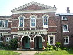 | The city's Quaker place of worship dates from 1805 but was greatly altered in the Victorian era, particularly when local architects Clayton & Black added a wing in 1876–77. The brick building is topped with a central pediment and has an adjoining cottage. | [150][151] |
| Brighton General Hospital: Arundel Building | Elm Grove 50°49′53″N 0°06′52″W / 50.8313°N 0.1144°W | %2C_Elm_Grove%2C_Brighton_(IoE_Code_480729).jpg) | Brighton's former workhouse was built at the top of Elm Grove in 1865–67 by local architect George Maynard and the London firm of J.C. and G. Lansdown. This Italianate building, the first part of the complex, became a hospital in 1935 and was given its present name in 1948. The four-storey stuccoed building has a 37-window range, several gables, clock tower with cupola and a pediment with carved dolphins. | [83][152] [153][154] |
| Brighton, Hove and Preston United Omnibus Company Electric Bus Garage and Recharging Station (former) | Kemptown 50°49′11″N 0°07′26″W / 50.8197°N 0.1239°W | .JPG) | Local architects Clayton & Black designed this modest single-storey brick-built garage in 1908 for the Brighton, Hove and Preston United Omnibus Company (predecessors of the present Brighton & Hove bus company). It was used to recharge the company's fleet of electric buses, which were introduced from mid-1909. With minimal alteration it later became a standard bus garage and then a garage and repair shop for private motor vehicles. | [155] |
| 5, 6 and 6a Brighton Place | The Lanes 50°49′18″N 0°08′25″W / 50.8216°N 0.1402°W | .JPG) | This small area of high ground was built up by the 17th century, but these late-18th-century houses (now shops) are the oldest survivors. Number 6, formerly Market House, bears the inscription God bless George IV. The sash windows are irregularly placed on the shared stuccoed façade, and the doorways are arched. | [156][157] |
| 7 and 8 Brighton Place | The Lanes 50°49′18″N 0°08′25″W / 50.8217°N 0.1402°W | .JPG) | Converted into a shop in the 20th century, these are contemporary with their neighbours. Number 8 has a first-floor bay window; this and others are sashes, and some have architraves. The roof is not continuous: number 8's is tiled, while number 7's is of slate. | [156][158] |
| Brighton Regency Synagogue (former)[C] | Kemptown 50°49′17″N 0°07′52″W / 50.8213°N 0.1310°W |  | Brighton's first permanent synagogue was designed by Jewish architect David Mocatta in 1836–38 (replacing a temporary building on the same site), but was superseded by one in Middle Street in 1875. It was in commercial use until its conversion into flats in 2005. The Classical-style stuccoed building has Tuscan pilasters and a large pediment with jews synagogue am 5598 (its founding year in the Hebrew calendar). | [159][160] [161] |
| Brighton Town Hall[A] | The Lanes 50°49′15″N 0°08′25″W / 50.8208°N 0.1402°W | | Viciously criticised when new for its severe Greek Revival design (by Thomas Cooper in 1830–32), and now not used for some of its original functions, this large T-shaped building has a double façade; both have Ionic and Doric porticos. Francis May extended it in 1898. Modern (1980s) developments surround and overshadow the building. | [162][163] [164][165] |
| Brighton Unitarian Church | North Laine 50°49′26″N 0°08′23″W / 50.8239°N 0.1396°W |  | Amon Henry Wilds built this brick and stucco chapel for the Unitarian community in 1820. The "relatively pure Grecian" exterior, with its four giant Doric columns and a tetrastyle portico, leads to a simple late-19th-century interior. There is a World War I memorial window inside. | [166][167] [168][169] |
| Brighton War Memorial | Brighton 50°49′17″N 0°08′13″W / 50.8213°N 0.1370°W | .jpg) | Local architect Sir John Simpson's World War I memorial in Valley Gardens was erected in 1922 and unveiled on 7 October that year by David Beatty, 1st Earl Beatty. The names of Brighton's 2,600 victims are engraved on bronze pylons (designed by H. Cashmore) which flank the pale stone Italianate/Classical-style columned and domed pool. This was designed to resemble a Roman water garden, and also has a fountain. The four banks of columns stand at the north end and have an inscribed screen as their centrepiece; the names of battles and warzones from the War are engraved on it. | [170][171] [172] |
| Bristol Court | Kemptown 50°49′03″N 0°07′11″W / 50.8174°N 0.1196°W | .jpg) | Businessman William Hallett designed this hotel building on Marine Parade for himself in about 1835. It became flats and The Bristol pub a century later. The name refers to Frederick Hervey, 1st Marquess of Bristol, who owned the land. It rises to four and five storeys and is divided into four bays with curved fronts and three windows to each floor. The three bays to the right have a 19th-century iron balcony at first- and second-floor level, supported on slim colonnettes. Some windows are sashes, some have cornices above and all have architraves. | [30][173] [174] |
| 9 Bristol Gardens | Kemp Town 50°49′06″N 0°06′37″W / 50.8183°N 0.1103°W | .JPG) | Built as a single house but now subdivided, this early-19th-century brick building stands behind Sussex Square. There are two flat-headed sash windows on each floor; those on the ground floor flank a pediment-topped doorcase. An entablature and cornice separate the brickwork from the slate roof. | [175] |
| 28 and 29 Bristol Road | Kemptown 50°49′09″N 0°07′35″W / 50.8191°N 0.1263°W | .jpg) | Although altered by later shopfronts and other additions, these are listed "as a very rare surviving example of an early-19th-century livery stables building". They date from the early part of that century and have stone and pebble tarred walls with some brickwork. The U-shaped building surrounds a courtyard which is reached through four archways. The windows, some of which are blank, are randomly placed on all three sides. | [176] |
| Bristol Road Methodist Church (former)[A] | Kemptown 50°49′11″N 0°07′28″W / 50.8196°N 0.1245°W | .jpg) | Thomas Lainson's Romanesque Revival church of 1873, for the Wesleyan Methodist community in the east of Brighton, was used for worship until 1989; it is now owned by Brighton College. Brown brick predominates, but polychrome brickwork is found in the dressings and other decoration. The three-stage corner tower has round-arched windows and is topped with a small octagonal spire. Next to this is an arcade-style entrance porch with a stair turret at the side. | [177][178] [179] |
| Britannia Corner | Brighton 50°49′38″N 0°08′31″W / 50.8271°N 0.1420°W | .jpg) | This was listed specifically to restrict the impact of office construction work next to it. It forms part of an 1840s-vintage bow-fronted terrace of three-storey houses at the junction of Queens Road and Upper Gloucester Road, near Brighton railway station. A modern shopfront sits below paired bow windows with original sashes. | [180][181] |
| British Engineerium: former Coal Shed | West Blatchington 50°50′39″N 0°10′31″W / 50.8441°N 0.1754°W | %2C_The_Droveway%2C_Hove_(IoE_Code_365680).jpg) | This two-storey (including one subterranean floor) slate-roofed brick building now forms part of the museum complex, but it was built as a storage facility for the pumping station in 1872. The round-arched entrance is set below a gable. | [182] |
| British Engineerium: former Cooling Pond and Leat | West Blatchington 50°50′41″N 0°10′32″W / 50.8447°N 0.1756°W | %2C_The_Droveway%2C_Hove_(IoE_Code_365679).JPG) | The former Goldstone Pumping Station in Hove, built in the 1860s, had a cooling pond and a leat (an artificial waterway) in its grounds. Although the complex is now a museum, the structures survive. The leat runs round three sides of the 1,100-square-foot (100 m2) pool, which is built of brick and terracotta. | [183] |
| British Engineerium: walls at former Pumping Station | West Blatchington 50°50′41″N 0°10′29″W / 50.8447°N 0.1748°W | %2C_The_Droveway%2C_Hove_(IoE_Code_365681).jpg) | These coursed stone walls, contemporary with the rest of the complex, enclose the British Engineerium's buildings. There is also some brickwork, and the gates are of iron. The south-facing wall has a drinking fountain inserted in an archway. | [184] |
| 14 Broad Street[A] | Brighton 50°49′15″N 0°08′05″W / 50.8208°N 0.1348°W | .jpg) | Broad Street was laid out in the 1790s as a development of lodging houses, and this three-storey house (with a dormer window above) is faced with mathematical tiles—a characteristic feature of Brighton's architecture. It also has sash windows set into segmental bays. The roof is of a gambrel design. | [95][185] |
| 1–7 Brunswick Place and 31b Western Road[A] | Brunswick Town 50°49′32″N 0°09′32″W / 50.8255°N 0.1589°W | .jpg) | Amon Henry Wilds and Charles Busby designed these four stucco-faced brick houses next to Brunswick Square at the same time (the late 1820s). They have been subdivided into flats and commercial units. Each has a three-bay façade to each of four storeys, with bow fronts, cornices, cast-iron balconies at first-floor level with acanthus decoration, and sash windows. | [186][187] |
| 2–8 Brunswick Place and 30a, 30b and 30c Western Road[A] | Brunswick Town 50°49′31″N 0°09′29″W / 50.8254°N 0.1580°W | .jpg) | Standing on the southeast side of this short street, between Western Road and Brunswick Square, these four (now converted) houses are contemporary with the four opposite and were also built by Wilds and Busby around 1828. Apart from some of the detailing around their doors, the structural features are identical to those of the opposite terrace. | [188] |
| 9–69 Brunswick Place and 107–109 Western Road[D] | Brunswick Town 50°49′33″N 0°09′32″W / 50.8258°N 0.1589°W | .jpg) | The terraces on the northern part of Brunswick Place (formerly Upper Brunswick Place) are newer than the rest of the Brunswick Town development: they were built in stages between about 1840 and 1855. They are of stuccoed brick with slate roofs, and are mostly bay-fronted. Cornices, pilasters around the doors and sash windows are common to all houses. | [186][189] |
| 10–70 Brunswick Place and 110 Western Road[F] | Brunswick Town 50°49′35″N 0°09′29″W / 50.8264°N 0.1580°W | .jpg) | Although started about 20 years after the Wilds and Busby partnership's work on the southern part of Brunswick Place, these houses share the same style. The terrace climbs a hill, as demonstrated by the constantly rising run of cast-iron balconies at first-floor level. The houses have a three-window range and either three or four storeys, and are stuccoed with some rustication. | [190][191] |
| 1–30 Brunswick Road[D] | Hove 50°49′32″N 0°09′24″W / 50.8255°N 0.1567°W | _(January_2012).JPG) | Numbers 29 and 30 were once a preparatory school at which Winston Churchill spent several happy years: he said "the impression of those years makes a pleasant picture in my mind, in strong contrast to my earlier schoolday memories". The mid-19th-century terrace of three-storey stucco-clad brick houses is bow-fronted and has a long cast-iron balustrade. | [192][193] [194] |
| 31–58 Brunswick Road[D] | Hove 50°49′34″N 0°09′22″W / 50.8261°N 0.1560°W | .jpg) | Nearly identical to the terrace on the opposite (west) side of the road, these three-storey brick and stucco houses date from the 1850s and have three storeys topped with parapets. Each has a two-window range set into a bow front. A long balustrade of iron runs along at first-floor level; below this is rusticated decoration. Some houses have been pebbledashed. | [195] |
| 64 Brunswick Street West | Brunswick Town 50°49′32″N 0°09′36″W / 50.8256°N 0.1601°W | .jpg) | Now part of the Brighton Institute of Modern Music (as BIMM House), this is Brunswick Town's original town hall. Completed at a cost of £3,000 in 1856, it became the town hall for all of Hove in 1873; but Alfred Waterhouse's Gothic Revival building on Church Road superseded it in 1882. The two-bay façade is stuccoed with stone and brickwork underneath. Some windows have cast-iron frames. | [196][197] [198] |
| 5–19 Buckingham Place[B] | West Hill 50°49′52″N 0°08′46″W / 50.8310°N 0.1462°W | .jpg) | Local artist Richard Henry Nibbs, noted for his marine art and paintings of Brighton, lived at number 7 in this Italianate-style terrace for two decades. A date of about 1845 has been attributed; the West Hill area developed around that time in response to the opening of the railway. The two-storey houses are stuccoed and have their straight-headed doorways set into recesses. Each house has a ground-floor iron balcony, with canopies except at number 7. | [199][200] |
| 30 and 32 Buckingham Place[B] | West Hill 50°49′50″N 0°08′38″W / 50.8306°N 0.1438°W | .jpg) | Built at the same time as the Italianate houses in nearby Montpelier Villas, this pair of semi-detached houses are of a similar design. Standing behind flint, brick and stucco walls which form part of the listing, they have balustraded balconies, rustication, canted windows and pilasters. | [201] |
| 47 Buckingham Place[B] | West Hill 50°49′52″N 0°08′39″W / 50.8310°N 0.1441°W | .jpg) | This is an end-of-terrace house dating, like much of Buckingham Place, from the mid-1840s. The stuccoed, partly rusticated building rises to three storeys and has sash windows set into canted bays. The doorcase has Doric pilasters. A covered balcony with anthemion-style ironwork runs across the house at first-floor level. | [199][202] |
| 49 Buckingham Place[C] | West Hill 50°49′52″N 0°08′37″W / 50.8310°N 0.1437°W | .jpg) | The former Compton Lodge is also known as St Anne's House, and now consists of flats. Before its residential conversion, it used to be a convent with a built-in observatory; it housed disabled children for a time as well. Dating from about 1820, it is older than the surrounding houses. The building has four storeys, a Doric-columned porch, and a second-floor cornice with dentil patterning. Later extensions have matched the original style. | [199][203] |
| 31 Buckingham Road[B] | West Hill 50°49′46″N 0°08′38″W / 50.8295°N 0.1440°W | .JPG) | Listed principally for its historic importance as the birthplace (on 21 August 1872) of Aubrey Beardsley, this three-storey 19th-century house stands on a corner site. It has a tiled roof and stuccoed exterior with rustication, a doorcase with entablature and pilasters, and architraved windows on one side. | [199][204] |
| 45–58 Buckingham Road[C] | West Hill 50°49′48″N 0°08′37″W / 50.8300°N 0.1435°W | .jpg) | Ventnor Villas in Hove has a nearly identical, although shorter, run of terraced villas. The Classically-inspired mid-1850s houses have paired square bays, Doric-style antae, parapets with balustrades and extensive friezework. | [205][206] |
| Burial vaults and tomb at St Nicholas' Church Graveyard | West Hill 50°49′33″N 0°08′47″W / 50.8257°N 0.1465°W | .jpg) | Opened in 1841, this was the third extension to the former parish church's graveyard. Amon Henry Wilds designed the long row of stone rubble Tudor–Gothic vaults along the north side. Each of the 14 bays is separated by a pinnacled buttress. The contemporary stone tomb of Sir Richard Phillips is included in the listing. | [207][208] [209] |
| 1 Burlington Street | Kemptown 50°49′06″N 0°07′27″W / 50.8184°N 0.1242°W | .JPG) | Amon Wilds and Charles Busby are believed to be the architects of this end-of-terrace four-storey house, whose upper storey is an attic. It dates from the mid-1820s, and like the nearby terrace at numbers 4–7 Burlington Street it has a single-window range to the right of the entrance, an entablature and a balcony with iron railings. The walls are of stucco. | [95][210] |
| 4–7 Burlington Street | Kemptown 50°49′07″N 0°07′27″W / 50.8185°N 0.1241°W | .JPG) | This terrace of four houses date from about 1825 and were probably built by Amon Wilds and Charles Busby during their productive partnership. Each house has three floors, stuccoed walls, slate roofs with dormer windows and iron balconies (formerly with verandahs). The entrances—round-arched except at number 4—are set to the left, and single bay windows stand to their right. The lowest storeys are rusticated. | [95][211] |
| 23–26 Burlington Street[A] | Kemptown 50°49′07″N 0°07′28″W / 50.8185°N 0.1244°W | .JPG) | Max Miller lived at number 25 for 15 years until his death in 1963; this is commemorated by a plaque. Number 26 has a two-window façade, while the others have one to each of their three storeys. Number 23 has been attributed to the Wilds and Busby partnership. The houses are slate-roofed and stuccoed. | [95][212] |
See also
- Buildings and architecture of Brighton and Hove
- Grade I listed buildings in Brighton and Hove
- Grade II* listed buildings in Brighton and Hove
- List of conservation areas in Brighton and Hove
References
Notes
- ↑ Dale & Gray 1976, pp. 7–8.
- ↑ "Images of England — Statistics by County (East Sussex)". Images of England. English Heritage. 2007. Archived from the original on 27 December 2012. Retrieved 27 December 2012.
- ↑ Collis 2010, p. 178.
- ↑ "Our city by the sea". The Argus. Newsquest Media Group. 18 December 2000. Archived from the original on 17 February 2013. Retrieved 17 February 2013.
- ↑ "Planning (Listed Buildings and Conservation Areas) Act 1990 (c. 9)". The UK Statute Law Database. Ministry of Justice. 24 May 1990. Archived from the original on 24 January 2013. Retrieved 11 November 2012.
- ↑ "What English Heritage Does". English Heritage. 2012. Archived from the original on 24 January 2013. Retrieved 24 January 2013.
- 1 2 3 "Listed Buildings". English Heritage. 2012. Archived from the original on 24 January 2013. Retrieved 24 January 2013.
- ↑ Historic England. "Abbey Hotel, Norfolk Terrace, Brighton (Grade II) (1380610)". National Heritage List for England. Retrieved 3 January 2013.
- ↑ Antram & Morrice 2008, p. 171.
- ↑ Wallin, James (30 March 2011). "Brighton millionaire puts hotel up for sale". The Argus. Newsquest Media Group. Archived from the original on 11 August 2016.
- ↑ Historic England. "Numbers 17 and 19 and Attached Walls and Railings 17 and 19, Abbey Road, Brighton (Grade II) (1380545)". National Heritage List for England. Retrieved 3 January 2013.
- ↑ Historic England. "Adelaide Mansions 1–4, Kingsway, BN3 2FD, Brighton (Grade II) (1205849)". National Heritage List for England. Retrieved 3 January 2013.
- ↑ Historic England. "Nos 2 and 4 Including Walls and Railings 2 and 4, Albany Villas, BN3 2RU, Brighton (Grade II) (1187540)". National Heritage List for England. Retrieved 3 January 2013.
- ↑ Historic England. "3 and 5, Albany Villas, BN3 2RS, Brighton (Grade II) (1298668)". National Heritage List for England. Retrieved 3 January 2013.
- ↑ Historic England. "Albemarle Mansions Including Piers and Walls Returned Along Road Frontage 1–3, Kingsway, BN3 2WF, Brighton (Grade II) (1187564)". National Heritage List for England. Retrieved 3 January 2013.
- ↑ Antram & Morrice 2008, p. 57.
- ↑ Historic England. "All Saints Vicarage, Eaton Road, BN3 3PJ, Hove (Grade II) (1210060)". National Heritage List for England. Retrieved 3 January 2013.
- ↑ Historic England. "Arundel Place Mews Units 2, 3, 4, 8, 8a and 9, Arundel Place, BN2 1GD, Brighton (Grade II) (1379914)". National Heritage List for England. Retrieved 3 January 2013.
- ↑ Historic England. "Arundel Place Mews Numbers 11 and 12 and Attached Walls and Piers, Arundel Place, BN2 1GD, Brighton (Grade II) (1379915)". National Heritage List for England. Retrieved 3 January 2013.
- ↑ Collis 2010, p. 67.
- ↑ Brighton Polytechnic. School of Architecture and Interior Design 1987, p. 46.
- ↑ Antram & Morrice 2008, p. 88.
- ↑ Historic England. "The Astoria Theatre, 10—14 Gloucester Place, Brighton (Grade II) (1247234)". National Heritage List for England. Retrieved 3 January 2013.
- 1 2 Antram & Morrice 2008, p. 132.
- ↑ Historic England. "Numbers 1 to 5 and Attached Railings, Atlingworth Street, BN2 1PL, Brighton (Grade II) (1379918)". National Heritage List for England. Retrieved 3 January 2013.
- ↑ Historic England. "Numbers 13 to 24 and Attached Railings, Atlingworth Street, BN2 1PL, Brighton (Grade II) (1379919)". National Heritage List for England. Retrieved 3 January 2013.
- ↑ Historic England. "Aubrey House, The Green, Brighton (Grade II) (1380998)". National Heritage List for England. Retrieved 3 January 2013.
- ↑ Historic England. "Brighton Extra Mural Cemetery: Baldwin Mausoleum, Lewes Road, Brighton (Grade II) (1381662)". National Heritage List for England. Retrieved 3 January 2013.
- ↑ Antram & Morrice 2008, p. 25.
- 1 2 Collis 2010, p. 192.
- ↑ Historic England. "Banjo Groyne on the Beach at the Bottom of Paston Place, Madeira Drive, Brighton (Grade II) (1381693)". National Heritage List for England. Retrieved 3 January 2013.
- ↑ Antram & Morrice 2008, pp. 198–199.
- ↑ Historic England. "157 Kingsway (north side) (formerly School of Nursing), Hove (Grade II) (1298639)". National Heritage List for England. Retrieved 3 January 2013.
- ↑ "Barford Court care home, 157 Kingsway, Hove, East Sussex BN3 4GR". Tomorrow’s Guides Ltd. 2010. Archived from the original on 20 February 2013. Retrieved 20 February 2013.
- ↑ Historic England. "Barn to the South West of Hillside, The Green, Brighton (Grade II) (1381009)". National Heritage List for England. Retrieved 3 January 2013.
- ↑ Historic England. "The Barn, Stanmer Park, Brighton (Grade II) (1379909)". National Heritage List for England. Retrieved 3 January 2013.
- ↑ Brighton Polytechnic. School of Architecture and Interior Design 1987, p. 126.
- ↑ Historic England. "1, Bartholomews, BN1 1HG, Brighton (Grade II) (1379920)". National Heritage List for England. Retrieved 3 January 2013.
- 1 2 3 Collis 2010, p. 17.
- ↑ Historic England. "Number 3 and Attached Railings, Bartholomews, BN1 1HG, Brighton (Grade II) (1379921)". National Heritage List for England. Retrieved 3 January 2013.
- ↑ Historic England. "4, Bartholomews, BN1 1HG, Brighton (Grade II) (1379922)". National Heritage List for England. Retrieved 3 January 2013.
- ↑ Historic England. "Number 5 and 6 and Attached Railings, Bartholomews, BN1 1HG, Brighton (Grade II) (1379923)". National Heritage List for England. Retrieved 3 January 2013.
- ↑ Historic England. "6c, Bartholomews, Brighton (Grade II) (1380463)". National Heritage List for England. Retrieved 3 January 2013.
- ↑ Historic England. "7, Bartholomews, BN1 1HG, Brighton (Grade II) (1379924)". National Heritage List for England. Retrieved 3 January 2013.
- ↑ Historic England. "The Cottage 8, Bartholomews, BN1 1HG, Brighton (Grade II) (1379973)". National Heritage List for England. Retrieved 3 January 2013.
- ↑ Collis 2010, p. 11.
- ↑ Historic England. "The Bath Arms Public House, Union Street (south side) (includes Nos. 4 and 5 Meeting House Lane), Brighton (Grade II) (1381039)". National Heritage List for England. Retrieved 3 January 2013.
- ↑ Antram & Morrice 2008, p. 79.
- ↑ Historic England. "Rottingdean Windmill at NGR 365 024, Nevill Road, Brighton (Grade II) (1380100)". National Heritage List for England. Retrieved 3 January 2013.
- ↑ Collis 2010, pp. 286–287.
- ↑ Historic England. "2, Bedford Place, BN1 2PT, Brighton (Grade II) (1379975)". National Heritage List for England. Retrieved 3 January 2013.
- 1 2 Musgrave 1981, p. 177.
- ↑ Historic England. "Numbers 4 to 7 and Attached Railings 4–7, Bedford Square, BN1 2PL, Brighton (Grade II) (1379977)". National Heritage List for England. Retrieved 3 January 2013.
- 1 2 Nairn & Pevsner 1965, p. 453.
- ↑ Historic England. "Number 8 and Attached Railings 8, Bedford Square, BN1 2PL, Brighton (Grade II) (1379978)". National Heritage List for England. Retrieved 3 January 2013.
- ↑ Historic England. "Number 9 and Attached Railings 9, Bedford Square, BN1 2PL, Brighton (Grade II) (1379979)". National Heritage List for England. Retrieved 3 January 2013.
- ↑ Historic England. "Numbers 10 to 13 and Attached Railings 10–13, Bedford Square, BN1 2PL, Brighton (Grade II) (1379980)". National Heritage List for England. Retrieved 3 January 2013.
- ↑ Historic England. "Number 14 and Attached Railings 14, Bedford Square, BN1 2PL, Brighton (Grade II) (1379981)". National Heritage List for England. Retrieved 3 January 2013.
- ↑ Historic England. "Numbers 15 and 16 and Attached Railings 15 and 16, Bedford Square, BN1 2PL, Brighton (Grade II) (1379982)". National Heritage List for England. Retrieved 3 January 2013.
- ↑ Historic England. "Numbers 21 to 25 and Attached Railings 21–25, Bedford Square, BN1 2PL, Brighton (Grade II) (1379983)". National Heritage List for England. Retrieved 3 January 2013.
- ↑ Wadsworth, Jo (22 July 2015). "First Ben Sherman factory to be converted into flat". Brighton & Hove News. Archived from the original on 23 July 2015. Retrieved 23 July 2015.
- ↑ Historic England. "26 and 27, Bedford Square, BN1 2PL, Brighton (Grade II) (1379985)". National Heritage List for England. Retrieved 3 January 2013.
- ↑ Historic England. "Numbers 28 to 31 and Attached Railings 28–31, Bedford Square, BN1 2PL, Brighton (Grade II) (1379984)". National Heritage List for England. Retrieved 3 January 2013.
- ↑ Historic England. "Numbers 32 and 33 and Attached Railings 32 and 33, Bedford Square, BN1 2PL, Brighton (Grade II) (1379986)". National Heritage List for England. Retrieved 3 January 2013.
- ↑ Historic England. "Numbers 34–39 and Attached Railings 34–39, Bedford Square, BN1 2PL, Brighton (Grade II) (1379987)". National Heritage List for England. Retrieved 3 January 2013.
- ↑ Historic England. "Numbers 17 and 18 and Attached Railings 17 and 18, Bedford Street, Brighton (Grade II) (1379990)". National Heritage List for England. Retrieved 3 January 2013.
- 1 2 3 4 5 Antram & Morrice 2008, p. 147.
- ↑ Historic England. "Numbers 1, 2 and 3 and Attached Railings 1,2 and 3, Belgrave Place, BN2 1EL, Brighton (Grade II) (1379991)". National Heritage List for England. Retrieved 3 January 2013.
- ↑ Historic England. "Numbers 4 to 7 and Attached Railings 4–7, Belgrave Place, BN2 1EL, Brighton (Grade II) (1379992)". National Heritage List for England. Retrieved 3 January 2013.
- ↑ Brighton Polytechnic. School of Architecture and Interior Design 1987, p. 67.
- ↑ Historic England. "Numbers 8, 9 and 10 and Attached Railings 8, 9 and 10, Belgrave Place, BN2 1EL, Brighton (Grade II) (1379993)". National Heritage List for England. Retrieved 3 January 2013.
- ↑ Historic England. "Numbers 11 and 12 and Attached Railings 11 and 12, Belgrave Place, BN2 1EL, Brighton (Grade II) (1379994)". National Heritage List for England. Retrieved 3 January 2013.
- ↑ Historic England. "Numbers 13 to 17 and Attached Railings 13–17, Belgrave Place, BN2 1EL, Brighton (Grade II) (1379995)". National Heritage List for England. Retrieved 3 January 2013.
- 1 2 3 4 Antram & Morrice 2008, p. 178.
- ↑ Carder 1990, §55.
- ↑ Historic England. "Number 2 and Attached Walls and Gate Piers 2, Belmont, BN1 3TF, Brighton (Grade II) (1379996)". National Heritage List for England. Retrieved 3 January 2013.
- ↑ Historic England. "3, Belmont, BN1 3TF, Brighton (Grade II) (1379997)". National Heritage List for England. Retrieved 3 January 2013.
- ↑ Historic England. "4, Belmont, BN1 3TF, Brighton (Grade II) (1379998)". National Heritage List for England. Retrieved 3 January 2013.
- ↑ Historic England. "Numbers 5 and 6 and Attached Walls 5 and 6, Belmont, BN1 3TF, Brighton (Grade II) (1379999)". National Heritage List for England. Retrieved 3 January 2013.
- ↑ Historic England. "Benfield Barn, Hangleton Lane, BN3 8AN, Brighton (Grade II) (1298634)". National Heritage List for England. Retrieved 3 January 2013.
- ↑ Salzman, L. F. (ed) (1940). "A History of the County of Sussex: Volume 7 – The Rape of Lewes. Hangleton". Victoria County History of Sussex. British History Online. pp. 277–281. Retrieved 17 June 2010.
- ↑ Collis 2010, p. 1.
- 1 2 Collis 2010, p. 151.
- ↑ Historic England. "Gates, gate piers and walls to former Bevendean Hospital, Bevendean Road (east side), Brighton (Grade II) (1380000)". National Heritage List for England. Retrieved 3 January 2013.
- ↑ Nairn & Pevsner 1965, p. 431.
- ↑ Historic England. "Bishop Hannington Memorial Church, Holmes Avenue, Brighton (Grade II) (1298638)". National Heritage List for England. Retrieved 3 January 2013.
- ↑ Stuart 2005, p. 124.
- ↑ Moens & Blyth 1953, p. 64.
- ↑ Historic England. "The Black Horse Public House 65, High Street, Brighton (Grade II) (1381620)". National Heritage List for England. Retrieved 3 January 2013.
- ↑ Antram & Morrice 2008, p. 4.
- ↑ Antram & Morrice 2008, p. 74.
- ↑ Historic England. "1, 2 and 3, Black Lion Lane, BN1 1NL, Brighton (Grade II) (1380001)". National Heritage List for England. Retrieved 3 January 2013.
- ↑ Moens & Blyth 1953, p. 68.
- ↑ Historic England. "Blacksmiths Cottage, Vicarage Lane, Brighton (Grade II) (1381074)". National Heritage List for England. Retrieved 3 January 2013.
- 1 2 3 4 5 6 7 Collis 2010, p. 105.
- 1 2 3 Antram & Morrice 2008, p. 133.
- ↑ Historic England. "Numbers 1 to 13 and Attached Railings 1–13, Bloomsbury Place, BN2 1DA, Brighton (Grade II) (1381003)". National Heritage List for England. Retrieved 3 January 2013.
- ↑ Historic England. "Numbers 15–18 and Attached Railings 15–18, Bloomsbury Place, BN2 1DA, Brighton (Grade II) (1381005)". National Heritage List for England. Retrieved 3 January 2013.
- ↑ Historic England. "Numbers 19–31 and Attached Railings 19–31, Bloomsbury Place, BN2 1DB, Brighton (Grade II) (1381006)". National Heritage List for England. Retrieved 3 January 2013.
- ↑ Historic England. "Two Bollards in front of Number 8 Wykeham Terrace, Dyke Road, Brighton (Grade II) (1380459)". National Heritage List for England. Retrieved 3 January 2013.
- ↑ Historic England. "Bollards at the North End of Kensington Gardens, Gloucester Road, Brighton (Grade II) (1380513)". National Heritage List for England. Retrieved 3 January 2013.
- ↑ Collis 2010, p. 217.
- ↑ Historic England. "Bollard at the South End of Kensington Gardens, North Road, Brighton (Grade II) (1380612)". National Heritage List for England. Retrieved 3 January 2013.
- ↑ Historic England. "Two Bollards in the Passage Next to The Regency Tavern, Regency Square, Brighton (Grade II) (1380817)". National Heritage List for England. Retrieved 3 January 2013.
- ↑ "Grade II listed bollard replaced with a stump". The Argus. Newsquest Media Group. 21 January 2013. Archived from the original on 21 January 2013. Retrieved 21 January 2013.
- 1 2 Collis 2010, p. 215.
- ↑ Historic England. "2, Bond Street, BN1 1RD, Brighton (Grade II) (1380007)". National Heritage List for England. Retrieved 3 January 2013.
- ↑ Historic England. "3, Bond Street, BN1 1RD, Brighton (Grade II) (1380008)". National Heritage List for England. Retrieved 3 January 2013.
- ↑ Historic England. "4 and 5, Bond Street, BN1 1RD, Brighton (Grade II) (1380009)". National Heritage List for England. Retrieved 3 January 2013.
- ↑ Historic England. "6, 6a, 7 and 7a, Bond Street, BN1 1RD, Brighton (Grade II) (1380010)". National Heritage List for England. Retrieved 3 January 2013.
- ↑ Historic England. "Bond Street Cottages 9, Bond Street, BN1 1RD, Brighton (Grade II) (1380011)". National Heritage List for England. Retrieved 3 January 2013.
- ↑ Historic England. "14, Bond Street, BN1 1RD, Brighton (Grade II) (1380012)". National Heritage List for England. Retrieved 3 January 2013.
- ↑ Historic England. "15 and 16, Bond Street, BN1 1RD, Brighton (Grade II) (1380013)". National Heritage List for England. Retrieved 3 January 2013.
- ↑ Collis 2010, p. 208.
- ↑ Historic England. "Booth Museum of Natural History and Attached Walls and Railings, Dyke Road, Brighton (Grade II) (1380452)". National Heritage List for England. Retrieved 3 January 2013.
- ↑ Antram & Morrice 2008, p. 110.
- ↑ Historic England. "3, Borough Street, BN1 3BG, Brighton (Grade II) (1380015)". National Heritage List for England. Retrieved 3 January 2013.
- ↑ Historic England. "8–13, Borough Street, BN1 3BG, Brighton (Grade II) (1380016)". National Heritage List for England. Retrieved 3 January 2013.
- ↑ Historic England. "16, Borough Street, BN1 3BG, Brighton (Grade II) (1380017)". National Heritage List for England. Retrieved 3 January 2013.
- ↑ Historic England. "20–24, Borough Street, BN1 3BG, Brighton (Grade II) (1380018)". National Heritage List for England. Retrieved 3 January 2013.
- 1 2 3 4 5 Collis 2010, p. 35.
- ↑ Historic England. "Boundary Stone Approximately 40 Metres North of Western Road, Boundary Passage, Brighton (Grade II) (1380005)". National Heritage List for England. Retrieved 3 January 2013.
- ↑ Historic England. "Boundary Stone at Junction of Boundary Passage and Montpelier Place, Montpelier Place, Brighton (Grade II) (1380367)". National Heritage List for England. Retrieved 3 January 2013.
- ↑ Historic England. "Boundary Stone Approximately 20 Metres from Junction with Norfolk Terrace, Temple Gardens, Brighton (Grade II) (1380984)". National Heritage List for England. Retrieved 3 January 2013.
- ↑ Historic England. "Boundary Stone on the Corner with Roedean Road, Whitehawk Road, Brighton (Grade II) (1381110)". National Heritage List for England. Retrieved 3 January 2013.
- ↑ Collis 2010, p. 172.
- ↑ Historic England. "2, Boyces Street, Brighton (Grade II) (1380021)". National Heritage List for England. Retrieved 3 January 2013.
- 1 2 Antram & Morrice 2008, p. 170.
- ↑ Historic England. "The Old Vicarage (Brighton and Hove High School For Girls), Temple Gardens, Brighton (Grade II) (1380985)". National Heritage List for England. Retrieved 3 January 2013.
- ↑ Historic England. "Brighton and Hove High School For Girls (the Temple), Denmark Terrace, Brighton (Grade II) (1389120)". National Heritage List for England. Retrieved 3 January 2013.
- ↑ Antram & Morrice 2008, pp. 127–128.
- ↑ Collis 2010, pp. 10–11.
- ↑ Historic England. "The Brighton Aquarium and Attached Walls and Piers and Railings and Lamps, Madeira Drive, Brighton (Grade II) (1381698)". National Heritage List for England. Retrieved 3 January 2013.
- ↑ Antram & Morrice 2008, p. 16.
- 1 2 Antram & Morrice 2008, p. 142.
- ↑ Historic England. "Burstow Gallery and Hall, Brighton College, Eastern Road, Brighton (Grade II) (1380477)". National Heritage List for England. Retrieved 3 January 2013.
- 1 2 Brighton Polytechnic. School of Architecture and Interior Design 1987, p. 75.
- 1 2 3 Antram & Morrice 2008, p. 141.
- 1 2 Collis 2010, p. 83.
- ↑ Historic England. "Brighton College Chapel, Eastern Road, Brighton (Grade II) (1380476)". National Heritage List for England. Retrieved 3 January 2013.
- ↑ Historic England. "Chichester House School House and Dawson Hall Brighton College, Eastern Road, Brighton (Grade II) (1380478)". National Heritage List for England. Retrieved 3 January 2013.
- ↑ Historic England. "Classroom Dining Hall and Head Masters House Brighton College, Eastern Road, Brighton (Grade II) (1380479)". National Heritage List for England. Retrieved 3 January 2013.
- ↑ Antram & Morrice 2008, pp. 91–92.
- ↑ Carder 1990, §178.
- ↑ Collis 2010, p. 71.
- ↑ Historic England. "Brighton College of Technology and Attached Walls and Gates and Railings, Richmond Terrace, Brighton (Grade II) (1380829)". National Heritage List for England. Retrieved 3 January 2013.
- ↑ Antram & Morrice 2008, p. 184.
- ↑ Carder 1990, §191.
- ↑ Historic England. "Brighton Business Centre, Ditchling Road, Brighton (Grade II) (1380440)". National Heritage List for England. Retrieved 3 January 2013.
- ↑ Antram & Morrice 2008, p. 78.
- ↑ Historic England. "Friends Meeting House and The Cottage, Ship Street, Brighton (Grade II) (1380935)". National Heritage List for England. Retrieved 3 January 2013.
- ↑ Antram & Morrice 2008, p. 180.
- ↑ Nairn & Pevsner 1965, p. 444.
- ↑ Historic England. "Brighton General Hospital, Arundel Building, Elm Grove, Brighton (Grade II) (1380497)". National Heritage List for England. Retrieved 3 January 2013.
- ↑ Historic England. "Former electric bus garage and re-charging station for the Brighton, Hove and Preston United Omnibus Co Ltd, 25 Montague Place, Brighton (Grade II) (1423929)". National Heritage List for England. Retrieved 5 June 2015.
- 1 2 Collis 2010, p. 44.
- ↑ Historic England. "5, 6 and 6a, Brighton Place, Brighton (Grade II) (1380022)". National Heritage List for England. Retrieved 3 January 2013.
- ↑ Historic England. "7 and 8, Brighton Place, Brighton (Grade II) (1380023)". National Heritage List for England. Retrieved 3 January 2013.
- ↑ Antram & Morrice 2008, p. 139.
- ↑ Collis 2010, p. 101.
- ↑ Historic England. "Numbers 38 and 39 and Attached Walls and Piers, Devonshire Place (east side), Brighton (Grade II) (1380432)". National Heritage List for England. Retrieved 3 January 2013.
- ↑ Collis 2010, pp. 341–342.
- ↑ Antram & Morrice 2008, p. 72.
- ↑ Brighton Polytechnic. School of Architecture and Interior Design 1987, p. 36.
- ↑ Historic England. "Town Hall and Attached Railings, Bartholomews, BN1 1HG, Brighton (Grade II) (1379974)". National Heritage List for England. Retrieved 3 January 2013.
- ↑ Antram & Morrice 2008, p. 11.
- ↑ Antram & Morrice 2008, p. 165.
- ↑ Nairn & Pevsner 1965, p. 437.
- ↑ Historic England. "Christ Church, New Road, Brighton (Grade II) (1380110)". National Heritage List for England. Retrieved 3 January 2013.
- ↑ Collis 2010, p. 360.
- ↑ Antram & Morrice 2008, p. 86.
- ↑ Historic England. "Brighton War Memorial, Old Steine, Brighton (Grade II) (1380675)". National Heritage List for England. Retrieved 3 January 2013.
- ↑ Antram & Morrice 2008, p. 146.
- ↑ Historic England. "Bristol Court 142 and 143, Marine Parade, Brighton (Grade II) (1381747)". National Heritage List for England. Retrieved 3 January 2013.
- ↑ Historic England. "9, Bristol Gardens, Brighton (Grade II) (1380025)". National Heritage List for England. Retrieved 3 January 2013.
- ↑ Historic England. "Stables 28 and 29, Bristol Road, Brighton (Grade II) (1380030)". National Heritage List for England. Retrieved 3 January 2013.
- ↑ Carder 1990, §23.
- ↑ Collis 2010, p. 135.
- ↑ Historic England. "Methodist Church and Attached Railings, Montague Place, Brighton (Grade II) (1380359)". National Heritage List for England. Retrieved 3 January 2013.
- ↑ Collis 2010, p. 264.
- ↑ Historic England. "Britannia Corner 52, Queens Road, Brighton (Grade II) (1380796)". National Heritage List for England. Retrieved 3 January 2013.
- ↑ Historic England. "Former Coal Shed At Goldstone Pumping Station, Woodland Drive, Brighton (Grade II) (1210170)". National Heritage List for England. Retrieved 3 January 2013.
- ↑ Historic England. "Cooling Pond and Leat At Goldstone Pumping Station, Woodland Drive, Brighton (Grade II) (1187601)". National Heritage List for England. Retrieved 3 January 2013.
- ↑ Historic England. "Walls Enclosing Goldstone Pumping Station, Woodland Drive, Brighton (Grade II) (1298616)". National Heritage List for England. Retrieved 3 January 2013.
- ↑ Historic England. "Number 14 and Attached Railings 14, Broad Street, Brighton (Grade II) (1380032)". National Heritage List for England. Retrieved 3 January 2013.
- 1 2 Middleton 1979, p. 38.
- ↑ Historic England. "Nos 1–7 and Attached Railings 1–7, Brunswick Place, BN3 1AF, Brighton (Grade II) (1187542)". National Heritage List for England. Retrieved 3 January 2013.
- ↑ Historic England. "Nos 2–8 and Attached Railings 2–8, Brunswick Place, BN3 1AF, Brighton (Grade II) (1204756)". National Heritage List for England. Retrieved 3 January 2013.
- ↑ Historic England. "Nos 9–69 (Odd) and Attached Walls and Railings 9–69, Brunswick Place (Includes Nos. 107, 108 and 109 Western Road), Brighton (Grade II) (1204771)". National Heritage List for England. Retrieved 3 January 2013.
- ↑ Antram & Morrice 2008, p. 125.
- ↑ Historic England. "Nos 10–70 (Even) and Attached Walls, Piers and Railings 10–70, Brunswick Place (Includes 110 Western Road), Brighton (Grade II) (1298669)". National Heritage List for England. Retrieved 3 January 2013.
- ↑ Middleton 1979, pp. 65–66.
- ↑ Middleton 1996, p. 94.
- ↑ Historic England. "Nos 1–30 and Attached Walls and Railings 1–30, Brunswick Road, BN3 1DB, Brighton (Grade II) (1187543)". National Heritage List for England. Retrieved 3 January 2013.
- ↑ Historic England. "Nos 31–58 and Attached Walls and Railings 31–58, Brunswick Road, BN3 1DH, Brighton (Grade II) (1281051)". National Heritage List for England. Retrieved 3 January 2013.
- ↑ Middleton 1979, pp. 78, 80.
- ↑ Historic England. "64, Brunswick Street West, BN3 1EL, Brighton (Grade II) (1187545)". National Heritage List for England. Retrieved 3 January 2013.
- ↑ "About BIMM". Brighton Institute of Modern Music. 2012. Archived from the original on 20 February 2013. Retrieved 20 February 2013.
- 1 2 3 4 Collis 2010, p. 363.
- ↑ Historic England. "Number 5–19 and Attached Walls 5–19, Buckingham Place, Brighton (Grade II) (1380033)". National Heritage List for England. Retrieved 3 January 2013.
- ↑ Historic England. "Numbers 30 and 32 and Attached Walls 30 and 32, Buckingham Place, Brighton (Grade II) (1380034)". National Heritage List for England. Retrieved 3 January 2013.
- ↑ Historic England. "Number 47 and Attached Walls 47, Buckingham Place, Brighton (Grade II) (1380035)". National Heritage List for England. Retrieved 3 January 2013.
- ↑ Historic England. "Number 49 and Attached Walls and Gate Piers 49, Buckingham Place, Brighton (Grade II) (1380036)". National Heritage List for England. Retrieved 3 January 2013.
- ↑ Historic England. "Number 31 and Attached Wall 31, Buckingham Road, Brighton (Grade II) (1380037)". National Heritage List for England. Retrieved 3 January 2013.
- ↑ Collis 2010, p. 177.
- ↑ Historic England. "Numbers 45–58 and Attached Walls and Gate Piers 45–58, Buckingham Road, Brighton (Grade II) (1380038)". National Heritage List for England. Retrieved 3 January 2013.
- ↑ Collis 2010, p. 55.
- ↑ Antram & Morrice 2008, p. 160.
- ↑ Historic England. "Burial Vaults and Tomb In Western Part of St Nicholas Graveyard, Dyke Road, Brighton (Grade II) (1380455)". National Heritage List for England. Retrieved 3 January 2013.
- ↑ Historic England. "1, Burlington Street, Brighton (Grade II) (1380039)". National Heritage List for England. Retrieved 3 January 2013.
- ↑ Historic England. "4–7, Burlington Street, Brighton (Grade II) (1380040)". National Heritage List for England. Retrieved 3 January 2013.
- ↑ Historic England. "Numbers 23 to 26 and Attached Railings 23–26, Burlington Street, Brighton (Grade II) (1380041)". National Heritage List for England. Retrieved 3 January 2013.
Bibliography
- Antram, Nicholas; Morrice, Richard (2008). Brighton and Hove. Pevsner Architectural Guides. London: Yale University Press. ISBN 978-0-300-12661-7.
- Brighton Polytechnic. School of Architecture and Interior Design (1987). A Guide to the Buildings of Brighton. Macclesfield: McMillan Martin. ISBN 1-869865-03-0.
- Carder, Timothy (1990). The Encyclopaedia of Brighton. Lewes: East Sussex County Libraries. ISBN 0-86147-315-9.
- Collis, Rose (2010). The New Encyclopaedia of Brighton. (based on the original by Tim Carder) (1st ed.). Brighton: Brighton & Hove Libraries. ISBN 978-0-9564664-0-2.
- Dale, Antony; Gray, James S. (1976). Brighton Old and New. East Ardsley: EP Publishing. ISBN 0-7158-1188-6.
- Moens, S.M.; Blyth, H.E. (April 1953) [1952]. Rottingdean — The Story of a Village (Coronation ed.). Brighton: John Beal & Son (Stationers).
- Middleton, Judy (1979). A History of Hove. Chichester: Phillimore & Co. ISBN 0-85033-325-3.
- Middleton, Judy (1996). Britain in Old Photographs: Hove. Stroud: Sutton Publishing Ltd. ISBN 0-7509-1374-6.
- Musgrave, Clifford (1981). Life in Brighton. Rochester: Rochester Press. ISBN 0-571-09285-3.
- Nairn, Ian; Pevsner, Nikolaus (1965). The Buildings of England: Sussex. Harmondsworth: Penguin Books. ISBN 0-14-071028-0.
- Stuart, Donald (2005). Old Sussex Inns. Derby: The Breedon Books Publishing Co. ISBN 1-85983-448-5.

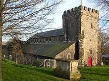
.jpg)
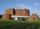

.jpg)