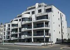
Kings House, Hove
%2C_Queen's_Gardens%2C_Hove_(NHLE_Code_1205528)_(April_2013).JPG)
Kings House is a Grade II listed building in Hove that is currently used as offices by Brighton and Hove City Council. It is situated in Grand Avenue.[1]
History
Kings House was built between 1871 and 1874 by James Knowles; originally it was built as seven mansion blocks, and was based on the style of Osborne House on the Isle of Wight.[2][3][4] It then became a hotel, called the Prince's Hotel, before being used by the Royal Navy during the Second World War.[4][5] In 1948, the building was bought by SEEBOARD to use as the company headquarters, before being bought by Brighton and Hove City Council in 1996.[5][3] In 1974, the building became a Grade II listed building.[5][6]
In July 2014, Kings House was put up for sale for £10 million, as part of a cost saving plan.[7][8] By 2015, the valuation of the property had increased to around £20 million, with staff being relocated from the building to Hove Town Hall by December 2016.[9]
References
- ↑ "Brighton council considers selling King's House". BBC News. 5 September 2013. Retrieved 10 June 2016.
- ↑ "The Streets of Brighton & Hove". Brighton History. Retrieved 10 June 2016.
- 1 2 Ridgway, Tim (23 May 2012). "Brighton and Hove City Council muse selling Kings House". Southern Daily Echo. Retrieved 10 June 2016.
- 1 2 Trimingham, Adam (8 August 2011). "Grand Avenue through the years...". The Argus. Retrieved 10 June 2016.
- 1 2 3 Nemeth, Robert (5 October 2005). "King's House". Retrieved 10 June 2016.
- ↑ "The Brighton and Hove Summary Lists of Listed Buildings" (PDF) (pdf). Brighton and Hove City Council. 28 January 2016. p. 20. Retrieved 10 June 2016.
- ↑ Ridgway, Tim (4 September 2013). "Brighton and Hove Council set to sell off Kings House". The Argus. Retrieved 10 June 2016.
- ↑ Vowles, Neil (3 July 2014). "Council offices set to go on the market". The Argus. Retrieved 10 June 2016.
- ↑ Vowles, Neil (26 October 2015). "Sale of prime seafront offices could end up netting council £24 million". Eastbourne Independent. Retrieved 10 June 2016.

.jpg)

.jpg)
Coordinates: 50°49′29″N 0°10′06″W / 50.8246°N 0.1682°W