Earl Township, Berks County, Pennsylvania
| Earl Township | |
|---|---|
| Township | |
|
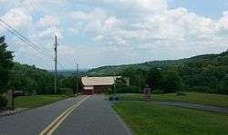
Hillside vista in Earl Township | |
 Location of Pennsylvania in the United States | |
 Earl Township Location of Earl Township in Pennsylvania | |
| Coordinates: 40°22′36″N 75°42′29″W / 40.37667°N 75.70806°WCoordinates: 40°22′36″N 75°42′29″W / 40.37667°N 75.70806°W | |
| Country | United States |
| State | Pennsylvania |
| County | Berks |
| Area | |
| • Total | 13.9 sq mi (36 km2) |
| • Land | 13.8 sq mi (36 km2) |
| • Water | 0.01 sq mi (0.03 km2) |
| Elevation | 577 ft (176 m) |
| Population (2010) | |
| • Total | 3,195 |
| • Density | 230/sq mi (89/km2) |
| Time zone | EST (UTC-5) |
| • Summer (DST) | EDT (UTC-4) |
| Area code(s) | 610 |
Earl Township is a township in Berks County, Pennsylvania, United States. The population was 3,195 at the 2010 census.
Earl Township was named for early German settler Hans Graaf, his surname Graaf meaning "earl" in English.[1]
Geography
According to the United States Census Bureau, the township has a total area of 13.9 square miles (36 km2), of which, 13.8 square miles (36 km2) of it is land and 0.1 square miles (0.26 km2) of it (0.43%) is water. It is drained by the Schuylkill River mostly via the Manatawny Creek. Its villages include Earlville (also in Amity Township,) Shanesville, Woodchoppertown, and Worman.
Adjacent townships
- Oley Township (west)
- Pike Township (north)
- Colebrookdale Township (east)
- Douglass Township (southeast)
- Amity Township (south)
Demographics
As of the census[2] of 2000, there were 3,050 people, 1,156 households, and 895 families residing in the township. The population density was 221.1 people per square mile (85.4/km²). There were 1,202 housing units at an average density of 87.1/sq mi (33.7/km²). The racial makeup of the township was 98.13% White, 0.72% African American, 0.10% Native American, 0.23% Asian, 0.03% Pacific Islander, 0.43% from other races, and 0.36% from two or more races. Hispanic or Latino of any race were 0.72% of the population.
There were 1,156 households, out of which 33.0% had children under the age of 18 living with them, 67.4% were married couples living together, 5.5% had a female householder with no husband present, and 22.5% were non-families. 18.5% of all households were made up of individuals, and 6.4% had someone living alone who was 65 years of age or older. The average household size was 2.63 and the average family size was 2.97.
| Historical population | |||
|---|---|---|---|
| Census | Pop. | %± | |
| 1980 | 2,607 | — | |
| 1990 | 3,016 | 15.7% | |
| 2000 | 3,050 | 1.1% | |
| 2010 | 3,195 | 4.8% | |
| Source: US Census Bureau | |||
In the township the population was spread out, with 22.9% under the age of 18, 7.4% from 18 to 24, 31.4% from 25 to 44, 29.0% from 45 to 64, and 9.4% who were 65 years of age or older. The median age was 39 years. For every 100 females there were 106.6 males. For every 100 females age 18 and over, there were 105.7 males.
The median income for a household in the township was $51,976, and the median income for a family was $60,363. Males had a median income of $39,861 versus $26,125 for females. The per capita income for the township was $22,527. About 1.3% of families and 3.7% of the population were below the poverty line, including 1.4% of those under age 18 and 13.1% of those age 65 or over.
References
- ↑ "Early history". Reading Eagle. Jun 9, 1896. p. 25. Retrieved 31 May 2015.
- ↑ "American FactFinder". United States Census Bureau. Retrieved 2008-01-31.