Bernville, Pennsylvania
| Bernville, Pennsylvania | |
| Borough | |
 Eagle Hotel | |
| Country | United States |
|---|---|
| State | Pennsylvania |
| County | Berks |
| School District | Tulpehocken |
| Elevation | 328 ft (100.0 m) |
| Coordinates | 40°26′01″N 76°06′40″W / 40.43361°N 76.11111°WCoordinates: 40°26′01″N 76°06′40″W / 40.43361°N 76.11111°W |
| Area | 1.1 km2 (0.4 sq mi) |
| - land | 1.1 km2 (0 sq mi) |
| - water | 0.0 km2 (0 sq mi) |
| Population | 955 (2010) |
| Density | 853.2/km2 (2,209.8/sq mi) |
| Borough | 1851 |
| Mayor | Gail Stoudt |
| Timezone | EST (UTC-5) |
| - summer (DST) | EDT (UTC-4) |
| ZIP Code | 19506 |
| Area code | 610 Exchange: 488 |
 Location of Bernville in Pennsylvania
| |
 Location of Pennsylvania in the United States
| |
Bernville is a borough in Berks County, Pennsylvania, United States. The population was 955 at the 2010 census.[1] Bernville is bordered by Penn Township to the north, east, and south and by Jefferson Township to the west.
History
Before European settlers arrived in the Tulpehocken Creek valley, the area was inhabited by the Lenape people.[2] In 1723, thirty-three Palatine families from Schoharie, New York, moved to the confluences of the Tulpehocken and Northkill Creeks.[3][4][5] By 1735, a saw and grist mill was located three and a half miles up the Tulpehocken river from Bernville.[6]
In 1737, Stephanus Umbenhauer immigrated from Bern, Switzerland, and purchased 220 acres (0.89 km2) from Thomas Penn. In 1819, Stephanus' grandson, Johann Thomas Umbenhauer, set aside 46 acres (190,000 m2) to be divided into 62 lots. On 24 August 1819, Peter Bennethum bought the first six lots. In January 1820, the town was named Bernville after Stephanus' birthplace.[7] The first house was built by Philip Filbert in 1820.[8] In 1828, the Union Canal was completed, connecting the Susquehanna and Schuylkill rivers. Union Canal guard lock #36 and Lock #36 with a lift of 5.0 feet (1.5 m) is located at the southwest corner of Bernville, near where Northkill Creek empties into Tulpehocken Creek. An historic marker on Route 183 states: "The canal, at this point, followed the north bank of the Tulpehocken. A dam, two locks, and a mule bridge made it possible for boats to cross Northkill Creek. Nearby were grist mills, a lime kiln, and a tannery."[9] Due to the proximity of the Bernville Locks and the town's location on the canal, Bernville was a primary and prospering canal port.[10][11]
In 1851, the village of Bernville, discontented with Penn Township's road maintenance and community services, incorporated as a borough.[10] The borough included the original 62 lots, most of which measured 60 by 260 feet (18 by 79 m). In 1884, the Union Canal closed.[2] With no canal or railroad access, Bernville withered. In 1950, Bernville Borough annexed property from Penn Township at both ends of Main Street.[7]
Geography
Bernville is located at 40°26′1″N 76°6′40″W / 40.43361°N 76.11111°W (40.433742, -76.111039).[12] According to the United States Census Bureau, the borough has a total area of 0.42 square miles (1.1 km2), of which 0.008 square miles (0.02 km2), or 1.52%, is water.[1] The boundary with Jefferson Township is formed primarily by Northkill Creek, but diverges from the creek north of its confluence with Little Northkill Creek.
Streets and buildings
Main Street divides Bernville roughly east-west and spans the length of the original borough. Pennsylvania Route 183, which is known as "Bernville Road", runs roughly parallel to Main Street. Route 183 was built on the route laid out for the South Mountain Railroad, which was never built.[13]
Two covered bridges, which no longer exist, crossed Northkill Creek, connecting Bernville with Jefferson Township. The Northkill Covered Bridge, 1848-~1950, crossed at 4th Street. The South Bernville Covered Bridge, 1849–1938, crossed near the South Bernville Hotel (a.k.a., Newport Hotel).[13]
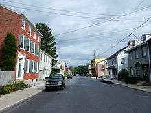
Main Street was created in 1819 and has numerous buildings dating back to the nineteenth century, including the Cyrus G. Blatt home (501-503 N. Main), the Eagle Hotel (301 N. Main) and the Joseph B. Conrad home (219 N. Main).[7] Main Street is also the location of both churches: St. Thomas's UCC, and Evangelical Lutheran Friedens Church. Both churches are located across the street from each other.
 Penn National Bank
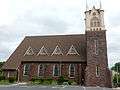 Evangelical Lutheran Friedens Church
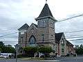 St. Thomas Church
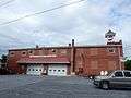 Bernville Community Fire Co. No. 1
Parks
Bernville has two parks. Umbenhauer Park, on Umbenhauer Drive, is home to a baseball field, tot-lot, and pavilion. Stanton Clay Park, on the corner of Third Street and Penn Valley Road, is home to a gazebo and a small field.
Northkill Creek feeds into Blue Marsh Lake, and the Blue Marsh slackwater is federal property. Hence a portion of Bernville is part of the Blue Marsh system. Blue Marsh Lake is a popular recreation site, offering hiking, boating, and fishing. The lake is also important for water supply, flood control, and wildlife habitat. A levee along Northkill Creek protects Bernville from Blue Marsh flooding above 300 feet (91 m) elevation.[14]
Bernville also used to be home of Blue Marsh Ski Resort, before it ceased operations in 2005.[15]
Demographics
| Historical population | |||
|---|---|---|---|
| Census | Pop. | %± | |
| 1870 | 457 | — | |
| 1880 | 405 | −11.4% | |
| 1890 | 365 | −9.9% | |
| 1900 | 344 | −5.8% | |
| 1910 | 308 | −10.5% | |
| 1920 | 302 | −1.9% | |
| 1930 | 322 | 6.6% | |
| 1940 | 339 | 5.3% | |
| 1950 | 363 | 7.1% | |
| 1960 | 884 | 143.5% | |
| 1970 | 848 | −4.1% | |
| 1980 | 798 | −5.9% | |
| 1990 | 789 | −1.1% | |
| 2000 | 865 | 9.6% | |
| 2010 | 955 | 10.4% | |
| Est. 2015 | 951 | [16] | −0.4% |
| Sources:[17][18][19] | |||
As of the census[18] of 2000, there were 865 people, 351 households, and 249 families residing in the borough. The population density was 2,121.8 people per square mile (814.6/km²). There were 372 housing units at an average density of 912.5 per square mile (350.3/km²). The racial makeup of the borough was 98.03% White, 0.58% African American, 0.81% from other races, and 0.58% from two or more races. Hispanic or Latino of any race were 1.39% of the population.
There were 351 households, out of which 31.6% had children under the age of 18 living with them, 54.7% were married couples living together, 10.8% had a female householder with no husband present, and 28.8% were non-families. 22.8% of all households were made up of individuals, and 10.3% had someone living alone who was 65 years of age or older. The average household size was 2.46 and the average family size was 2.85.
In the borough the population was spread out, with 25.2% under the age of 18, 5.8% from 18 to 24, 32.8% from 25 to 44, 20.1% from 45 to 64, and 16.1% who were 65 years of age or older. The median age was 36 years. For every 100 females there were 90.1 males. For every 100 females age 18 and over, there were 89.2 males.
The median income for a household in the borough was $41,250, and the median income for a family was $47,031. Males had a median income of $32,679 versus $25,109 for females. The per capita income for the borough was $19,038. About 7.5% of families and 8.2% of the population were below the poverty line, including 19.9% of those under age 18 and none of those age 65 or over.
Education
The Tulpehocken Area School District serves Bernville, with Penn-Bernville Elementary School in the borough.
References
- 1 2 "Geographic Identifiers: 2010 Demographic Profile Data (G001): Bernville borough, Pennsylvania". U.S. Census Bureau, American Factfinder. Retrieved March 6, 2014.
- 1 2 "Historical Summary of the Tulpehocken Creek Study Area" (PDF). Rivers Registry, Tulpehocken Creek. Harrisburg, PA: PA Dept of Conservation & National Resources. 1996-10-26. Retrieved 2008-11-17.
- ↑ "History of The Northkill Church / Evangelical Lutheran Friedens Church, Bernville, PA". Bernville, PA: Friedens Lutheran Church. Archived from the original on November 24, 2007. Retrieved 2008-11-14.
Around the year 1723 Lutheran immigrants were found along the Tulpehocken and the twin Northkill Creeks. As early as 1729 Rev. John Casper Stoever gathered them into a congregation. The services were held in homes and in barns.
- ↑ Early, J. W. (1904). "The Oldest Churches of Berks County". Transactions of the Historical Society of Berks County. I. Reading, PA: B. F. Owen & Co. p. 4. Retrieved May 7, 2013.
In the spring of 1723, thirty-three families of Germans, having been sorely oppressed and wronged, first by the Dutch and then by the English, and finally deprived of their lands and other possessions in the Schoharie, New York, came to Pennsylvania via the Susquehanna and Swatara, and settled near the Tulpehocken, about 15 miles west of the Schuylkill.
These settlers established the Zion or Reed's Lutheran church. - ↑ Boehm, J. P. (1916). W. J. Hinke, ed. Life and Letters of the Rev. John Philip Boehm. Philadelphia: Berger Bros. p. 66. Retrieved 2008-11-17.
Another congregation, which Boehm organized in 1727, was Tulpehocken. It had been settled by Palatines coming from the State of New York in 1723. Conrad Weiser describes its origin as follows: 'The people got news of the land on the Swatara and Tulpehocken in Pennsylvania. Many of them united and cut a road from Schoharie [N. Y.] to the Susquehanna River, carried their goods there, made canoes and floated them down the river to the mouth of the Swatara creek [where Middletown is situated at present], and drove their cattle over land. This happened in the spring of the year 1723. From there they came to Tulpehocken, and the was the beginning of the Tulpehocken settlement'.
- ↑ Elliott, E Z (1916). Blue Book of Schuylkill County. Pottsville, PA: J. H. Zerbey. p. 269. Retrieved 2008-11-14.
- 1 2 3 "Self-Guided Walking Tour of Main Street, Borough of Bernville, Pennsylvania". Bernville, PA. 2007.
|contribution=ignored (help) - ↑ Barr Ferree, ed. (1908). Year Book of The Pennsylvania Society. New York: The Pennsylvania Society. pp. 109–111. Retrieved 2008-11-14.
- ↑ "Search for Historical Markers". Commonwealth of Pennsylvania. Retrieved 2008-11-09.
- 1 2 "History Of Penn Township". Penn Township, Berks County, Pennsylvania. 2008. Retrieved 2008-11-09.
- ↑ Wagner, A. E.; F. W. Balthaser; D. K. Hoch (1913). The Story of Berks County. Reading, PA: Eagle Book and Job Press. pp. 213–214. Retrieved 2008-11-09.
- ↑ "US Gazetteer files: 2010, 2000, and 1990". United States Census Bureau. 2011-02-12. Retrieved 2011-04-23.
- 1 2 See interactive note #11.
- ↑ "Blue Marsh Lake, Bernville Protective Works. Design Memorandum Number 13 Schuylkill River basin. Tulpehocken Creek, Pennsylvania". U.S. Army Corps of Engineers. 1975-03-11. Retrieved 2008-11-10. Abstract: Construction of protective works for the Borough of Bernville is necessary to relieve that community of flooding hazards created by the construction of the Blue Marsh Dam and Lake project. Below elevation 300 at the proposed project site lies a relatively uninhabited low-lying area which serves as an overbank flood plain. Many commercial and private improvements, as well as a utility substation and sewage treatment facility, lie above elevation 300. Therefore, elevation 300 was fixed as the upper allowable flooding elevation from project-induces flooding. Four alternate plans--and several options under each plan--were investigated and priced to determine the most economical way to provide effective flood protection acceptable to local officials/utility owners. The alternative selected called for diverting both the upper and middle tributaries of the Schylkill River through culverts to Northkill Creek. This plan substantially reduced the size of the pond area and the anticipated use of part of this excavated material to construct the levee
- ↑ "Blue Marsh". Mid-Atlantic Lost Ski Areas. DCSki, LLC. Retrieved 2008-11-18.
- ↑ "Annual Estimates of the Resident Population for Incorporated Places: April 1, 2010 to July 1, 2015". Retrieved July 2, 2016.
- ↑ "Census of Population and Housing". U.S. Census Bureau. Archived from the original on 11 May 2015. Retrieved 11 December 2013.
- 1 2 "American FactFinder". United States Census Bureau. Archived from the original on 2013-09-11. Retrieved 2008-01-31.
- ↑ "Incorporated Places and Minor Civil Divisions Datasets: Subcounty Resident Population Estimates: April 1, 2010 to July 1, 2012". Population Estimates. U.S. Census Bureau. Archived from the original on 17 June 2013. Retrieved 11 December 2013.
External links
- Map of Bernville Borough
- Alternate map of Bernville Borough
- 2000 census map
- U.S. Army Corps of Engineers Visitor's Guide to Blue Marsh Lake
- Blue Marsh Bernville Levee
- U.S. EPA EnviroMapper
- 2000 US Census Profile of General Demographic Characteristics
- Evangelical Lutheran Friedens Church
| Wikimedia Commons has media related to Bernville, Pennsylvania. |