Doi Pha Hom Pok National Park
| Doi Pha Hom Pok National Park | |
|---|---|
| อุทยานแห่งชาติดอยผ้าห่มปก | |
|
IUCN category II (national park) | |
|
The summit of Doi Pha Hom Pok | |
 Location within Thailand | |
| Location | Chiang Mai Province, Thailand |
| Coordinates | 19°59′16″N 99°08′47″E / 19.98778°N 99.14639°ECoordinates: 19°59′16″N 99°08′47″E / 19.98778°N 99.14639°E |
| Area | 524 km2 |
| Established | 2000 |
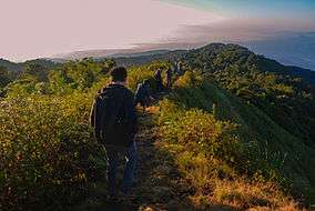
Doi Pha Hom Pok National Park (Thai: อุทยานแห่งชาติดอยผ้าห่มปก), formerly known as Mae Fang National Park,[1] is the northernmost national park in Thailand. It straddles Fang, Mae Ai, and Chai Prakan Districts of Chiang Mai Province. The park covers 524 km2 of the mountain area of the Daen Lao Range, at the border with Burma. The tallest peak is Doi Pha Hom Pok at 2,285 metres (7,497 ft), the second highest in Thailand.[2]
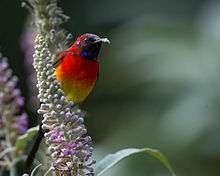
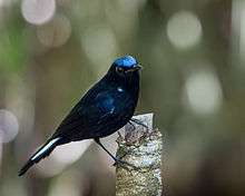
Doi Pha Hom Pok National Park is mostly covered with forest, where tree species such as Hopea odorata predominate with rare plant species such as Impatiens jurpioides and butterflies such as Meandrusa sciron. Doi Lang, located within the park, is an excellent area for birdwatching.[3]At Fang Hot Springs, park HQ, are many hot mineral springs in a 10 rai area (16,000 m2). Water temperature ranges from 90-130° C. The largest pond has hot steam rising 40-50 meters above the ground.[4]
References
- ↑ Doi Pha Hom Pok National Park
- ↑ "Doi Phahompok National Park". National Parks of Thailand. Retrieved 2016-01-12.
- ↑ Birdwatching in Thailand, Doi Lang
- ↑ "Tourist Attractions". Doi Phahompok National Park. National Parks Thailand. Retrieved 2014-11-26.
External links
| Wikimedia Commons has media related to Doi Pha Hom Pok National Park. |