Cooroibah, Queensland
| Cooroibah Noosa, Queensland | |||||||||||||
|---|---|---|---|---|---|---|---|---|---|---|---|---|---|
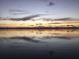 Lake Cooroibah at sunset | |||||||||||||
 Cooroibah | |||||||||||||
| Coordinates | 26°19′55″S 153°00′04″E / 26.332°S 153.001°ECoordinates: 26°19′55″S 153°00′04″E / 26.332°S 153.001°E | ||||||||||||
| Population | 1,744 (2011)[1] | ||||||||||||
| • Density | 43.28/km2 (112.08/sq mi) | ||||||||||||
| Postcode(s) | 4565 | ||||||||||||
| Area | 40.3 km2 (15.6 sq mi) | ||||||||||||
| Location | 14 km (9 mi) WNW of Noosa Heads | ||||||||||||
| LGA(s) | Shire of Noosa | ||||||||||||
| State electorate(s) | Noosa | ||||||||||||
| Federal Division(s) | Wide Bay | ||||||||||||
| |||||||||||||
Cooroibah is a suburb of Noosa, Queensland, Australia. It is within the local government area of Shire of Noosa (between 2008 and 2013 it was within Sunshine Coast Region). At the 2011 Australian Census the suburb recorded a population of 1,744.[1]
|
|
A section of the Great Sandy National Park has been established in the north of Corroibah. The Noosa River marks part of the northeast boundary and the whole of Lake Cooroibah is part of the suburb. The southern boundary continues along part of Cooroibah Creek. The largest flood event recorded at Lake Cooroibah was 2.55 metres in 1992.[2]
History
The name is Aboriginal for "place of possums".[3]
References
- 1 2 Australian Bureau of Statistics (31 October 2012). "Cooroibah (State Suburb)". 2011 Census QuickStats. Retrieved 12 October 2014.
- ↑ "Flood Warning System For The Noosa River". Bureau of Meteorology. Retrieved 11 October 2014.
- ↑ South East Queensland - Place Names 16 December 2006
External links
![]() Media related to Cooroibah, Queensland at Wikimedia Commons
Media related to Cooroibah, Queensland at Wikimedia Commons
This article is issued from Wikipedia - version of the 12/1/2016. The text is available under the Creative Commons Attribution/Share Alike but additional terms may apply for the media files.