Cooran, Queensland
| Cooran Sunshine Coast, Queensland | |||||||||||||
|---|---|---|---|---|---|---|---|---|---|---|---|---|---|
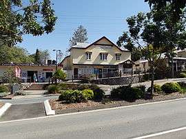 Cooran Memorial School of Arts | |||||||||||||
 Cooran Location in Queensland | |||||||||||||
| Coordinates | 26°20′07″S 152°49′25″E / 26.33528°S 152.82361°ECoordinates: 26°20′07″S 152°49′25″E / 26.33528°S 152.82361°E | ||||||||||||
| Population | 1,457 (2011 census)[1] | ||||||||||||
| Postcode(s) | 4569 | ||||||||||||
| Location |
| ||||||||||||
| LGA(s) | Shire of Noosa | ||||||||||||
| State electorate(s) | Gympie | ||||||||||||
| Federal Division(s) | Wide Bay | ||||||||||||
| |||||||||||||
Cooran is a small hinterland town and locality in the Shire of Noosa in Queensland, Australia.[2][3] Between 2008 and 2013 it was within Sunshine Coast Region. In the 2011 census, Cooran had a population of 1,457 people.[1]
Geography
Cooran is predominantly farming land with its urban centre in the north of the locality. Pinbarren Creek and Six Mile Creek flow from east to west through the northern part of the locality, while Coles Creek flows from east to west through the southern part of the locality. All the creeks flows into the Mary River.[4]
The Bruce Highway passes through the south-west corner of the locality but does not pass through the town. The major routes to the town are Traveston Road (from the north-west), Coles Creek . Road from the south-west and Greenridge-Pinbarren Road from the east.[4]
The North Coast railway line passes through the town and northern part of the locality, to the north of Traveston Road. Cooran is served by the Cooran railway station in the centre of the town.[4]
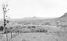
Mount Cooran is a very distinctive peak in the landscape (26°22′13″S 152°48′43″E / 26.37028°S 152.81194°E).[5]
History

The name Cooran comes from guran or kuran, meaning tall in the Kabi language.[2][3] This might refer to Mount Cooran or to the tall Moreton Bay Ash trees (Eucalyptus tessellaris).[6]
Cooran Post Office opened on 17 June 1889 (a receiving office had been open from 1888).[7]
The Cooran Provisional School opened on 21 July 1890.[8] It became Cooran State School in 1909.[9]
In the 1920s and 30s, banana growing became an important industry around the town.[10] For a period after World War II pineapple farms gained popularity in the district.[10]
Heritage listings
Cooran has a number of heritage-listed sites, including:
- 28 King Street: Alfredson's Joinery[11]
References
- 1 2 Australian Bureau of Statistics (31 October 2012). "Cooran (SSC)". 2011 Census QuickStats. Retrieved 31 August 2015.
- 1 2 "Cooran (town) (entry 8293)". Queensland Place Names. Queensland Government. Retrieved 31 August 2015.
- 1 2 "Cooran (locality) (entry 49646)". Queensland Place Names. Queensland Government. Retrieved 31 August 2015.
- 1 2 3 "Queensland Globe". State of Queensland. Retrieved 31 August 2015.
- ↑ "Mount Cooran (entry 8296)". Queensland Place Names. Queensland Government. Retrieved 31 August 2015.
- ↑ "TITLE". Queensland Places. Centre for the Government of Queensland, University of Queensland. Retrieved 31 August 2015.
- ↑ Premier Postal History. "Post Office List". Premier Postal Auctions. Retrieved 10 May 2014.
- ↑ "Opening and closing dates of Queensland Schools". Queensland Government. Retrieved 31 August 2015.
- ↑ "Agency ID5124, Cooran State School". Queensland State Archives. Retrieved 31 August 2015.
- 1 2 Environmental Protection Agency (Queensland) (2000). Heritage Trails of the Great South East. State of Queensland. p. 148. ISBN 0-7345-1008-X.
- ↑ "Alfredson's Joinery, Pre-Cut House Workshop and Sawmill (former) (entry 602690)". Queensland Heritage Register. Queensland Heritage Council. Retrieved 14 July 2013.
Further reading
- Smoothy, Judy (1990), Guran : Cooran State School : 100 years of education, Cooran State School, ISBN 978-0-7316-9365-8
External links
| Wikimedia Commons has media related to Cooran, Queensland. |
| Wikivoyage has a travel guide for Cooran. |