Kin Kin
| Kin Kin Sunshine Coast, Queensland | |||||||||||||
|---|---|---|---|---|---|---|---|---|---|---|---|---|---|
 Kin Kin | |||||||||||||
| Coordinates | 26°15′54″S 152°52′05″E / 26.265°S 152.868°ECoordinates: 26°15′54″S 152°52′05″E / 26.265°S 152.868°E | ||||||||||||
| Population | 694 (2011 census)[1] | ||||||||||||
| Postcode(s) | 4571 | ||||||||||||
| Location | 38 km (24 mi) NW of Noosa Heads | ||||||||||||
| LGA(s) | Shire of Noosa | ||||||||||||
| State electorate(s) | Gympie | ||||||||||||
| Federal Division(s) | Wide Bay | ||||||||||||
| |||||||||||||
Kin Kin is a village that lies between Pomona to the south, and Gympie to the north, in South East Queensland, Australia. The town is a hub for recreational activities related to nearby Lake Cootharaba and the Great Sandy National Park.[2] Kin Kin is in the Noosa Biosphere[3] Queensland's first UNESCO Biosphere. It is within the local government area of Shire of Noosa (between 2008 and 2013 it was within Sunshine Coast Region).
The name comes from the Aboriginal kauin kauin meaning red soil,[4][5] another source suggests it is the indigenous name for a species of small black ants that inhabit the area.[2][6] In the west of Kin Kin is Woondum National Park and Woomdum Forest Reserve. The hills and mountains in this area are covered by eucalypt forest and rainforest.[7]
History
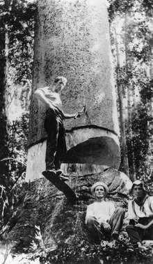

Timber-getters moved into the area in the late 1870s.[2] Until the mid-1970s Kin Kin was predominantly a smallcrop and dairy farming community, from then on land and farm usage started to change and there was a decline in production farms. Early deforestation and clearing of land led to small produce and dairy farming from the early 1900s. The butter factory was closed in 1937[2] but the sawmill still survives. Deregulation of the milk industry led to the exit of all but a handful of family dairy farms. Sadly, nine years after deregulation, the reversal of the decision in 2009 was too late for most families who had since sold. Nowadays these same farms are small hobby farms, some growing fruit trees, and many carrying horses or beef cattle. Today Kin Kin boasts health retreats, accommodation, small businesses, artists and bush foods.
The family of William D. Francis one of Queensland's pioneering botanists owned land in the area, and many native trees first identified by him are found in the area.[8]
On 14 August 1971, a tornado passed through the town killing three people.[9]
In 2007, a plan to developed a $400 million eco-tourism resort was rejected by the Government of Queensland on the grounds that the development was not part of the regional planning document.[10]
In early April 2009 the town was hit by severe flooding [11] from Kin Kin Creek a tributary of the Noosa River.
Heritage listings
Kin Kin has a number of heritage-listed sites, including:
- 1 Sister Tree Creek Road: Kin Kin Sawmill [12]
Education
Children from Kin Kin[13] attend a school in Kin Kin village up to grade 7, from 8-10 travel to Pomona, and Cooroy for 11 and 12.
See also
References
- ↑ Australian Bureau of Statistics (31 October 2012). "Kin Kin (Noosa Shire) (State Suburb)". 2011 Census QuickStats. Retrieved 2 February 2013.
- 1 2 3 4 Environmental Protection Agency (Queensland) (2000). Heritage Trails of the Great South East. State of Queensland. p. 147. ISBN 0-7345-1008-X.
- ↑ Noosa Biosphere. Retrieved 26 August 2012.
- ↑ South East Queensland - Place Names. 19 December 2006.
- ↑ Noosa Community Guide 2005 Part D. 19 December 2006.
- ↑ Noosa Attractions and Places. 7 January 2007.
- ↑ "About Woondum". Department of National Parks, Recreation, Sport and Racing. 7 January 2013. Retrieved 14 October 2014.
- ↑ Noosa Shire Historical Cultural Heritage Kin Kin July 2002. 2 January 2007.
- ↑ "Drought, Dust and Deluge: Severe Storms: Tornadoes". Bureau of Meteorology. Archived from the original on 24 March 2012. Retrieved 3 February 2013.
- ↑ "Anger over Kin Kin development rejection". ABC News. Australian Broadcasting Corporation. 18 June 2007. Retrieved 24 August 2012.
- ↑ Robert Blackmore & Sara Hicks (8 April 2009). "Flood damage and isolation in Kin Kin". ABC Sunshine Coast. Australian Broadcasting Corporation. Retrieved 24 August 2012.
- ↑ "Kin Kin Sawmill (entry 602686)". Queensland Heritage Register. Queensland Heritage Council. Retrieved 14 July 2013.
- ↑ Kin Kin State School. Department of Education and Training. Retrieved 26 August 2012.
External links
| Wikimedia Commons has media related to Kin Kin, Queensland. |