Chiloé Archipelago
| Chiloe Archipelago Archipiélago de Chiloé | |
|---|---|
|
Map of Chiloé Archipelago | |
| Country |
|
| Region | Los Lagos |
| Province | Chiloé |
| Principal city | Castro |
| Area | |
| • Total | 9,181 km2 (3,545 sq mi) |
| (1.21% of Chile) | |
| Population | |
| • Total | 154,766 |
| • Density | 17/km2 (44/sq mi) |
| • Percent | 0.91% of Chile |
| Official languages | Spanish |
| Demonym | Chilot |
The Chiloé Archipelago (Spanish: Archipiélago de Chiloé; pronounced: [tʃi.lo.ˈe]) consists of several islands lying off the coast of Chile. It is separated from mainland Chile by Chacao Channel in the north, the Sea of Chiloé in the east and Gulf of Corcovado to the southeast. All of the archipelago—except Desertores Islands, which are part of Palena Province—forms the province of Chiloé. The main island is Chiloé Island (Isla Grande de Chiloé).
Chiloé is from the Huilliche word chillwe, meaning "seagull place". Chill or chülle refers to the brown-hooded gull, and the -we suffix means 'place'. The adjective and demonym for this region is chilote in the masculine and chilota in the feminine.
Chiloé is widely known for its distinctive folklore, mythology, cuisine and unique architecture. The variety of potato which is most widely grown throughout the world is indigenous to the islands.
Geography

The province of Chiloé includes all the Chiloé Archipelago except the Grupo Desertores islands, plus the Isla Guafo. The area of Chiloé province is 9,181 square kilometres (3,545 square miles). The administrative center of the province is Castro, while the episcopal see of the Roman Catholic bishopric is Ancud. Chiloé province is part of the Los Lagos Region (Región de los Lagos), which mainly includes the Chilean lakes region on the mainland north of Chiloé. The administrative center of the region is Puerto Montt.
Chiloé Island is by far the largest island in the archipelago at 8,394 square kilometres (3,241 square miles) Chiloé Island is roughly rectangular with its long axis oriented from north to south. To the east of Chiloé Island lies the Sea of Chiloé which contains most of the other islands in the archipelago. The Sea of Chiloé is a marginal sea separating Chiloé Island from Palena Province (also called Continental Chiloé). The principal islands in the sea of Chiloé are Quinchao, Lemuy, Tranqui, and Desertores Islands. Chiloé Island is separated from the Chilean mainland by the 2 kilometres (1.2 miles) narrow Chacao Channel in the north. To the northeast and southeast of the archipelago lie the Gulf of Ancud and the Gulf of Corcovado; the former is part of the Sea of Chiloé. Some 40 kilometres (25 miles) southwest of Chiloé Island lies Guafo Island, the southernmost island of the archipelago.
Most of the good harbours are located in the north and eastern shore of Chiloé Island. The eastern shore has a series of peninsulas and inlets, notably Estero de Castro where the capital Castro is located. The western part of Chiloé Island, as well as the whole Guafo Island, is hilly and covered by forests. In Chiloé Island the hills are subdivided in two north-south ranges separated by the lakes Cucao and Huillinco. The ranges are Piuchén and Pirulil. They are the highest point in the archipelago, and do not exceed 800 metres (2,600 feet). Depressions in the western forest are occupied by numerous small lakes and bogs scattered across the landscape.
A bridge to the mainland is planned for the archipelago, despite opposition from some residents who fear pollution and habitat destruction.[1] The Chacao Channel bridge would replace the ferry that connects the village of Chacao, Ancud Comuna, on Route 5 at the northern end of Chiloé Island across the Chacao Channel with the village of Pargua, Calbuco Comuna, on the mainland.[2]
Flora and fauna
The archipelago's original vegetation is Valdivian temperate rainforest, a forest with a dense understory and a large variety of vegetal species, including mosses and ferns. The western and southern portions of the island are still largely covered by the native forest. Notable species of the forests include arrayán (Luma apiculata), roble (Nothofagus dombeyi), quila (Chusquea quila), Chilean rhubarb, and the avellano (Gevuina avellana). Fitzroya cupressoides and tepú (Tepualia stipularis) grow in the poorly drained soils of the Piuchén and Pirulil ranges.

The arrival of agriculture in pre-Hispanic times gave origin the patchy of landscape pastures and farms landscape that dominates the eastern and northern coast of Chiloé Island. Some native plants like Gevuina avellana and Fascicularia bicolor have edible seeds, and others like the Chilean rhubarb have edible stems. The most notable edible plant native to Chiloé are the potatoes of Chiloé which contrary to the Andean potatoes of Peru and Bolivia is adapted to the long-day conditions prevalent in the higher latitude region of southern Chile.[3]
The native fauna include many birds, some of which are endemic to the archipelago. Among land mammals the largest are Darwin's fox (named as such because Charles Darwin first discovered and collected a specimen on Isla San Pedro, Chiloé) and the pudú, a small deer. Marine mammals include Commerson's dolphins and South American sea lions that forms colonies at rock outcrops close to the sea. Several species of whales have been sighted around the island, notably blue whales (see also Alfaguara project) and critically endangered southern right whales.[4]
Before the end of the Llanquihue glaciation the southern parts of Chiloé Island constituted open landscapes. This changed around 12,500 years ago when climate became warmer and forests colonized the region.[5]
History
.JPG)

Chiloé Archipelago may have been populated since 12,000 – 11,800 BC according to archaeological discoveries in Monte Verde[6] located less than 50 kilometres (31 miles) to north of the main island. Chiloé's first ethnically identifiable inhabitants are believed to be the Chonos, a seafaring nomadic people. Later, about a hundred years before the arrival of the Spaniards, the Huilliche (a branch of the Mapuche) came from the mainland and settled on the eastern shore, practising agriculture and fishing.
Spanish colony (1567–1826)
The main island was first discovered by Spaniards in 1553 by Francisco de Ulloa.[7] In 1567 the island was conquered for Spain by Captain Martín Ruiz de Gamboa who was at the head of an expedition of 110 Spaniards.[7] Gamboa named the islands Nueva Galicia (New Galicia) in honor of the place of origin of Rodrigo de Quiroga who as governor had organized the expedition.[7] Gamboa established a settlement at Castro in 1567,[7] which later became the seat of a Jesuit mission, and was capital of the province until the founding of Ancud in 1768.
During the first years of the colony the spiritual labour was carried out by Mercedarians and Franciscans. The first Jesuits arrived in 1608[8] and founded in 1612 the first church in Castro. Because of the scattered population living in different islands the Jesuits established a circular mission system with numerous chapels and churches.[8] The priests of the circular mission travelled from September to May to the scattered missions using dalcas.[9] The Jesuits established a collegium in 1660 in Castro.[8] By 1767 when the Society of Jesus was suppressed there were 13 Jesuit missioners[8] and 79 chapels. From 1771 onwards the Franciscans took over the functions of the Jesuits in Chiloé.
Ancud was made capital of the Chiloé in 1767. In 1784 Chiloé Island was made a direct dependency of the colonial viceroyalty of Peru as a consequence of the Bourbon reforms, while continental Chile was a captaincy-general within the viceroyalty. The change of capital and shift to dependency corresponded to a new strategic view of the Chiloé Archipelago. While initially Chiloé was viewed by Spaniards as a colony rich enough to conquer, it later became a problematic region due to its geographical isolation from mainland Chile and the War of Arauco in the mainland. Chiloé Island was largely exempt from the turmoil that affected the Chilean mainland due to conflicts with Huilliches and Mapuches, but was notably affected in 1712 by a large Huilliche rebellion.[10]
During colonial times Chiloé served as base for a series of explorations towards the interior of Patagonia as well as to its channels. The Jesuit Nicolás Mascardi crossed the Andes trough Vuriloche Pass and set up a mission in the shores of Nahuel Huapi Lake in 1670. The Jesuits established in Chiloé bought Chonos from islands south of Chiloé to settle in the archipelago, which led to acculturation with the Spanish-Huilliche of the island.
Royalist stronghold (1812–1826)

Unlike the central region of Chile where a long war of independence resumed after a Spanish reoccupation, Chiloé never joined the Patria Vieja (Old Republic), and its population rather than conspiring to overthrow the local Spanish administration gave it wide support. From 1812 and on, men from Chiloé would be enlisted as soldiers and sent to fight in Chile, Bolivia and Peru for the royalist cause. In December 1817 the island became the last stronghold of Spanish royalists (together with Valdivia) fleeing from the Chilean mainland. A Chilean expedition led by Thomas Cochrane, 10th Earl of Dundonald disembarked 60 men under command of William Miller but failed to conquer it after the small but disastrous Battle of Agüi. Another unsuccessful conquest attempt occurred in 1824 when Jorge Beauchef, who had disembarked in Chiloé Island, was ambushed at the Battle of Mocopulli. Only on 15 January 1826 did the Royalist forces of Antonio de Quintanilla negotiate a surrender to a new military expedition led by Ramon Freire, and the island was fully incorporated into the independent Republic of Chile, although Spain did not recognize Chile until 1844.
The last Spanish military governors were:
- Mariano Osorio December 1817 – 1818
- Antonio de Quintanilla 1818 – 15 January 1826
Chilean republic (1826 onward)
Charles Darwin arrived in Chiloé on 28 June 1834 and was based there for six months, writing about his impressions of southern Chile in his diaries.[11] The archipelago had been an old royalist stronghold, and its inhabitants were known during the 19th century for complaining about not having a king. Darwin wrote of Chiloé in 1834: "The Indians ended all their complaints by saying, 'And it is only because we are poor Indians, and know nothing; but it was not so when we had a King.'"
As Chiloé had been a defensive stronghold during colonial times, the Republic of Chile used Chiloé as a starting point for its territorial expansion into the southern territories. The expedition to the Straits of Magellan, that founded Fuerte Bulnes in 1843, was assembled in Chiloé. In the 1850s Chiloé was again instrumental in the logistical support of the colonization of the Llanquihue Lake, where German settlers were given land. The last major portion of Patagonia to be incorporated into Chile, Aysén was also explored and settled from Chiloé. In the colonization process of Patagonia, Chilotes immigrants constituted a large part of the work force of the livestock enterprises that were established in Patagonia between 1890 and 1950.
During the late 19th century and the beginning of the 20th century, Chiloé lost economic and political importance to Puerto Montt on the mainland, so that by 1863 Puerto Montt was made capital of its own province and in 1927 the Chiloé Archipelago was incorporated into a new province headed by Puerto Montt.
The cathedral in Ancud was destroyed and Castro was badly damaged by the Great Chilean earthquake of 1960, the most powerful ever recorded.[12] In 1982, the provincial capital, after over 200 years, was returned to Castro.
Culture
In part because of its physical isolation from the rest of Chile, Chiloé has a very special architecture and local culture. During the colonization of Patagonia and southern Chile in the 19th century cultural elements of Chiloé spread to that zones as many chilotes migrated and settled there.
Architecture

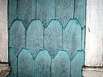

Chilotan architecture is a unique architectural style that is mainly restricted to Chiloe Island and nearby areas. In part because of its physical isolation from the rest of Chile, and access to different materials, Chiloé has a very special architecture that differs most greatly from the typical Spanish colonial architecture. The Spanish who arrived in the 16th century, and Jesuit missionaries who followed, constructed hundreds of small wooden churches in an attempt to bring Christianity to a pagan land; the result was a mixing of Catholicism and pagan beliefs. These unique buildings have been designated a UNESCO World Heritage Site.
Nearly all the houses and buildings in colonial Chiloe were built with wood, and wood shingles were extensively employed. Roof shingles of Fitzroya came to be used as money and called Real de alerce. In the late 19th century many palafitos (stilt houses) were built in cities like Castro and Chonchi.
Chilote Spanish
Chilote is a dialect of Spanish language spoken on Chiloé Archipelago. It has distinct differences from standard Chilean Spanish in accent, pronunciation, grammar and vocabulary, especially influenced by the Huilliche variant of Mapudungun.
Cuisine

The cuisine of Chiloé has its origin in pre-Hispanic traditions among native Chonos and Huilliches. Typical features of Chilote cuisine include earth oven and asado barbecues. Chilote cuisine makes extensive use of fish, shellfish and potatoes of which there are plenty of varieties growing in the archipelago's different islands. Chiloé is a center of diversity of potatoes and the origin of most of cultivated potatoes outside Andes, belonging to subspecies Solanum tuberosum tuberosum. Lamb is considered the most appreciated meat and is eaten and prepared as an asado, specially around Christmas and new year. Apple chicha is a common alcoholic beverage. Other typical alcoholic beverages are murtado and licor de oro liqueurs. Common dishes include curanto, paila marina and pulmay.
Mythology
Chiloé has a rich folklore with many mythological animals and spirits such as the Caleuche, the Trauco, the Pincoya and the Invunche. Chilota mythology is based on a mixture of indigenous religions, (the Chonos and Huilliches), that live in the Archipelago of Chiloé, and the legends and superstitions brought by the Spanish Conquistadores. In 1567 the process of conquest in Chiloé by the conquistadors brought forth the fusion of elements that would form a separate mythology. Chilota mythology flourished, isolated from other beliefs and myths in mainland Chile, due to the separation of the archipelago from the rest of the Spanish occupation in Chile, and the Mapuches occupation or destruction of all the Spanish settlements between the Bío-Bío River and the Chacao channel following the disaster of Curalaba in 1598.
According to Chilotan mythology the origin of the archipelago lies in a fierce battle between two serpents, Ten Ten-Vilu (ten, "earth", vilu, "snake") and Coi Coi-Vilu (Co, "water", vilu, "snake").
Demographics and economy
The population of the province with its ten municipalities according to the 2002 census was 154,775; of this, 44% lived in rural areas, according to the National Statistics Institute (INE). Chiloé's people are known as Chilotes.
Salmon aquaculture, tourism, agriculture and timber are the mainstays of the island economy.
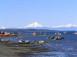
Tourism
LAN Airlines constructed a small airport in November 2012, which opened Chiloé to more tourism than it had experienced. Before the airport opened in Castro the only way to reach the islands had been by ferry. Main cultural attractions include the islands' local culture, coastline, and clear waters. Some of the islands' churches are UNESCO World Heritage sites; however, not all of them are always accessible to the public.[13]
In order to overcome the cultural and organizational barriers that keep suppliers of living cultural heritage and tour operators apart, the Chiloé diocese of Ancud established a private foundation called "Fundación con Todos" (One for All Foundation). The foundation helps repair damaged churches on the islands and assists local residents in developing tourism.[14]
In cooperation with the EOMF and the Chiloé Model Forest, a cultural and natural heritage tour was organized to Argentina and Chile, including a three-day visit to Chiloé, permitting some of the Chilote households to host a group of cultural heritage tourists for the first time. The visits were very successful and should be the first of more to come, helping establish the credibility of Chiloé's agrotourism network among other tour operators.
See also
References
- ↑ Daltroff, Lucy (25 January 2015). "The islanders who don't want a bridge to the mainland". BBC News Magazine. Archived from the original on 15 August 2015.
- ↑ Sola, Marcelo (2015). "Crossing Chacao Channel to get to Chiloé". InterPatagonia. Archived from the original on 15 August 2015.
- ↑ "Molecular description and similarity relationships among native germplasm potatoes (Solanum tuberosum ssp. tuberosum L.) using morphological data and AFLP markers". Electronic Journal of Biotechnology. Retrieved 6 December 2009.
- ↑ ObsChiloé CECPAN (2014). "ballena franca austral en Pumillahue, Chiloé.". p. YouTube. Retrieved 9 March 2015.
- ↑ Villagrán, Carolina (1988). "Late quaternary vegetation of southern Isla Grande de Chiloé, Chile". Quaternary Research. 29 (3): 294–306. Retrieved 16 November 2015.
- ↑ Dillehay, Tom D. (1997). Monte Verde, a Late Pleistocene Settlement in Chile. Washington [u.a.]: Smithsonian Institution Press. ISBN 9781560986805.
- 1 2 3 4 Hanisch, Walter (1982). La Isla de Chiloe, Capitana de Rutas Australes. Academia Superior de Ciencias Pedagógicas de Santiago. pp. 11–12.
- 1 2 3 4 Moreno, J., Rodrigo A. (2008). "Chiloé Archipelago and the Jesuits: The geographic environment of the mission in the XVII and XVIII centuries". Magallania. 39 (2): 47–55.
- ↑ Gutiérrez, Ramón (2007). "Las misiones circulares de los jesuitas en Chiloé. Apuntes para una historia singular de la evangelización". Journal of Cultural Heritage Studies. 20 (1). Retrieved 26 April 2013.
- ↑ "Rebelión huilliche de 1712" (in Spanish). Memoria Chilena. Retrieved 27 January 2013.
- ↑ Darwin, Charles (1845). The Voyage of the Beagle. London: Juhn Murray. p. 133. Retrieved 27 January 2013.
- ↑ "The Largest Earthquake in the World". US Geological Survey. Retrieved 27 January 2013.
- ↑ Ariston Anderson (25 January 2013). "Tourism comes (slowly) to Chile's best-kept secret". CNN. Retrieved 14 July 2014.
- ↑ "Fundación". Iglesias de Chiloé (in Spanish). Retrieved 14 July 2014.
| Main islands | |||||||||||||||
|---|---|---|---|---|---|---|---|---|---|---|---|---|---|---|---|
| Water bodies | |||||||||||||||
| Cities and towns | |||||||||||||||
| History | |||||||||||||||
| Culture |
| ||||||||||||||
1: These islands are not part of Chiloé Province | |||||||||||||||
Coordinates: 42°36′S 73°57′W / 42.600°S 73.950°W