Filiates
| Filiates Φιλιάτες | |
|---|---|
 | |
 Filiates | |
|
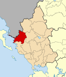
Location within the region | |
| Coordinates: 39°36′N 20°19′E / 39.600°N 20.317°ECoordinates: 39°36′N 20°19′E / 39.600°N 20.317°E | |
| Country | Greece |
| Administrative region | Epirus |
| Regional unit | Thesprotia |
| Area | |
| • Municipality | 583.5 km2 (225.3 sq mi) |
| • Municipal unit | 495.7 km2 (191.4 sq mi) |
| Population (2011)[1] | |
| • Municipality | 7,710 |
| • Municipality density | 13/km2 (34/sq mi) |
| • Municipal unit | 5,970 |
| • Municipal unit density | 12/km2 (31/sq mi) |
| Community[1] | |
| • Population | 2,639 (2011) |
| Time zone | EET (UTC+2) |
| • Summer (DST) | EEST (UTC+3) |
| Vehicle registration | ΗΝ |
Filiates (Greek: Φιλιάτες) is a town and a municipality in Thesprotia, Greece. It is located in the northernmost part of the regional unit, bordering western Ioannina regional unit and southern Albania.
Name
Filiates was known as Cestrine prior to the Ottoman period. Other ancient names for it were Cammania, Cestria, Ilion, Epirus, Troy, Epirus and Troia and Epirusis. Filiates is known as Filat in Albanian,[2] and as Filyat in Ottoman Turkish.
Municipality
The present municipality Filiates was formed at the 2011 local government reform by the merger of the following 2 former municipalities, that became municipal units (constituent communities in brackets):[3]
- Filiates (Achladea, Aetos, Agios Nikolaos, Agioi Pantes, Ampelonas, Anavryto, Charavgi, Faneromeni, Filiates, Foiniki, Gardiki, Giromeri, Gola, Kallithea, Kato Xechoro, Kefalochori, Keramitsa, Kerasochori, Kokkinia, Kokkinolithari, Kouremadi, Kryoneri, Kyparisso, Leptokarya, Lia, Lista, Malouni, Milea, Palaiochori, Palaiokklisi, Palampas, Pigadoulia, Plaisio, Platanos, Raveni, Rizo, Sideri, Trikoryfo, Tsamantas, Vavouri, Vrysella, Xechoro)
- Sagiada (Asprokklisi, Kestrini, Ragi, Sagiada, Smertos)
The municipality has an area of 583.530 km2, the municipal unit 495.727 km2.[4]
Province
The province of Filiates (Greek: Επαρχία Φιλιατών) was one of the provinces of Thesprotia. It had the same territory as the present municipality.[5] It was abolished in 2006.
Geography
Filiates is located in a largely mountainous area. The Mourgana mountains lie to the north, on the border with Albania. Filiates is located southwest of Konitsa, west of Ioannina, northeast of Igoumenitsa and southeast of Sarandë, Albania. The Greek National Road 6 (Larissa - Ioannina - Igoumenitsa) and the Egnatia Odos motorway (Alexandroupoli - Thessaloniki - Ioannina - Igoumenitsa) pass south of the municipal unit.
The municipal unit Filiates has a land area of 495.727 km²[4] and a population of 5,970 (2011 census). The population of the town Filiates, one of the biggest towns in the area, was 2,512 and the community population was 2,639. The largest other villages in the municipal unit are Keramítsa (pop. 149), Palaiochóri (142), Vrysélla (267), Leptokaryá (193), Trikóryfon (177), Aetos (134), Keramitsa (149), Kyparisso (111), Pigadoulia (116), Raveni (123) and Kokkiniá (130). The municipal unit has a total of 42 communities.[1]
Because of its high altitude (~850m) location on a west-facing slope, Filiates has one of the wettest climates in Greece.
History
Ancient history
.svg.png)
In antiquity, the area of Filiates was inhabited by the Epirot Greek tribe of the Chaonians. In antiquity the city was known as Cestrine (or Kestrine) (Greek: Κεστρίνη), separated from Thesprotia by the River Thyamis.[6] In the past, the city was also known as Cammania, Cestria, Filiates, Ilion, Epirus, Troy, Epirus and Troia, Epirus.[6] According to Pausanias (Description of Greece), Cestrine took its name from Cestrinus, the son of Helenus, having previously borne the appellation of Cammania.
Modern history

In 15th century Filiates came under Ottoman rule and became part of Sanjak of Ioannina.[7][8] During 17th and 18th century Ottoman rule a significant part of the town's population converted to Islam. In 1911 during the period of the dissolution of the Ottoman Empire, Albanians of Filiates formed çetes, armed guerilla groups fighting for autonomy from the Ottoman Empire.[9] On the other hand, the local Greek population displayed tolerance towards actions by the Albanians that didn't reveal chauvinist inclinations.[10]
During the Greek-Italian War the town of Filiates was burned by collaborationist Cham Albanian bands (October 28-November 14, 1940).[11] Filiates region was until 1944, home to a Cham Albanian community. Almost the entire population of them fled during the liberation of Greece, because a large part of the community collaborated with Nazi forces.[12] In September 1944, during the Axis withdrawal, the EDES resistance managed to quickly overcome the remaining Cham collaborator units stationed in the town. After the initial chaos and destruction that lasted for five days, the town's Cham community fled to Albania. The Cham leaders had managed to retreat together with the German troops.[13] Almost all Cham Albanian monuments of Filiates were destroyed during World War II.[14]
Population
| Year | Village | Community | Municipal unit | Municipality |
|---|---|---|---|---|
| 1981 | 2,439 | - | - | - |
| 1991 | 2,591 | - | - | - |
| 2001 | 2,246 | 2,344 | 8,288 | - |
| 2011 | 2,512 | 2,639 | 5,970 | 7,710 |
Notable people
- Anthimus VII of Constantinople (1835–1913), Ecumenical Patriarch.
- Aziz Çami, officer of the Albanian army and Balli Kombëtar commander.
- Qamil Çami, teacher and poet of era of the Albanian National Awakening.
- Ali Demi, Albanian resistance fighter (World War II).
- Musa Demi, revolutionary and important figure of the Albanian National Awakening.
- Niazi Demi, minister of trade of Albania.
- Rexhep Demi, leading member of the Albanian independence movement and signatory of the Albanian Declaration of Independence.
- Tahir Demi, high-ranking member of the Party of Labour of Albania and representative of Albania at Comecon.
- Stavroula Dimitriou, author and poet.
- Nicholas Gage, Greek American author and investigative journalist.
- Vasiliki Kontaxi, wife of Ali Pasha and member of the patriotic organization Filiki Eteria[15]
- Fanis Moulios, Greek poet and writer.[16]
- Ioannis Papacostas, Greek revolutionary and participant of Second Boer War, Balkan Wars and the autonomist struggle of Northern Epirus.
See also
References
- 1 2 3 "Απογραφή Πληθυσμού - Κατοικιών 2011. ΜΟΝΙΜΟΣ Πληθυσμός" (in Greek). Hellenic Statistical Authority.
- ↑ "The market towns of Filiates and Paramythia were albanian in speech", NGL Hammond, "Epirus: The Geography, the Ancient Remains, the History and Topography of Epirus and Adjacent Areas", page 27
- ↑ Kallikratis law Greece Ministry of Interior (Greek)
- 1 2 "Population & housing census 2001 (incl. area and average elevation)" (PDF) (in Greek). National Statistical Service of Greece.
- ↑ "Detailed census results 1991" (PDF). Archived March 3, 2016, at the Wayback Machine. (39 MB) (Greek) (French)
- 1 2 Bell, Robert (1989). Place names in classical mythology. ABC-CLIO. p. 78. ISBN 9780874365078. Retrieved November 2010. Check date values in:
|access-date=(help) - ↑ H. Karpat, Kemal (1985). Ottoman population, 1830-1914: demographic and social characteristics. p. 146. Retrieved 22 September 2011.
- ↑ Motika, Raoul (1995). Türkische Wirtschafts- und Sozialgeschichte (1071-1920). p. 297. Retrieved 22 September 2011.
Sancaks Yanya (Kazas: Yanya, Aydonat (Paramythia), Filat (Philiates), Meçova (Metsovo), Leskovik (war kurzzeitig Sancak) und Koniçe (Konitsa)
- ↑ Gawrych, George (2006). The crescent and the eagle: Ottoman rule, Islam and the Albanians, 1874-1913. I.B.Tauris. p. 188. ISBN 1-84511-287-3.
- ↑ M. V. Sakellariou.Epirus, 4000 years of Greek history and civilization. Ekdotike Athenon, 1997. ISBN 960-213-371-6. p 361: "The Greek population displayed toleration whenever the action taken did not reveal chauvinist inclinations, as in the case of establishment of Albanian "clubs" (in Konitsa, Philiates...".
- ↑ Georgia Kretsi. Verfolgungund Gedächtnis in Albanien: eine Analyse postsozialistischer Erinnerungsstrategien. Harrassowitz, 2007. ISBN 978-3-447-05544-4, p.283.
- ↑ Kretsi, Georgia (2002). "The Secret Past of the Greek-Albanian Borderlands. Cham Muslim Albanians: Perspectives on a Conflict over Historical Accountability and Current Rights". Ethnologia Balkanica (06/2002): 171–195.
- ↑ Manta, Eleftheria (2009). "The Cams of Albania and the Greek State (1923 - 1945)". Journal of Muslim Minority Affairs. 4 (9): 10. Retrieved 2 February 2016.
On the 21st of September the German forces started to withdraw... destruction prevailed in the city.
- ↑ Kiel, Machiel (1990). Ottoman architecture in Albania, 1385-1912. Research Centre for Islamic History, Art and Culture. p. 3. ISBN 978-92-9063-330-3. Retrieved 1 November 2010.
- ↑ Μουσείο Ελληνικής Ιστορίας Παύλου Βρέλλη. vrellis.gr
- ↑ "Σύγχρονοι Έλληνες συγγραφείς: Μούλιος Φάνης". ekebi (in Greek). National Book Centre of Greece. Retrieved 21 November 2015.
A Survey of the Turkish Empire p. 389, 1799 https://books.google.com/books?id=fjMOAAAAQAAJ&pg=PA389&dq=eton+speak+greek+effeminate&hl=en&sa=X&ei=eNZRU9zSBIybyAS9xIKgBA&ved=0CE8Q6AEwAw#v=onepage&q=eton%20speak%20greek%20effeminate&f=false
External links
- Official website (English) (Greek)
 |
Dhivër (Albania) | Dropull i Sipërm (Albania) and Delvinaki | Lavdani | |
| Livadhja and Markat (Albania) | |
Molossoi | ||
| ||||
| | ||||
| Sagiada and Igoumenitsa | Parapotamos | Paramythia |
| Regional unit of Arta | 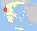 | |
|---|---|---|
| Regional unit of Ioannina | ||
| Regional unit of Preveza | ||
| Regional unit of Thesprotia | ||
| ||