Sitia
| Sitia Σητεία | ||
|---|---|---|
 | ||
| ||
 Sitia | ||
|
Location within the region  | ||
| Coordinates: 35°12′N 26°6′E / 35.200°N 26.100°ECoordinates: 35°12′N 26°6′E / 35.200°N 26.100°E | ||
| Country | Greece | |
| Administrative region | Crete | |
| Regional unit | Lasithi | |
| Government | ||
| • Mayor | Theodoros Paterakis (since 2011) | |
| Area | ||
| • Municipality | 633.2 km2 (244.5 sq mi) | |
| • Municipal unit | 277.4 km2 (107.1 sq mi) | |
| Highest elevation | 5 m (16 ft) | |
| Lowest elevation | 0 m (0 ft) | |
| Population (2011)[1] | ||
| • Municipality | 18,318 | |
| • Municipality density | 29/km2 (75/sq mi) | |
| • Municipal unit | 14,513 | |
| • Municipal unit density | 52/km2 (140/sq mi) | |
| Community[1] | ||
| • Population | 9,912 (2011) | |
| Time zone | EET (UTC+2) | |
| • Summer (DST) | EEST (UTC+3) | |
| Postal code | 72x xx | |
| Area code(s) | 28430 | |
| Vehicle registration | ΑΝ | |
| Website | www.sitia.gr | |
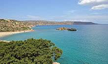
Sitia (Greek: Σητεία) is a port town and a municipality in Lasithi, Crete, Greece. The town has 9,912 inhabitants (2011); the municipality has 18,318 (2011). It lies east of Agios Nikolaos and northeast of Ierapetra. Sitia port is on the Sea of Crete, part of the Aegean Sea[2] and is one of the economic centers of the Lasithi region. European route E75, which ends in Vardø, starts in Sitia. Sitia is served by the Sitia Public Airport. Sitia has not experienced the effects of mass tourism even though there is a long beach along the road leading to Vai and several places of historical interest.
Geography
Municipality
The municipality Sitia was formed at the 2011 local government reform by the merger of the following 3 former municipalities, that became municipal units:[3]
- Itanos
- Lefki, Lasithi
- Sitia
Province
The province of Siteia (Greek: Επαρχία Σητείας) was one of the provinces of Lasithi. Its territory corresponded with that of the current municipality Siteia and the municipal unit Makry Gialos.[4] It was abolished in 2006.
Environmentally protected areas

The are a number of sites in the municipality of Sitia that are protected as National Parks, Aesthetic Forests, Wildlife Refuges etc. under national and international laws. Notable examples are:
- Dionysades Islands which carry many rare and endangered plant species and also serve as a refuge of several animal species (mostly birds and small reptiles), including the falcon, Falco eleonorae, which finds sanctuary here.
- Vai Palm Forest.
- Richtis Gorge and waterfall.[5]
Climate
| Climate data for Sitia, Greece | |||||||||||||
|---|---|---|---|---|---|---|---|---|---|---|---|---|---|
| Month | Jan | Feb | Mar | Apr | May | Jun | Jul | Aug | Sep | Oct | Nov | Dec | Year |
| Average high °F (°C) | 60 (16) |
61 (16) |
65 (18) |
72 (22) |
81 (27) |
89 (32) |
93 (34) |
93 (34) |
87 (31) |
79 (26) |
70 (21) |
63 (17) |
76.083 (24.491) |
| Average low °F (°C) | 49 (9) |
47 (8) |
49 (9) |
53 (12) |
59 (15) |
65 (18) |
68 (20) |
69 (21) |
66 (19) |
62 (17) |
57 (14) |
52 (11) |
58 (14) |
Source: <Meteoblue >Climate Sitia. Meteoblue. 2016 https://www.meteoblue.com/en/weather/forecast/modelclimate/sitia_greece_253759. Retrieved 12 September 2016. Missing or empty |title= (help) | |||||||||||||
History
The earliest settlement of the town dates back to before Minoan times; excavations in the neighbouring site of Petras have unearthed architectural remains that date back to the end of the Neolithic period 3000 BC and continue throughout the Bronze Age 3000-1050 BC. In addition, there are several Minoan settlements unearthed in the various archaeological sites in the municipality, such as in Itanos and in Mochlos.
According to Diogenes Laertius, Sitia was the home of Myson of Chen, one of the Seven Sages of Greece.
Etymology
The name Σητεία may come from the ancient Ητεία, written as Itia or Etea in English.[6]
Venetian Era
The town was later expanded and fortified by the Venetians who used it as a base of operations for the Eastern Mediterranean. During the Venetian occupation, the town was destroyed three times: by an earthquake in 1508, by a pirate attack in 1538 and finally by the Venetians themselves in 1651. Sitia was then conquered by the Ottoman Empire.
Modern Era

After the Venetians moved out of Crete, the town was abandoned for two centuries until it was resettled by farmers in 1869. The main remnant of the Venetian occupation is the Kazarma (from Italian casa di arma), the old fortress overlooking the harbour.
Infrastructure

The municipality of Sitia is served by Sitia Public Airport with several domestic destinations, the first landing was on June 7, 1984 and the airport opened officially on June 9, 1984. Construction of new building facilities that included a control tower was completed in May 1993. Runway and apron extension works were finished in May 2003. Recently (2011), the local authorities have completed negotiations with international travel agents for organizing regular charter flights starting from May 2012.[7] Currently (2011), local officials are under negotiations with the low-cost airline Ryanair[8]
In addition, Sitia is served by a port which connects Sitia and eastern Crete with several other Greek islands as well as with the port of Piraeus.[9] The town also has a marina which accommodates smaller fishing boats and yachts.
Health services
The General Hospital of Sitia was founded in 1947 as a local health center and was later (1994) relocated to a new 7500sqm (110-bed capacity) building and accordingly upgraded to serve as the main hospital for the municipality of Sitia and the surrounding area.[10]
Culture
Attractions

- Vai forest and beach, the largest natural palm forest in Europe.
- Moni Toplou, founded in the mid 15th century, is one of the most significant monasteries in Crete.
- Kazarma fortress, in the town of Sitia.
- Richtis Gorge and Waterfall at Exo Mouliana village (Map). Pictures1, Pictures2.
- Gorge of the Dead (at Kato Zakros).
- Various archeological sites with Minoan civilization settlements from the Bronze Age, such as in Itanos and Mochlos.
Notable people
- Myson - philosopher (one of the 7 legendary wise men of ancient Greece)
- Vitsentzos Kornaros - poet (composer of Erotokritos)
- Stratis Kalogeridis - musician of local folk music
- Giannis Dermitzakis - musician of local folk music
- Katerina Papoutsaki - actress
- Giannis Savvidakis - singer
- Giorgos Mazonakis - singer
- Eleni Kastani - actress
- Jenny Hiloudaki - model
- Seraina Kazamia - model
References
- 1 2 "Απογραφή Πληθυσμού - Κατοικιών 2011. ΜΟΝΙΜΟΣ Πληθυσμός" (in Greek). Hellenic Statistical Authority.
- ↑ Peter Saundry, C.Michael Hogan & Steve Baum. 2011. Sea of Crete. Encyclopedia of Earth. Eds.M.Pidwirny & C.J.Cleveland. National Council for Science and Environment. Washington DC. Archived October 13, 2012, at the Wayback Machine.
- ↑ Kallikratis law Greece Ministry of Interior (Greek)
- ↑ "Detailed census results 1991" (PDF). (39 MB) (Greek) (French)
- ↑ Richtis Gorge and Waterfall
- ↑ John Freely, Crete: Discovering the 'Great Island ISBN 1-84511-692-5, p. 154
- ↑ Charter flights 2012, (in Greek).
- ↑ Ryanair to fly to Sitia (in Greek).
- ↑ Sitia Port
- ↑ General Hospital of Sitia (in Greek).
External links
| Wikimedia Commons has media related to Sitia. |
 Sitia travel guide from Wikivoyage
- Municipality of Sitia (History)
- Vai forest
- Richtis gorge
- Gorge of the Dead
- Richtis beach and gorge
- Richtis gorge and waterfall
- 1st General Lyceum of Sitia (high school)
- Cretan Quality Agreement, local non-profit "promoting local cuisine and good health"
- Photos from Sitia
Administrative division of the Crete Region | ||
|---|---|---|
Regional unit of Chania |  | |
Regional unit of Heraklion | ||
Regional unit of Lasithi | ||
Regional unit of Rethymno | ||
| ||