Konispol
| Konispol | ||
|---|---|---|
| Municipality | ||
| ||
 Konispol | ||
| Coordinates: 39°40′N 20°11′E / 39.667°N 20.183°ECoordinates: 39°40′N 20°11′E / 39.667°N 20.183°E | ||
| Country |
| |
| County | Vlorë | |
| Government | ||
| • Mayor | Shuaip Beqiri (PJIU) | |
| Area | ||
| • Municipality | 221.88 km2 (85.67 sq mi) | |
| Elevation | 389 m (1,276 ft) | |
| Population (2011) | ||
| • Municipality | 8,245 | |
| • Municipality density | 37/km2 (96/sq mi) | |
| • Administrative Unit | 2,123 | |
| Time zone | CET (UTC+1) | |
| • Summer (DST) | CEST (UTC+2) | |
| Postal Code | 9705 | |
| Area Code | (0)891 | |
| Vehicle registration | AL | |
| Website | www.sarandaweb.net/konispoli | |

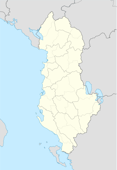
Konispol is the southernmost municipality of Albania. It sits one kilometer away from the Albanian-Greek border. It was formed at the 2015 local government reform by the merger of the former municipalities Konispol, Markat and Xarrë, that became municipal units. The seat of the municipality is the town Konispol.[1] The total population is 8,245 (2011 census), in a total area of 221.88 km2.[2] The population of the former municipality at the 2011 census was 2,123.[3] The municipal unit consists of the town Konispol and the village Çiflik.[4] The town's main interests are agriculture and viticulture. The town is inhabited by Muslim Cham Albanians. The wider municipality is inhabited by Albanians, Greeks and Aromanians.[5] and is the center of the Cham Albanian community in Albania.
Name
The name of the settlement Konispol is derived from kon'c (коньць) and polya (поля), Slavic words for end and field referring to the end of a field.[6]
History
The area was part of the ancient region of Epirus and was inhabited by Chaonian Greeks.[7]
In 1943, Konispol is noted for being the battleground of a fierce conflict between German units, Cham collaborators from Thesprotia province in Greece of Nuri Dino battalion and the communist Albanian resistance.[8]
In 1992, 7 caves were discovered just north of the town. They dated from the Upper Paleolithic age to the Iron Age.
Modern period
Konispol, due to its proximity to the Albanian-Greek borders, is part of the European Union's Greece – Albania Neighbourhood Programme for improving the standard of living of the local population by promoting sustainable local development in the cross-border area between the two countries.
Location
Konispol is:
- 191 kilometres (118 miles) from Tirana (Geographically and by road).
- 1 kilometre (0.6 miles) from the Albanian-Greek border (Geographically).
- 4 kilometres (3 miles) from Sagiada, Greece (Geographically).
Notable people
- Limos Didani, politikan
- Teme Sejko, admiral
- Osman Taka, famous folk music dancer
- Muhamet Kyçyku (Çami), Cham poet, considered a poet of the Albanian National Renaissance.
References
- ↑ Law nr. 115/2014
- ↑ Interactive map administrative territorial reform
- ↑ 2011 census results
- ↑ Greece – Albania Neighbourhood Programme Archived March 27, 2012, at the Wayback Machine.
- ↑ Kallivretakis, Leonidas (1995). "Η ελληνική κοινότητα της Αλβανίας υπό το πρίσμα της ιστορικής γεωγραφίας και δημογραφίας [The Greek Community of Albania in terms of historical geography and demography." In Nikolakopoulos, Ilias, Kouloubis Theodoros A. & Thanos M. Veremis (eds). Ο Ελληνισμός της Αλβανίας [The Greeks of Albania]. University of Athens. p. 51. "ΤΣ Τσάμηδες”; p.52. “KONISPOL Κ0ΝΙΣΠ0ΛΗ 2380 ΤΣ"
- ↑ Ylli, Xhelal (2000). Das slavische Lehngut im Albanischen. 2 [Slavic settlement in Albania. Verlag Otto Sagner. p. 127. "KONISPÓL,-I 1431 Konisboli, Vayonetya; 1856 Κονίσπολις) A. VA 37 Κονίσπολις. B. Im türk. Register als Dorf bezeichnet. VA bezieht sich mit Vorbehalt auf die Erklärung von Hilferding 287: zu *коньць поля ,Feldende‘. In diesem Fall hätte man es mit einer alten Form zu tun, die den Reflex ь> I widerspiegelt, vgl. Dibrri usw. C. EI SO 2 96 Kuhschnappel Koniecpol (pol.), Konecpol’ (russ.), HE HSK Końčnopole. [KONISPÓL,-I 1431 Konisboli, Vayonetya; 1856 Κονίσπολις) A. VA 37 Κονίσπολις. B. In Turk. In the Register called as a village. VA refers conditionally to the statement of Hilferding 287: to *коньць поля, Field's End'. In this case you would have to do with an old form that ь the reflex reflecting> I see. Dibrri etc. C. EI SO 2 96 Kuhschnappel Koniecpol (pol.), Konecpol’ (russ.), HE HSK Końčnopole.]"
- ↑ Hammond, N.G.L. (1997). "Hammond The Tribal Systems of Epirus and Neighbouring Areas down to 400 B.C.". Epirus, 4000 years of Greek history and civilization: 55.
Chaonian power thus ran from the northern end of the Gulf of Aulon (adjacent to Apollonia) to the southern end of the plain by Konispolis
- ↑ Meyer, Hermann Frank (2008). Blutiges Edelweiß: Die 1. Gebirgs-division im zweiten Weltkrieg [Bloodstained Edelweiss. The 1st Mountain-Division in WWII] (in German). Ch. Links Verlag. ISBN 978-3-86153-447-1.
External links
- Konispol Caves
- Tom J. Winnifrith, SOUTHERN ALBANIA, NORTHERN EPIRUS: Survey of a Disputed Ethnological Boundary
Municipalities in Albania are administrative divisions made up of local administrative units and their inclusive villages. | ||
| (61) |
|  |
Administrative Divisions of Vlorë County | ||
|---|---|---|
County Seat: Vlorë | ||
| Municipality of Delvinë |  | |
| Municipality of Finiq | ||
| Municipality of Himara | ||
| Municipality of Konispol | ||
| Municipality of Sarandë | ||
| Municipality of Selenicë | ||
| Municipality of Vlorë | ||
Subdivisions of Konispol Municipality | ||
|---|---|---|
Municipal Seat: Konispol | ||
| Administrative Unit of Konispol |
|  |
| Administrative Unit of Markat |
| |
| Administrative Unit of Xarrë | ||