Aubenas-les-Alpes
| Aubenas-les-Alpes | ||
|---|---|---|
|
Aubenas-les-Alpes plain | ||
| ||
 Aubenas-les-Alpes | ||
|
Location within Provence-A.-C.d'A. region  Aubenas-les-Alpes | ||
| Coordinates: 43°55′56″N 5°40′52″E / 43.9322°N 5.6811°ECoordinates: 43°55′56″N 5°40′52″E / 43.9322°N 5.6811°E | ||
| Country | France | |
| Region | Provence-Alpes-Côte d'Azur | |
| Department | Alpes-de-Haute-Provence | |
| Arrondissement | Forcalquier | |
| Canton | Reillanne | |
| Intercommunality | Haute Provence | |
| Government | ||
| • Mayor (2014–2020) | Brigitte Moya | |
| Area1 | 7.93 km2 (3.06 sq mi) | |
| Population (2010)2 | 105 | |
| • Density | 13/km2 (34/sq mi) | |
| Time zone | CET (UTC+1) | |
| • Summer (DST) | CEST (UTC+2) | |
| INSEE/Postal code | 04012 / 04110 | |
| Elevation |
480–780 m (1,570–2,560 ft) (avg. 650 m or 2,130 ft) | |
|
1 French Land Register data, which excludes lakes, ponds, glaciers > 1 km² (0.386 sq mi or 247 acres) and river estuaries. 2 Population without double counting: residents of multiple communes (e.g., students and military personnel) only counted once. | ||

Aubenas-les-Alpes is a French commune in the Alpes-de-Haute-Provence department in the Provence-Alpes-Côte d'Azur region of south-eastern France.
The inhabitants of the commune are known as Albascecois or Albascecoises.[1]
The commune has been awarded two flowers by the National Council of Towns and Villages in Bloom in the Competition of cities and villages in Bloom.[2]
Geography
Aubenas-les-Alpes lies in the Regional Natural Park of Luberon and in the Geological Reserve of Luberon some 18 km north-west of Manosque and 20 km west of La Brillanne. The village is at an altitude of 650m above sea level.[3] Access to the commune is by road D555 which branches off the D5 some 4 km north of Saint-Michel-l'Observatoire and goes west by a circuitous route to the village. There are also other country roads to access the commune. Apart from the village there is the hamlet of Le Paraire in the north. The commune is mixed farmland and forest.[4]
The Largue river forms the eastern border of the commune as it flows south to eventually join the Durance east of Manosque. Many tributaries rise in the commune and flow east to join the Largue including the Ravin d'Aiguebelle and the Riou.
Geology


The soils of the commune are formed on a substrate which is mainly limestone: this limestone is also used to roof the housing.[5] The village is however located on a hill of red marl of the Oligocene period and has yielded bones of large mammals and reptiles (crocodile and turtle). In the Aiguebelle valley (a stream that never runs dry even in the most severe droughts) fossils of plants and fish (Smerdi macrurus) have also been found. The areas of both deposits are classified as geological reserves (included in the Natural Geological Reserve of Luberon) and collecting of fossils is prohibited. Information panels are placed close by. A selection of fossils from there can be seen at the Vachères Museum,[6] at the Natural Regional Park of Luberon Maison du Parc[7] in Apt (Vaucluse), and the National Museum of Natural History in Paris (Jardin des Plantes).
Along the Largue and the Aiguebelle towards Vachères and Revest-des-Brousses, the Oligocene limestone contains lenses of brown flint which were extensively exploited from the Middle Paleolithic (Levallois-type industry) to the end of the Neolithic period. Flint was exported all over the south-east of France as far as Italy by Neolithic man.
Natural and technological hazards
None of the 200 communes of the department are in a no seismic risk zone. The Canton of Reillane, to which Aubenas-les-Alpes belongs, is zone 1b (low risk) according to the deterministic classification of 1991 based on its seismic history,[8] and zone 3 (moderate risk) according to the probabilistic classification EC8 of 2011.[9] The commune of Aubenas-les-Alpes is also exposed to three other natural hazards:[9]
- forest fire;
- landslide: the commune is almost entirely rated with an average to high hazard.[10]
The commune is not exposed to any risk of technological origin as identified by the prefecture.[11]
There is no risk prevention plan for foreseeable natural risks (PPR) for the commune[11] and also no DICRIM.[12]
Neighbouring communes and villages
 |
Revest-des-Brousses | | ||
| Vachères | |
Haute-Provence Observatory | ||
| ||||
| | ||||
| Sainte-Croix-à-Lauze | Reillanne | Saint-Michel-l'Observatoire |
Toponymy
The locality appears for the first time in texts from the 11th century in the form de Albenassio. According to Charles Rostaing, Aubenas comes from the Gallic alba with the suffixes -enne and -ate, in the general sense of a "citadel".[13] According to Ernest Nègre, the name comes from the Roman name Albinus with the suffix -àtis.[14] The Fénié propose another interpretation coming from the name Aubenas in the theme *Al-b-, having reference to the mountain.[15]
None of these explanations can explain the form of the name Aubenas in Occitan which is aùbo meaning "white poplar".
The commune changed its name to Aubenas-les-Alpes in 1934.[16]
History
The territory of the commune was inhabited in the Middle Paleolithic period but it was especially in the Neolithic that the area experienced increased human activity. The quality of the flint outcroppings in the Largue valley allows its breakdown into large blades. Due to the use of leverage,[17] these materials were produced in large numbers and many of these workshops are known to be in the commune. These blades were distributed over a wide geographical area. The density of Neolithic occupation in the Largue valley was recognized early in the 20th century. In 1906, Mr. Deydier mentioned the existence of many Neolithic flint quarries over an area of hundreds of hectares in the communes of Saint-Michel-l'Observatoire, Vachères, and Aubenas-les-Alpes.[18] The Inventory of Neolithic and protohistoric settlements lists 12 sites in the commune of Aubenas-les-Alpes.[19]
There is no indication of occupation during the metal ages.

In several parts of the commune there are ceramic Tegulae[20] and Terra sigillata which indicate occupation in Gallo-Roman times. In Antiquity the Aubenas area was part of the land of the Sogiontiques (Sogiontii),[21] whose territory extended from the Baronnies to the Durance. The Sogiontiques were federated with the Vocontii and, after the Roman conquest, they were attached with them to the Roman province of Gallia Narbonensis. In the 2nd century they were detached from Vocontii and formed a distinct Civitas with their capital at Segustero (Sisteron).[22]
While the south-east of Gaul was Burgundian land, the king of the Ostrogoths, Theodoric the Great, conquered the region between the Durance, the Rhône, and Isère in 510. The commune depended briefly on Italy until 526. In order to reconcile with the Burgundian king Godomar III, the Ostrogothic regent Amalasontha gave him the territory.[23]
Called Albenacum or Castrum de Albenis in the Middle Ages, little is known about the history of the fief of Aubenas and its fief of Aiguebelle. The present village is a relic of an urban area that covered the whole hill around the castle. The Aubenas community was under the Viguerie of Forcalquier.[24] A Benedictine priory was established at a place called Saint-Jean.[24]
The death of Queen Joanna I of Naples created a crisis of succession at the head of the County of Provence: the towns of the Union of Aix (1382-1387) supported Charles, Duke of Durazzo, against Louis I, Duke of Anjou. One of the co-lords of Aubenas, Guyon de Lincel, rallied to the Angevins in 1385 after the death of Louis I.[25]
The Largue and Aiguebelle valleys were the sites of several mills. Today a dozen mills still exist.
As with many communes in the department, Aubenas had a school well before the Jules Ferry laws: in 1863 it already had one that provided a primary education for boys in the chief town.[26] No instruction was given to girls: neither the Falloux Laws (1851), which required the opening of a girls' school in communes with more than 800 inhabitants[27] nor the first Duruy law (1867), which lowered the threshold to 500 inhabitants affected Aubenas.[28] It was only after the Ferry laws that the girls in the commune were regularly educated.
In the 20th century the cultivation of lavender was established and also a distillery.[29] Meanwhile, the culture of grapevines for the production of wine reserved for consumption was progressively phased out.[30]
Heraldry
 |
Blazon: Gules, a Roman letter A of Or from the transverse of which is interlaced an oval annulet the same posed in pale with a small latin cross the same attached below.[31] |
Administration

List of Successive Mayors[32]
| From | To | Name | Party | Position |
|---|---|---|---|---|
| 1945 | Louis Laugier[33] | |||
| 2001 | 2014 | Roland Petiet | PS | |
| 2014 | 2020 | Brigitte Moya[34] |
(Not all data is known)
Inter-communality
Aubenas-les-Alpes is part of the community of communes of Haute-Provence which includes eight communes.
Budget and taxation
| Tax | Communal part | Inter-communal part | Departmental part | Regional part |
|---|---|---|---|---|
| Household tax (TH) | 5.00% | 30.30% | 5.53% | 0.00% |
| Property tax on buildings (TFPB) | 4.30% | 8.94% | 14.49% | 2.36% |
| Property tax on undeveloped land (TFPNB) | 12.30% | 31.69% | 47.16% | 8.85% |
| Business tax (TP) | 11.73% | 6.37% | 10.80% | 3.84% |
The Business tax was replaced in 2010 by the Property contribution of businesses (CFE) on the rental value of the property and by the Value-added contribution of the business sector (CVAE) - the two forming the Territorial Economic Contribution]].
Demography
In 1315 the commune had 60 fires and in 1765 it had a population of 160.[36]
In 2010 the commune had 105 inhabitants. The evolution of the number of inhabitants is known from the population censuses conducted in the commune since 1793. From the 21st century, a census of communes with fewer than 10,000 inhabitants is held every five years, unlike larger towns that have a sample survey every year.[Note 1]
| 1793 | 1800 | 1806 | 1821 | 1831 | 1836 | 1841 | 1846 | 1851 |
|---|---|---|---|---|---|---|---|---|
| 159 | 150 | 110 | 151 | 165 | 175 | 285 | 183 | 181 |
| 1856 | 1861 | 1866 | 1872 | 1876 | 1881 | 1886 | 1891 | 1896 |
|---|---|---|---|---|---|---|---|---|
| 168 | 168 | 179 | 165 | 161 | 150 | 137 | 129 | 124 |
| 1901 | 1906 | 1911 | 1921 | 1926 | 1931 | 1936 | 1946 | 1954 |
|---|---|---|---|---|---|---|---|---|
| 114 | 97 | 108 | 75 | 74 | 63 | 62 | 56 | 54 |
| 1962 | 1968 | 1975 | 1982 | 1990 | 1999 | 2006 | 2010 | - |
|---|---|---|---|---|---|---|---|---|
| 44 | 38 | 50 | 59 | 51 | 62 | 92 | 105 | - |
Sources : Ldh/EHESS/Cassini until 1962, INSEE database from 1968 (population without double counting and municipal population from 2006)


Economy

Overview
In 2009 the labour force was 49 people including 4 unemployed[37] (11 at the end of 2011[38]). These workers are mostly employed (75%)[39] and mostly work outside the commune (68%).[39]
In 2011 the agricultural sector had two paid jobs out of 4 establishments.[40] The secondary sector has a single business.[40] Finally the 16 other businesses in the commune are identified by INSEE as in the services sector.[40]
Agriculture
At the end of 2010 the primary sector (agriculture, forestry, fisheries) had four businesses within the meaning of INSEE.[40]
From 1988 to 2000, the number of farms decreased from 8 to 5. The utilized agricultural area (SAU) followed the same movement, from 338 to 257 hectares.[41] Agricultural abandonment however seems to have stopped: the number of farms, according to Agreste Department of Agriculture survey, remained stable in the 2000s at 5: all arable farms.[42] At the same time the utilized agricultural area has increased by a third to 350 ha - more than in 1988 - which are devoted entirely to arable crops.[42]
The commune is located on the edge of production of Olive oil of Provence AOC[43] but there is no olive farm in the commune.[42]
Industry
At the end of 2010 the secondary sector (industry and construction) had one business without any employees.[40]
Service activities
At the end of 2010 the tertiary sector (trades and services) had 10 businesses with 1 employee plus six administrative establishments with 1 employee.[40]
According to Departmental Observatory of tourism, tourism is important for the commune with between 1 and 5 tourists welcomed per resident per year.[44] Accommodation in the commune consists of:
Culture and heritage

Civil heritage
The chateau dates from the end of the 16th century and was built on foundations from the 11th century. The arches on the lower floors are from the 13th century.[47] On a rectangular plan, only a single tower remains.[48] Only a little has been restored. The Vicarage is today isolated below the village although it was formerly in the village. It is a beautiful building from the 16th century with mullioned windows.
The Town Hall is located in the former presbytery and contains a small but remarkable fireplace with plasterwork from the 18th century: a rare case of chimney plasterwork in a commoner's house.[49]
During the 19th century several mills were in operation on the shores of the Largue and the Aiguebelle. Their ponds and bays can still be seen (The Paraire, the Moulin de la Combe, the Moulin Brun, the Moulin Bas, the Moulin du Plan).[50]
There is still a Dovecote in the commune in the form of a tower at Moulin.[51]
In the hamlet of Paraire there are several Renaissance houses still with their mullioned windows and lintels.[52]
Religious heritage

The Church of the Assumption of the Virgin and the Presbytery on a square shaded by hundred-year-old Linden trees are the last remains of the medieval village.[53] The church is partly Romanesque and partly rebuilt in the 17th century. Its bell tower and arches date to the 13th century.[54] Wall paintings from the 18th century have been identified in the nave and restored. Three items in the church have been registered as historical objects:
- A Reliquary-Statue: Virgin and Child (19th century)
 [55]
[55] - A Painting: The Assumption (19th century)[56]
- The Altar, altar seating, and Tabernacle (19th century)[57]
- Ornaments in the Church of the Assumption.
-

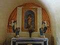
The Altar
-

The Altar with the painting of The Assumption.
-

Detail of the painting.
-
Chapel of the Virgin.
-

An old frieze depicting the pilgrimage to Saint-Jacques-de-Compostelle.
-

Modern stained glass.
Bibliography
- Raymond Collier, Haute-Provence monumental and artistic, Digne, Imprimerie Louis Jean, 1986, 559 p. (French)
- Under the direction of Édouard Baratier, Georges Duby, and Ernest Hildesheimer, Historical Atlas of Provence, County of Venaissin, Principality of Orange, County of Nice, Principality of Monaco, Librairie Armand Colin, Paris, 1969, 223 pages (French)
See also
Notes
- ↑ At the beginning of the 21st century, the methods of identification have been modified by Law No. 2002-276 of 27 February 2002, the so-called "law of local democracy" and in particular Title V "census operations" allows, after a transitional period running from 2004 to 2008, the annual publication of the legal population of the different French administrative districts. For communes with a population greater than 10,000 inhabitants, a sample survey is conducted annually, the entire territory of these communes is taken into account at the end of the period of five years. The first "legal population" after 1999 under this new law came into force on 1 January 2009 and was based on the census of 2006.
References
- ↑ Inhabitants of Alpes-de-Haute-Provence (French)
- ↑ Aubenas-les-Alpes in the Competition for Towns and Villages in Bloom Archived December 10, 2014, at the Wayback Machine. (French)
- ↑ Michel de La Torre, Alpes-de-Haute-Provence: the complete guide to 200 communes, Paris, Deslogis-Lacoste, coll. Towns and villages of France, 1989, Relié, 72 p. (non-paginated) (ISBN 2-7399-5004-7) (French)
- ↑ Google Maps
- ↑ Irène Magnaudeix et al, Haute-Provence: from Lure to Luberon. Manosque, Forcalquier Country, the mountains from Lure to Luberon, discovery guide to the paths, ADRI/Les Alpes de Lumière, 1999, ISBN 2-906924-25-3, ISBN 2-906162-47-7, p. 21. (French)
- ↑ Vachères Museum on the communal website (French)
- ↑ The Maison du Parc on the Natural Regional Park of Luberon website (French)
- ↑ Préfecture des Alpes-de-Haute-Provence, Departmental dossier on the major risks in Alpes-de-Haute-Provence (DDRM), 2008, p. 39 (French)
- 1 2 Ministry of Ecology, sustainable development, transport and lodgings, Communal Notice on the Gaspar database, online 27 May 2011, consulted on 26 June 2012 (French)
- ↑ Préfecture, DDRM, p. 37 (French)
- 1 2 Préfecture des Alpes-de-Haute-Provence, DDRM, op. cit., p. 95 (French)
- ↑ Search page Archived May 25, 2012, at the Wayback Machine., base Dicrim, consulted on 26 June 2011 (French)
- ↑ Charles Rostaing, Essay on the toponymy of Provence (since its origins until the barbarian invasions), Laffite Reprints, Marseille, 1973 (1st edition 1950), p. 49. (French)
- ↑ Ernest Nègre, General Toponymy of France: etymology of 35,000 place names, vol. 1: Pre-celtic, celtic, and roman Forms, Genève, Librairie Droz, coll. Roman and French Publications (No. 193), 1990, 1869 p. (ISBN 978-2-600-02884-4, Read online) § 2612, p 164 (French)
- ↑ Bénédicte Fénié, Jean-Jacques Fénié, Provençale Toponymy, Éditions Sud-Ouest, 2002 (reprint), ISBN 978-2-87901-442-5, p. 18 (French)
- ↑ Communal Notice on Aubenas-les-Alpes on the Cassini database, consulted on 23 July 2009. (French)
- ↑ Renault, 1998
- ↑ Marc Deydier:
Continuation of "Mallets of Malaucène", the Neolithic Largue valley, Monnoyer, 1905, 3 pages;
Contribution to the study of prehistoric mallets and axes, new varieties of polished axes, Vigot frères, 1907, 11 pages;
Prehistory around Mont-Ventoux, Monnoyer, 1908, 39 pages (French) - ↑ Neolithic and Protohistoric Settlements, Volume 3 of Documents on the prehistory of Provence, V. Cotte, A. Dragon, 1924, 162 pages (French)
- ↑ Ancient flat tiles used to cover the roof
- ↑ A Gallic people in the Southern Alps with their main town of Segustero (Sisteron).
- ↑ Brigitte Beaujard, The cities of southern Gaul from the 3rd to the 7th centuries, Gallia, 63, 2006, CNRS éditions, p. 18-19 (French)
- ↑ Audrey Becker-Piriou, From Galla Placidia to Amalasonthe, on women in roman-barbarian diplomacy in the west?, Revue historique, 2008/3, No. 647, p. 531. (French)
- 1 2 Daniel Thiery, Aubenas-les-Alpes, On the origins of churches and rural chapels in Alpes-de-Haute-Provence, published on 12 December 2010, online 15 December 2010, consulted on 25 June 2012 (French)
- ↑ Geneviève Xhayet, Supporters and opponents of Louis of Anjou during the war with the Union of Aix Archived July 23, 2015, at the Wayback Machine., Historic Provence, Fédération historique de Provence, Vol. 40, No. 162, "Author of the War of the Union of Aix", 1990, p. 412 (note 55). (French)
- ↑ Jean-Christophe Labadie (director), The School-houses, Digne-les-Bains, Departmental Archives of Alpes-de-Haute-Provence, 2013, ISBN 978-2-86-004-015-0, p. 9. (French)
- ↑ Labadie, opcit, p. 16. (French)
- ↑ Labadie, opcit, p. 18. (French)
- ↑ Irène Magnaudeix, op. cit., p. 91. (French)
- ↑ André de Réparaz, Land lost, land unchanging, land won: Vines and olives in Haute-Provence 19th-21st centuries, Méditerranée, 109, 2007, p. 56 and 59 (French)
- ↑ XVth Archaeological Journal, in Annales de Haute-Provence No. 308, 2nd trimester 1989, p. 14. (French)
- ↑ List of Mayors of France (French)
- ↑ Sébastien Thébault and Thérèse Dumont, The Liberation, Basses-Alpes 39–45, published on 31 March 2014, consulted on 3 April 2014 (French)
- ↑ Prefecture of Alpes-de-Haute-Provence, List 1: Aiglun to Braux, The communes of the department, consulted on 16 April 2014
- ↑ Local taxes in Aubenas-les-Alpes, taxes.com (French)
- ↑ Under the direction of Édouard Baratier, Georges Duby, and Ernest Hildesheimer, Historical Atlas of Provence, County of Venaissin, Principality of Orange, County of Nice, Principality of Monaco, Librairie Armand Colin, Paris, 1969, 223 pages, p. 161 (French)
- ↑ Local communal dossier: Aubenas-les-Alpes (04012), p. 5 (French)
- ↑ Insee, Dossier local, p. 8 (French)
- 1 2 Insee, Dossier local, p. 7 (French)
- 1 2 3 4 5 6 7 Insee, Dossier local, p. 16 (French)
- ↑ Agricultural businesses in 1988 and 2000, INSEE, 2012 (Page is 24.6 Mb) (French)
- 1 2 3 Ministry of Agriculture, Techno-economic orientation of farming, Agricultural census of 2010 and 2000. Read online N.B. Page is 4.4 Mb (French)
- ↑ Decree of 14 March 2007 related to Olive Oil of Provence AOC (French)
- ↑ Departmental Observatory of tourism, Atlas of Tourist Accommodation, December 2008, p. 6 (French)
- ↑ Atlas de l'hébergement..., opcit, p. 32 (French)
- ↑ Atlas de l'hébergement..., opcit, p. 38 (French)
- ↑ Raymond Collier, op. cit., p. 250. (French)
- ↑ Raymond Collier, op. cit., p. 254. (French)
- ↑ Comtesse du Chaffaut, Gypseries in Haute-Provence: pathways and stairs (16th-17th centuries), Turriers, Naturalia publications, 1995, ISBN 2-909717-22-4, p. 24. (French)
- ↑ Aubenas-les-Alpes on the Luberon Tourism website (French)
- ↑ Raymond Collier, op. cit., p. 444. (French)
- ↑ Houses at Aubenas-les-Alpes (French)
- ↑ Le Pays de Forcalquier, éditions Alpes de Lumière, bulletin n°49, 1972. (French)
- ↑ Raymond Collier, Haute-Provence monumental and artistic, Digne, Imprimerie Louis Jean, 1986, 559 p., p. 78. (French)
- ↑ Ministry of Culture, Palissy PM04003164 Reliquary-Statue: Virgin and Child (French)
- ↑ Ministry of Culture, Palissy PM04003163 Painting: The Assumption (French)
- ↑ Ministry of Culture, Palissy PM04003219 Altar, altar seating, and Tabernacle (French)
External links
| Wikimedia Commons has media related to Aubenas-les-Alpes. |
- Aubenas on the 1750 Cassini Map
- Aubenas-les-Alpes on the INSEE website (French)
- INSEE (French)