Blieux
| Blieux | ||
|---|---|---|
|
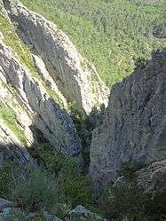
A ravine in the territory of the Blieux commune | ||
| ||
 Blieux | ||
|
Location within Provence-A.-C.d'A. region  Blieux | ||
| Coordinates: 43°52′24″N 6°22′18″E / 43.8733°N 6.3717°ECoordinates: 43°52′24″N 6°22′18″E / 43.8733°N 6.3717°E | ||
| Country | France | |
| Region | Provence-Alpes-Côte d'Azur | |
| Department | Alpes-de-Haute-Provence | |
| Arrondissement | Digne-les-Bains | |
| Canton | Barrême | |
| Intercommunality | Moyen Verdon | |
| Government | ||
| • Mayor (2008–2014) | Marcel Collomp | |
| Area1 | 56.8 km2 (21.9 sq mi) | |
| Population (2008)2 | 57 | |
| • Density | 1.0/km2 (2.6/sq mi) | |
| Time zone | CET (UTC+1) | |
| • Summer (DST) | CEST (UTC+2) | |
| INSEE/Postal code | 04030 / 04330 | |
| Elevation |
831–1,921 m (2,726–6,302 ft) (avg. 950 m or 3,120 ft) | |
|
1 French Land Register data, which excludes lakes, ponds, glaciers > 1 km² (0.386 sq mi or 247 acres) and river estuaries. 2 Population without double counting: residents of multiple communes (e.g., students and military personnel) only counted once. | ||

Blieux is a commune in the Alpes-de-Haute-Provence department in southeastern France.
History
The commune of Blieux first appeared on maps in 1100.[1]
Much later, during the French Revolution, records show that the residents of Blieux had created a political club (patriotic society), which was very common at the time. (See Jacobin Club).[2]
Name of the commune
According to Ernest Nègre, the first recorded name for the commune, Bleus, was derived from the Occitan word bleusse, meaning 'dry'. This was likely a reference to the local soil.[3] By contrast, Charles Rostaing argues that the name derives from the pre-Indo-European root word, *BL, meaning 'mountain in the form of a spur'.[4]
La Melle, the name of a nearby hamlet, comes from the Celtic word, mello, meaning an elevated location.[5]
Economy
Historically, Blieux was a pastoral community, with a yearly alpine grazing cyle known as transhumance. As with much of Provence, tourism the primary source of economic activity today.
Geography
The village is located at an altitude of 950m,[1] in the vally formed by a tributary of the river Asse, known as the 'Asse de Blieux'.
Hamlets
- le Bas-Chadoul
- la Melle
- la Tuilière
- Thon
- La Castelle
Summits and passes
- Mont Chiran (1905 m)
- le Grand Mourre (1898 m)
- Crête de Montmuye (Montmuye ridge) (Highest point: 1621 m)
- Le Mourre de Chanier ( 1930 m)
Population
| Historical population | ||
|---|---|---|
| Year | Pop. | ±% |
| 1765 | 823 | — |
| 1793 | 913 | +10.9% |
| 1800 | 801 | −12.3% |
| 1806 | 818 | +2.1% |
| 1821 | 810 | −1.0% |
| 1831 | 907 | +12.0% |
| 1836 | 969 | +6.8% |
| 1841 | 876 | −9.6% |
| 1846 | 802 | −8.4% |
| 1851 | 780 | −2.7% |
| 1856 | 735 | −5.8% |
| 1861 | 736 | +0.1% |
| 1866 | 650 | −11.7% |
| 1872 | 598 | −8.0% |
| 1876 | 573 | −4.2% |
| 1881 | 560 | −2.3% |
| 1886 | 537 | −4.1% |
| 1891 | 508 | −5.4% |
| 1896 | 449 | −11.6% |
| 1901 | 442 | −1.6% |
| 1906 | 403 | −8.8% |
| 1911 | 374 | −7.2% |
| 1921 | 241 | −35.6% |
| 1926 | 200 | −17.0% |
| 1931 | 181 | −9.5% |
| 1936 | 160 | −11.6% |
| 1946 | 110 | −31.2% |
| 1954 | 100 | −9.1% |
| 1962 | 73 | −27.0% |
| 1968 | 59 | −19.2% |
| 1975 | 54 | −8.5% |
| 1982 | 59 | +9.3% |
| 1990 | 57 | −3.4% |
| 1999 | 59 | +3.5% |
| 2008 | 57 | −3.4% |
With the exception of those that have been totally abandoned, Blieux is one of the communities in the Alpes-de-Haute-Provence department that has experienced the greatest population decline from the mid-19th to the mid-20th centuries.
Inhabitants are known as Blieuxois.
See also
References
- 1 2 de La Torre, Michel (1989). Deslogis-Lacoste, ed. Alpes-de-Haute-Provence : le guide complet des 200 communes (in French). Paris. p. 72. ISBN 2-7399-5004-7.
- ↑ Patrice Alphand, « Les Sociétés populaires», La Révolution dans les Basses-Alpes, Annales de Haute-Provence, bulletin de la société scientifique et littéraire des Alpes-de-Haute-Provence, no. 307, 1989, pp. 296-298
- ↑ Ernest Nègre, Toponymie générale de la France : étymologie de 35 000 noms de lieux, Genève : Librairie Droz, 1990. Volume II : Formations dialectales. Notice 23793, p 1281
- ↑ Charles Rostaing, Essai sur la toponymie de la Provence (depuis les origines jusqu’aux invasions barbares), Laffite Reprints, Marseille, 1973, p. 85
- ↑ Rostaing, p. 206
| Wikimedia Commons has media related to Blieux. |