Zubtsov
| Zubtsov (English) Зубцов (Russian) | |
|---|---|
| - Town[1] - | |
 Zubtsov in winter | |
.svg.png) Location of Tver Oblast in Russia | |
 Zubtsov | |
|
| |
.png) |
|
|
| |
| Administrative status (as of December 2012) | |
| Country | Russia |
| Federal subject | Tver Oblast[1] |
| Administrative district | Zubtsovsky District[2] |
| Urban settlement | Zubtsov[2] |
| Administrative center of | Zubtsovsky District,[3] Zubtsov Urban Settlement[2] |
| Municipal status (as of March 2011) | |
| Municipal district | Zubtsovsky Municipal District[4] |
| Urban settlement | Zubtsov Urban Settlement[4] |
| Administrative center of | Zubtsovsky Municipal District,[4] Zubtsov Urban Settlement[4] |
| Statistics | |
| Population (2010 Census) | 6,927 inhabitants[5] |
| Time zone | MSK (UTC+03:00)[6] |
| First mentioned | 1216[7] |
| Postal code(s)[8] | 172332, 172333 |
|
| |
| Zubtsov on Wikimedia Commons | |
Zubtsov (Russian: Зубцо́в) is a town and the administrative center of Zubtsovsky District in Tver Oblast, Russia, located at the confluence of the Volga and Vazuza Rivers, 153 kilometers (95 mi) south of Tver, the administrative center of the oblast. Population: 6,927 (2010 Census);[5] 7,430 (2002 Census);[9] 7,630 (1989 Census);[10] 8,100 (1998 est.).
History
Zubtsov was first mentioned in a chronicle in 1216.[7] Due to its location on the Volga, it controlled one of the versions of the Trade route from the Varangians to the Greeks.[11] In the Middle Ages, it was a border fortress of Principality of Tver. Between 1318 and 1460, separate Zubtsov Principality existed with the seat in Zubtsov. It was subordinate to the Tver principality. In 1460, it was abolished and merged back to Principality of Tver. The Grand Duchy of Moscow annexed it with the rest of Principality of Tver in 1485.[12] Subsequently, the town was important chiefly as a flax trade market. Its Neoclassical cathedral was constructed in 1801.
In the course of the administrative reform carried out in 1708 by Peter the Great, Zubtsov was included into Ingermanlandia Governorate (since 1710 known as Saint Petersburg Governorate), and in 1727 Novgorod Governorate split off. In 1775, Tver Viceroyalty was formed from the lands which previously belonged to Moscow and Novgorod Governorates, and the area was transferred to Tver Viceroyalty, which in 1796 was transformed to Tver Governorate. In 1775, Zubtsovsky Uyezd was established, with the center in Zubtsov. On 30 May 1922, Zubtsovsky Uyezd was abolished and merged into Rzhevsky Uyezd.[13]
On 12 July 1929, governorates and uyezds were abolished, and Zubtsovsky District with the administrative center in Zubtsov was established. It belonged to Rzhev Okrug of Western Oblast.[14][15] On August 1, 1930 the okrugs were abolished, and the districts were subordinated directly to the oblast. On 29 January 1935 Kalinin Oblast was established, and Zubtsovsky District was transferred to Kalinin Oblast.[13][14]
During World War II, in 1941—1943, the town was occupied by German troops from October 11, 1941 to August 23, 1942 and almost razed to the ground. It was a place of fierce fighting of the Battle of Rzhev. About 15,000 of Red Army soldiers are buried at the Zubtsov's memorial. The town was revitalized after the Vazuza Reservoir project was started in the 1970s. The reservoir currently provides Moscow with one quarter of its drinking water.
In February 1963, during the abortive administrative reform by Nikita Khrushchev, Zubtsovsky District was merged into Rzhevsky District, but on 12 January 1965 it was re-established.[13] In 1990, Kalinin Oblast was renamed Tver Oblast.[15]
Administrative and municipal status
Within the framework of administrative divisions, Zubtsov serves as the administrative center of Zubtsovsky District.[3] As an administrative division, it is incorporated within Zubtsovsky District as Zubtsov Urban Settlement.[2] As a municipal division, this administrative unit also has urban settlement status and is a part of Zubtsovsky Municipal District.[4]
Economy
Industry
There are enterprises of timber industry and of metallurgy in Zubtsov.[16]
Transportation
The railroad which connects Moscow and Riga via Rzhev, runs through Zubtsov.
The M9 highway connecting Moscow with Riga also passes Zobtsov. Another road to Gagarin branches off south. There are also local roads with bus traffic originating from Zubtsov.
The Volga is navigable, however, there is no passenger navigation.
Culture and recreation
Zubtsov contains four cultural heritage monuments of federal significance and additionally twenty-two objects classified as cultural and historical heritage of local significance. The federal monuments include the Dormition Cathedral, as well as an archeological site and two monuments related to World War II.[17]
The Zubtsov District Museum, open in 1988 and located in Zubtsov, exhibits collections of local interest, including historical and archeological collections.[18]
Gallery
 The Volga in Zubtsov, Tver Oblast
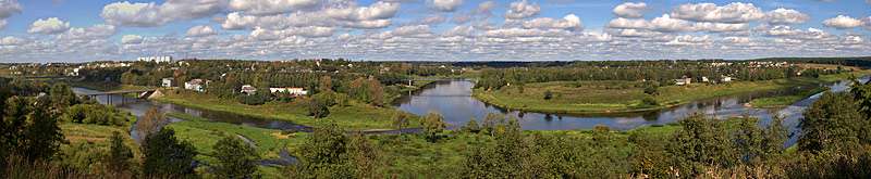 The Volga in Zubtsov, Tver Oblast
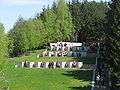 The World War II Memorial
..JPG) The Dormition Cathedral
The Dormition Cathedral
References
Notes
- 1 2 Law #34-ZO
- 1 2 3 4 Law #34-ZO stipulates that the borders of the settlements (administrative-territorial divisions) are identical to the borders of the urban and rural settlements (municipal divisions), and that the borders of the administrative districts are identical to the borders of the municipal districts. Law #25-ZO, which describes the borders and the composition of the municipal formations in Zubtsovsky Municipal District, lists the town of Zubtsov as a part and the administrative center of Zubtsov Urban Settlement of that district.
- 1 2 Государственный комитет Российской Федерации по статистике. Комитет Российской Федерации по стандартизации, метрологии и сертификации. №ОК 019-95 1 января 1997 г. «Общероссийский классификатор объектов административно-территориального деления. Код 28 218», в ред. изменения №259/2014 от 12 декабря 2014 г.. (State Statistics Committee of the Russian Federation. Committee of the Russian Federation on Standardization, Metrology, and Certification. #OK 019-95 January 1, 1997 Russian Classification of Objects of Administrative Division . Code 28 218, as amended by the Amendment #259/2014 of December 12, 2014. ).
- 1 2 3 4 5 Law #25-ZO
- 1 2 Russian Federal State Statistics Service (2011). "Всероссийская перепись населения 2010 года. Том 1" [2010 All-Russian Population Census, vol. 1]. Всероссийская перепись населения 2010 года (2010 All-Russia Population Census) (in Russian). Federal State Statistics Service. Retrieved June 29, 2012.
- ↑ Правительство Российской Федерации. Федеральный закон №107-ФЗ от 3 июня 2011 г. «Об исчислении времени», в ред. Федерального закона №271-ФЗ от 03 июля 2016 г. «О внесении изменений в Федеральный закон "Об исчислении времени"». Вступил в силу по истечении шестидесяти дней после дня официального опубликования (6 августа 2011 г.). Опубликован: "Российская газета", №120, 6 июня 2011 г. (Government of the Russian Federation. Federal Law #107-FZ of June 31, 2011 On Calculating Time, as amended by the Federal Law #271-FZ of July 03, 2016 On Amending Federal Law "On Calculating Time". Effective as of after sixty days following the day of the official publication.).
- 1 2 Энциклопедия Города России. Moscow: Большая Российская Энциклопедия. 2003. p. 149. ISBN 5-7107-7399-9.
- ↑ Почта России. Информационно-вычислительный центр ОАСУ РПО. (Russian Post). Поиск объектов почтовой связи (Postal Objects Search) (Russian)
- ↑ Russian Federal State Statistics Service (May 21, 2004). "Численность населения России, субъектов Российской Федерации в составе федеральных округов, районов, городских поселений, сельских населённых пунктов – районных центров и сельских населённых пунктов с населением 3 тысячи и более человек" [Population of Russia, Its Federal Districts, Federal Subjects, Districts, Urban Localities, Rural Localities—Administrative Centers, and Rural Localities with Population of Over 3,000] (XLS). Всероссийская перепись населения 2002 года [All-Russia Population Census of 2002] (in Russian). Retrieved August 9, 2014.
- ↑ Demoscope Weekly (1989). "Всесоюзная перепись населения 1989 г. Численность наличного населения союзных и автономных республик, автономных областей и округов, краёв, областей, районов, городских поселений и сёл-райцентров" [All Union Population Census of 1989: Present Population of Union and Autonomous Republics, Autonomous Oblasts and Okrugs, Krais, Oblasts, Districts, Urban Settlements, and Villages Serving as District Administrative Centers]. Всесоюзная перепись населения 1989 года [All-Union Population Census of 1989] (in Russian). Институт демографии Национального исследовательского университета: Высшая школа экономики [Institute of Demography at the National Research University: Higher School of Economics]. Retrieved August 9, 2014.
- ↑ Информация о районе (in Russian). Zubtsovsky District administration. Retrieved 8 April 2015.
- ↑ Залесский, Константин. Полный исторический атлас России (in Russian). Litres. ISBN 9785457542266.
- 1 2 3 Справка об изменениях в административно-территориальном делении Тверской губернии - Калининской области (in Russian). Архивы России. Archived from the original on April 19, 2012. Retrieved 1 March 2014.
- 1 2 Воробьёв, М. В. (1993). Г. В. Туфанова, ed. Административно-территориальное деление Смоленской области (in Russian). Государственный архив Смоленской области. pp. 118–133.
- 1 2 Малыгин, П. Д.; Смирнов, С. Н. (2007). История административно-территориального деления Тверской Области (PDF). Tver. pp. 14–15. OCLC 540329541.
- ↑ Зубцовский район (in Russian). Parliament of Tver Oblast. Retrieved 3 April 2015.
- ↑ Памятники истории и культуры народов Российской Федерации (in Russian). Russian Ministry of Culture. Retrieved 2 June 2016.
- ↑ Зубцовский краеведческий музей (in Russian). «Зубцов Онлайн». Retrieved 6 April 2015.
Sources
- Законодательное Собрание Тверской области. Закон №34-ЗО от 17 апреля 2006 г. «Об административно-территориальном устройстве Тверской области», в ред. Закона №66-ЗО от 1 октября 2014 г. «О внесении изменения в статью 18 Закона Тверской области "Об административно-территориальном устройстве Тверской области"». Вступил в силу со дня официального опубликования. Опубликован: "Тверские ведомости", №17 (специальный выпуск), 19 апреля 2006 г. (Legislative Assembly of Tver Oblast. Law #34-ZO of April 17, 2006 On the Administrative-Territorial Structure of Tver Oblast, as amended by the Law #66-ZO of October 1, 2014 On Amending Article 18 of the Law of Tver Oblast "On the Administrative-Territorial Structure of Tver Oblast". Effective as of the official publication date.).
- Законодательное Собрание Тверской области. Закон №25-ЗО от 28 февраля 2005 г. «Об установлении границ муниципальных образований, входящих в состав территории муниципального образования Тверской области "Зубцовский район", и наделении их статусом городского, сельского поселения», в ред. Закона №7-ЗО от 9 марта 2011 г. «О внесении изменения в Приложение №1 к Закону Тверской области "Об установлении границ муниципальных образований, входящих в состав территории муниципального образования Тверской области "Зубцовский район", и наделении их статусом городского, сельского поселения"». Вступил в силу со дня официального опубликования. Опубликован: "Тверские ведомости", №10, 11–17 марта 2005 г. (Legislative Assembly of Tver Oblast. Law #25-ZO of February 28, 2005 On Establishing the Borders of the Municipal Formations Comprised by the Territory of the Municipal Formation of "Zubtsovsky District" and on Granting Them the Status of Urban, Rural Settlements, as amended by the Law #7-ZO of March 9, 2011 On Amending Appendix 1 of the Law of Tver Oblast "On Establishing the Borders of the Municipal Formations Comprised by the Territory of the Municipal Formation of "Zubtsovsky District" and on Granting Them the Status of Urban, Rural Settlements". Effective as of the day of the official publication.).
- Законодательное Собрание Тверской области. Закон №4-ЗО от 18 января 2005 г. «Об установлении границ муниципальных образований Тверской области и наделении их статусом городских округов, муниципальных районов», в ред. Закона №65-ЗО от 24 июля 2012 г. «О внесении изменения в статью 2 Закона Тверской области "Об установлении границ муниципальных образований Тверской области и наделении их статусом городских округов, муниципальных районов"». Вступил в силу через десять дней после официального опубликования. Опубликован: "Тверские ведомости", №3, 21–27 января 2005 г. (Legislative Assembly of Tver Oblast. Law #4-ZO of January 18, 2005 On Establishing the Borders of the Municipal Formations of Tver Oblast and on Granting Them the Status of Urban Okrugs, Municipal Districts, as amended by the Law #65-ZO of July 24, 2012 On Amending Article 2 of the Law of Tver Oblast "On Establishing the Borders of the Municipal Formations of Tver Oblast and on Granting Them the Status of Urban Okrugs, Municipal Districts". Effective as of the day which is ten days after the official publication.).
| Cities and towns (all levels) | |||
|---|---|---|---|
| Closed administrative-territorial formations | |||
| Districts |
| ||