Staritsa (town), Tver Oblast
| Staritsa (English) Старица (Russian) | |
|---|---|
| - Town[1] - | |
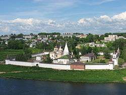 View of Staritsa, June 2008 | |
.svg.png) Location of Tver Oblast in Russia | |
 Staritsa | |
|
| |
_(1780).png) | |
|
| |
| Administrative status (as of December 2012) | |
| Country | Russia |
| Federal subject | Tver Oblast[1] |
| Administrative district | Staritsky District[2] |
| Urban settlement | Staritsa[2] |
| Administrative center of | Staritsky District,[3] Staritsa Urban Settlement[2] |
| Municipal status (as of July 2012) | |
| Municipal district | Staritsky Municipal District[4] |
| Urban settlement | Staritsa Urban Settlement[4] |
| Administrative center of | Staritsky Municipal District,[5] Staritsa Urban Settlement[4] |
| Statistics | |
| Population (2010 Census) | 8,607 inhabitants[6] |
| Time zone | MSK (UTC+03:00)[7] |
| Founded | 1297[8] |
| Previous names | Gorodok (until the 15th century) |
| Postal code(s)[9] | 171360, 171361, 171399 |
| Staritsa on Wikimedia Commons | |
Staritsa (Russian: Ста́рица) is a town and the administrative center of Staritsky District in Tver Oblast, Russia, located on the Volga River, 77 kilometers (48 mi) from Tver, the administrative center of the oblast. Population: 8,607 (2010 Census);[6] 9,125 (2002 Census);[10] 9,120 (1989 Census).[11]
History

The town was established in 1297 under the name of Gorodok (Городо́к), lit. small town).[8] In 1365, it was moved from the more elevated right to the lower left bank of the Volga River. Since the 15th century, the town has been called Staritsa (lit. former river-bed). The name was misinterpreted by heraldists who represented on Staritsa's coat of arms an image of aged nun, which is another meaning of the Russian word "staritsa". In the 14th century, it belonged to the Principality of Zubtsov, which was eventually was merged back into the Principlality of Tver. In 1485 it was formally annexed by the Grand Duchy of Moscow. The Golden Age of the town began. Between 1519 and 1597 the Principality of Staritsa, subordinate to Moscow, existed with the capital in Staritsa.[8] The principality was ruled by Ivan III's son Andrey, and then by Andrey's son Vladimir. While Ivan the Terrible had no children, Vladimir was regarded by boyars as his only heir. As the Tsar suspected Staritsa's ruler of plotting against him, Vladimir and his children were forced to take poison. The opulence of Staritsa during Vladimir's reign can be seen in the Dormition Monastery.
In the course of the administrative reform carried out in 1708 by Peter the Great, the area was included into Ingermanlandia Governorate (since 1710 known as Saint Petersburg Governorate), and in 1727 Novgorod Governorate split off. In 1775, Tver Viceroyalty was formed from the lands which previously belonged to Moscow and Novgorod Governorates, and the area was transferred to Tver Viceroyalty, which in 1796 was transformed to Tver Governorate. In 1775, Staritsky Uyezd was established, with the center in Staritsa. Much of the area of the district belonged to Staritsky Uyezd. The southern part of the District belonged to Zubtsovsky Uyezd, also established in 1775. On 3 March 1924, Staritsky Uyezd was abolished and split between Novotorzhsky, Rzhevsky, and Tverskoy Uyezds.[12]
On 12 July 1929, governorates and uyezds were abolished, and Staritsky District with the administrative center in the town of Staritsa was established. It belonged to Rzhev Okrug of Western Oblast.[13][14] On August 1, 1930 the okrugs were abolished, and the districts were subordinated directly to the oblast. On 29 January 1935 Kalinin Oblast was established, and Staritsky District was transferred to Kalinin Oblast.[12][13] During World War II, between 12 October 1941 and 1 January 1942, the town was occupied by the German army. In 1990, Kalinin Oblast was renamed Tver Oblast.[14]
Administrative and municipal status
Within the framework of administrative divisions, Staritsa serves as the administrative center of Staritsky District.[3] As an administrative division, it is incorporated within Staritsky District as Staritsa Urban Settlement.[2] As a municipal division, this administrative unit also has urban settlement status and is a part of Staritsky Municipal District.[4]
Economy
Industry
Main industries in Staritsa are a clothes factory, a flax-manufacturing factory, as well as mechanical and vegetable food factories.
Transportation
A railway connecting Torzhok and Rzhev has the Staritsa railway station, located about a dozen kilometers northeast of the town of Staritsa.
A paved road connecting Tver to Rzhev crosses the district and passes through Staritsa, where there is a bridge over the Volga. Another road connects Staritsa with Torzhok via Bernovo. There are also local roads with bus traffic originating from Staritsa.
The Volga is navigable but there is no passenger navigation.
Architecture

The town is split by the river into two parts: the larger left and the smaller right. There are numerous old abandoned limestone quarries in the town's vicinity, explaining an abundance of old limestone buildings in the town.
In the right part of a town a site of an old settlement can be clearly traced, with huge mounds and ground walls. On the opposing left bank of the river stands the Assumption Abbey, with a limestone cathedral from 1530 and a tented refectory from 1570. There are also several churches from the 18th and 19th centuries.
The cathedral of Sts. Boris and Gleb is a ponderous Neoclassical edifice erected from 1805 to 1820. It replaced a many-tented cathedral built in the 1560s by the same masters as worked on the famous St. Basil's Cathedral in Moscow. It was said that Moscow and Staritsa cathedrals were two sisters, just like the rulers of two towns, Ivan and Vladimir, were two brothers.
Staritsa contains 37 cultural heritage monuments of federal significance and additionally 121 objects classified as cultural and historical heritage of local significance. The federal monuments include, in particular, the ensemble of the center of Staritsa (with Dormition Monastery)[15] The Staritsa District museum, open in the town, concentrates on the history of the area.
Caves
Staritsa is also noted among speleologists for its 18th–19th century quarries. The quarries were created by local people, without any general plan, so they are sometimes very tangled and can be used as a smaller model for horizontal cave labyrinths. The longest quarries have a total length of passages of about 3 to 5 kilometers (1.9 to 3.1 mi). The passages are clean and dry, which is unusual for this region. A campaign is ongoing to try to have the quarries recognized as a local heritage site. In the meantime, they are gradually degrading due to lack of supervision.
References
Notes
- 1 2 Law #34-ZO
- 1 2 3 4 Law #34-ZO stipulates that the borders of the settlements (administrative-territorial divisions) are identical to the borders of the urban and rural settlements (municipal divisions), and that the borders of the administrative districts are identical to the borders of the municipal districts. Law #48-ZO, which describes the borders and the composition of the municipal formations in Staritsky Municipal District, lists the town of Staritsa as a part and the administrative center of Staritsa Urban Settlement of that district.
- 1 2 Государственный комитет Российской Федерации по статистике. Комитет Российской Федерации по стандартизации, метрологии и сертификации. №ОК 019-95 1 января 1997 г. «Общероссийский классификатор объектов административно-территориального деления. Код 28 253», в ред. изменения №259/2014 от 12 декабря 2014 г.. (State Statistics Committee of the Russian Federation. Committee of the Russian Federation on Standardization, Metrology, and Certification. #OK 019-95 January 1, 1997 Russian Classification of Objects of Administrative Division . Code 28 253, as amended by the Amendment #259/2014 of December 12, 2014. ).
- 1 2 3 4 Law #48-ZO
- ↑ Law #4-ZO
- 1 2 Russian Federal State Statistics Service (2011). "Всероссийская перепись населения 2010 года. Том 1" [2010 All-Russian Population Census, vol. 1]. Всероссийская перепись населения 2010 года (2010 All-Russia Population Census) (in Russian). Federal State Statistics Service. Retrieved June 29, 2012.
- ↑ Правительство Российской Федерации. Федеральный закон №107-ФЗ от 3 июня 2011 г. «Об исчислении времени», в ред. Федерального закона №271-ФЗ от 03 июля 2016 г. «О внесении изменений в Федеральный закон "Об исчислении времени"». Вступил в силу по истечении шестидесяти дней после дня официального опубликования (6 августа 2011 г.). Опубликован: "Российская газета", №120, 6 июня 2011 г. (Government of the Russian Federation. Federal Law #107-FZ of June 31, 2011 On Calculating Time, as amended by the Federal Law #271-FZ of July 03, 2016 On Amending Federal Law "On Calculating Time". Effective as of after sixty days following the day of the official publication.).
- 1 2 3 История Check
|url=value (help) (in Russian). Staritsa Town Administration. Retrieved 3 March 2015. - ↑ Почта России. Информационно-вычислительный центр ОАСУ РПО. (Russian Post). Поиск объектов почтовой связи (Postal Objects Search) (Russian)
- ↑ Russian Federal State Statistics Service (May 21, 2004). "Численность населения России, субъектов Российской Федерации в составе федеральных округов, районов, городских поселений, сельских населённых пунктов – районных центров и сельских населённых пунктов с населением 3 тысячи и более человек" [Population of Russia, Its Federal Districts, Federal Subjects, Districts, Urban Localities, Rural Localities—Administrative Centers, and Rural Localities with Population of Over 3,000] (XLS). Всероссийская перепись населения 2002 года [All-Russia Population Census of 2002] (in Russian). Retrieved August 9, 2014.
- ↑ Demoscope Weekly (1989). "Всесоюзная перепись населения 1989 г. Численность наличного населения союзных и автономных республик, автономных областей и округов, краёв, областей, районов, городских поселений и сёл-райцентров" [All Union Population Census of 1989: Present Population of Union and Autonomous Republics, Autonomous Oblasts and Okrugs, Krais, Oblasts, Districts, Urban Settlements, and Villages Serving as District Administrative Centers]. Всесоюзная перепись населения 1989 года [All-Union Population Census of 1989] (in Russian). Институт демографии Национального исследовательского университета: Высшая школа экономики [Institute of Demography at the National Research University: Higher School of Economics]. Retrieved August 9, 2014.
- 1 2 Справка об изменениях в административно-территориальном делении Тверской губернии - Калининской области (in Russian). Архивы России. Retrieved 1 March 2014.
- 1 2 Воробьёв, М. В. (1993). Г. В. Туфанова, ed. Административно-территориальное деление Смоленской области (in Russian). Государственный архив Смоленской области. pp. 118–133.
- 1 2 Малыгин, П. Д.; Смирнов, С. Н. (2007). История административно-территориального деления Тверской Области (PDF). Tver. pp. 14–15. OCLC 540329541.
- ↑ Памятники истории и культуры народов Российской Федерации (in Russian). Russian Ministry of Culture. Retrieved 2 June 2016.
Sources
- Законодательное Собрание Тверской области. Закон №34-ЗО от 17 апреля 2006 г. «Об административно-территориальном устройстве Тверской области», в ред. Закона №66-ЗО от 1 октября 2014 г. «О внесении изменения в статью 18 Закона Тверской области "Об административно-территориальном устройстве Тверской области"». Вступил в силу со дня официального опубликования. Опубликован: "Тверские ведомости", №17 (специальный выпуск), 19 апреля 2006 г. (Legislative Assembly of Tver Oblast. Law #34-ZO of April 17, 2006 On the Administrative-Territorial Structure of Tver Oblast, as amended by the Law #66-ZO of October 1, 2014 On Amending Article 18 of the Law of Tver Oblast "On the Administrative-Territorial Structure of Tver Oblast". Effective as of the official publication date.).
- Законодательное Собрание Тверской области. Закон №48-ЗО от 28 февраля 2005 г. «Об установлении границ муниципальных образований, входящих в состав территории муниципального образования Тверской области "Старицкий район", и наделении их статусом городского, сельского поселения», в ред. Закона №52-ЗО от 5 июля 2012 г. «О внесении изменений в Закон Тверской области "Об установлении границ муниципальных образований, входящих в состав территории муниципального образования Тверской области "Старицкий район", и наделении их статусом городского, сельского поселения"». Вступил в силу со дня официального опубликования. Опубликован: "Тверские ведомости", №10, 11–17 марта 2005 г. (Legislative Assembly of Tver Oblast. Law #48-ZO of February 28, 2005 On Establishing the Borders of the Municipal Formations Comprised by the Territory of the Municipal Formation of "Staritsky District" and on Granting Them the Status of Urban, Rural Settlements, as amended by the Law #52-ZO of July 5, 2012 On Amending the Law of Tver Oblast "On Establishing the Borders of the Municipal Formations Comprised by the Territory of the Municipal Formation of "Staritsky District" and on Granting Them the Status of Urban, Rural Settlements". Effective as of the day of the official publication.).
- Законодательное Собрание Тверской области. Закон №4-ЗО от 18 января 2005 г. «Об установлении границ муниципальных образований Тверской области и наделении их статусом городских округов, муниципальных районов», в ред. Закона №65-ЗО от 24 июля 2012 г. «О внесении изменения в статью 2 Закона Тверской области "Об установлении границ муниципальных образований Тверской области и наделении их статусом городских округов, муниципальных районов"». Вступил в силу через десять дней после официального опубликования. Опубликован: "Тверские ведомости", №3, 21–27 января 2005 г. (Legislative Assembly of Tver Oblast. Law #4-ZO of January 18, 2005 On Establishing the Borders of the Municipal Formations of Tver Oblast and on Granting Them the Status of Urban Okrugs, Municipal Districts, as amended by the Law #65-ZO of July 24, 2012 On Amending Article 2 of the Law of Tver Oblast "On Establishing the Borders of the Municipal Formations of Tver Oblast and on Granting Them the Status of Urban Okrugs, Municipal Districts". Effective as of the day which is ten days after the official publication.).
External links
- (Russian) Towns.ru. Staritsa
| Cities and towns (all levels) | |||
|---|---|---|---|
| Closed administrative-territorial formations | |||
| Districts |
| ||
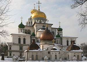
Historical towns and monasteries of the former Grand Duchy of Moscow | ||
|---|---|---|
 | ||