Woodlesford railway station
| Woodlesford | |
|---|---|
|
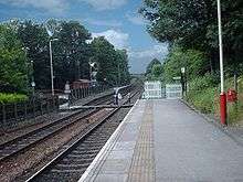
Platform 2 in 2011, with the new footbridge from platform 1 | |
| Location | |
| Place | Woodlesford |
| Local authority | City of Leeds |
| Coordinates | 53°45′24″N 1°26′35″W / 53.7568°N 1.4430°WCoordinates: 53°45′24″N 1°26′35″W / 53.7568°N 1.4430°W |
| Grid reference | SE368290 |
| Operations | |
| Station code | WDS |
| Managed by | Northern |
| Number of platforms | 2 |
| DfT category | F1 |
|
Live arrivals/departures, station information and onward connections from National Rail Enquiries | |
| Annual rail passenger usage* | |
| 2010/11 |
|
| 2011/12 |
|
| 2012/13 |
|
| 2013/14 |
|
| 2014/15 |
|
| Passenger Transport Executive | |
| PTE | West Yorkshire Metro |
| Zone | 2 |
| History | |
| Key dates | Opened 1840 |
| National Rail – UK railway stations | |
| * Annual estimated passenger usage based on sales of tickets in stated financial year(s) which end or originate at Woodlesford from Office of Rail and Road statistics. Methodology may vary year on year. | |
|
| |

Woodlesford railway station serves Woodlesford and Rothwell in West Yorkshire, England. It lies on the Hallam Line and the Pontefract Line.
Service
Monday to Saturdays there is a half-hourly service to Leeds and an hourly service to Sheffield on the Hallam Line and hourly towards Knottingley on the Pontefract Line.[1]
Sundays, there is an hourly service to Leeds and train every two hours to Sheffield and Knottingley respectively.
History
The station was opened in 1840 and formed part of the original North Midland Railway from Derby to Leeds built by George Stephenson.[2] During the early 20th century, coal trains from the nearby Water Haigh colliery provided regular goods traffic, as did the Armitage Quarries and Bentley's Yorkshire Brewery which had their own sidings. Parcels headed for the nearby town of Rothwell were unloaded here.

In late 2010 a footbridge was erected at the station to replace the crossing.[3]
Accidents and incidents
In 1850, a train was in a rear-end collision with an excursion train at the station. The cause was a signal not being lit at night.[4]
High Speed Two
Upon publication of the proposed route of the second phase of High Speed 2 on 28 January 2013, it emerged the HS2 line into Leeds would run parallel with the Pontefract Line from Woodlesford onwards. The plans show that to accommodate Woodlesford railway station, the high speed line will bypass north of the station and rejoin the path of the line for the remainder of the route into Leeds.[5] There will be no station at Woodlesford, the nearest High Speed station being Leeds New Lane.
References
- ↑ GB eNRT, December 2015 Edition, Table 32 & 34
- ↑ Pixton, B., (2000) North Midland: Portrait of a Famous Route, Cheltenham: Runpast Publishing
- ↑ Samuel, A. (27 January 2011). "Woodlesford bridge opens to improve pedestrian safety". Retrieved 9 June 2011.
- ↑ Hall, Stanley (1990). The Railway Detectives. London: Ian Allan. p. 26. ISBN 0 7110 1929 0.
- ↑ http://www.hs2.org.uk/phase-two/leeds
External links
- Train times and station information for Woodlesford railway station from National Rail
- The Story of Woodlesford Station http://www.woodlesfordstation.co.uk
| Preceding station | Following station | |||
|---|---|---|---|---|
| Northern Hallam Line | ||||
| Northern Pontefract Line | ||||
| Historical railways | ||||
| Methley Line open; station closed |
North Midland Railway Midland Railway |
Leeds City Line open; station open | ||