Wongawilli, New South Wales
| Wongawilli Wollongong, New South Wales | |||||||||||||
|---|---|---|---|---|---|---|---|---|---|---|---|---|---|
 | |||||||||||||
| Coordinates | 34°28.5′S 150°45.5′E / 34.4750°S 150.7583°ECoordinates: 34°28.5′S 150°45.5′E / 34.4750°S 150.7583°E | ||||||||||||
| Postcode(s) | 2530 | ||||||||||||
| Elevation | 24 m (79 ft) | ||||||||||||
| LGA(s) | City of Wollongong | ||||||||||||
| State electorate(s) | Shellharbour | ||||||||||||
| Federal Division(s) | Throsby | ||||||||||||
| |||||||||||||
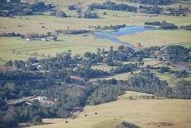
Wongawilli is a southern suburb of Wollongong, Australia at the foot hills of the Illawarra escarpment. The word 'Wonga' is a native aboriginal word meaning native pigeon.[1]
It contains a mixture of small rural properties and family homes. It has a NSW Rural Fire Service station and a small community hall where the Wongawilli colonial dance club meets regularly.[2] The community has had a long history with coal mining, with the Wongawilli colliery opening in 1916 by the Hoskins Brothers,[3] and later being taken over by BHP Billiton.[4] Since this time the mine has expanded and has had multiple owners, and is currently owned and operated by the Indian company Gujarat NRE.[5]
Notable residents
- Actor John Jarratt, born 1951
References
This article is issued from Wikipedia - version of the 7/2/2016. The text is available under the Creative Commons Attribution/Share Alike but additional terms may apply for the media files.