Minnamurra River
| Minnamurra River | |
| Open mature wave dominated barrier estuary[1] | |
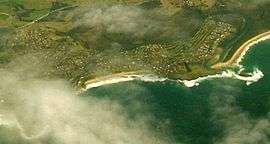 Aerial view showing the mouth of Minnamurra River. | |
| Name origin: Aboriginal: Meme Mora, meaning "river of many fish". | |
| Country | Australia |
|---|---|
| State | New South Wales |
| Regions | Sydney Basin (IBRA), Illawarra |
| Local government areas | Shellharbour, Kiama |
| Coordinates | 34°37′43″S 150°51′36″E / 34.62861°S 150.86000°ECoordinates: 34°37′43″S 150°51′36″E / 34.62861°S 150.86000°E |
| Source | Illawarra escarpment |
| - location | west of Jamberoo |
| Mouth | Tasman Sea, South Pacific Ocean |
| - location | Minnamurra Point, Minnamurra |
| Length | 23 km (14 mi) |
| Depth | 1 m (3 ft) |
| Volume | 1,517 m3 (53,572 cu ft) |
| Basin | 117 km2 (45 sq mi) |
| Area | 1.9 km2 (1 sq mi) |
| National park | Budderoo |
| Waterfall | Minamurra Falls |
 Location of river mouth in New South Wales
| |
| Website: NSW Environment & Heritage webpage | |
The Minnamurra River, an open mature wave dominated barrier estuary,[1] is located in the Illawarra region of New South Wales, Australia.
Location and features
Minnamurra River rises within the Budderoo National Park on the eastern slopes of the Illawarra escarpment, west of the village of Jamberoo and north of Missingham Pass, and flows generally east, descending the 100 metres (330 ft) Minamurra Falls.[2] The river drains into the Jamberoo Valley surrounded by Stockyard Mountain to the north, Jamberoo Mountain to the west and Noorinan and Saddleback Mountain to the south. The mouth of the river lies immediately north of the Kiama suburb of Minnamurra at Minnamurra Point. The entrance is characterised by a small island just offshore from the mouth. The river descends 306 metres (1,004 ft) over its 23 kilometres (14 mi) course.[2]
The Princes Highway crosses the Minnamurra River north of the suburb of Minnamurra.
The name Minnamurra is derived from the Aboriginal word of Meme Mora,[3] meaning "river of many fish".[4]
In 1893, four adults and three children were drowned whilst rowing a small boat near the mouth of the Minnamurra River. The boat succumbed to heavy surf conditions.[5]
See also
References
- 1 2 Roy, P. S; Williams, R. J; Jones, A. R; Yassini, I; et al. (2001). "Structure and Function of South-east Australian Estuaries". Estuarine, Coastal and Shelf Science. 53: 351–384. doi:10.1006/ecss.2001.0796.
- 1 2 "Map of Minamurra Falls, NSW". Bonzle Digital Atlas of Australia. Retrieved 18 May 2013.
- ↑ "Minnamurra River". Geographical Names Register (GNR) of NSW. Geographical Names Board of New South Wales. Retrieved 18 May 2013.
- ↑ Reed, A. W, (1984). Place names of Australia (paperback reprint). Sydney: Reed Books Pty Limited. p. 152.
- ↑ "Minnamurra River Tragedy" (Extract from the Reporter and Illawarra Journal and Sydney Mail). Kiama Museum. 1893. Retrieved 18 May 2013.
External links
- "Illawarra catchments". Office of Environment and Heritage (map). Government of New South Wales.
Rivers of the Southern Rivers catchment, New South Wales, Australia | |||||||
|---|---|---|---|---|---|---|---|
| |||||||
| |||||||
| |||||||
| |||||||
| |||||||
|