Yallah, New South Wales
| Yallah Shellharbour, New South Wales | |||||||||||||
|---|---|---|---|---|---|---|---|---|---|---|---|---|---|
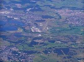 An aerial view of the area looking south, with Yallah, bottom left; Albion Park Rail, top left; Albion Park, top right; and Lake Illawarra, centre-left. | |||||||||||||
| Coordinates | 34°32′S 150°48′E / 34.533°S 150.800°ECoordinates: 34°32′S 150°48′E / 34.533°S 150.800°E | ||||||||||||
| Postcode(s) | 2530 | ||||||||||||
| LGA(s) | Shellharbour | ||||||||||||
| State electorate(s) | Shellharbour | ||||||||||||
| Federal Division(s) | Throsby | ||||||||||||
| |||||||||||||
Yallah is a western suburb in the City of Shellharbour, New South Wales, Australia, located on the western shore of Lake Illawarra. It contains a mixture of rural, commercial and light industrial areas.
Etymology
Yallah is an Australian Aboriginal word for which a number of meanings are given; native apple tree; a nearby lagoon; and "go away at once".[1]
Developments
The Tallawarra Power Station on the shores of Lake Illawarra and adjacent to Yallah was commissioned in 1952 and commenced operations in 1954 as a thermal power station. The station closed in 1989 and was reconditioned as a 435-megawatt (583,000 hp) combined cycle natural gas power station.[1]
The Yallah railway station opened in 1887,[1] and closed in 1974.[2]
The Princes Motorway southern terminus is located south of Yallah and north of Albion Park Rail, at the junction of the Princes Highway with the Illawarra Highway.
See also
References
- 1 2 3 "Online resources: Suburb Profiles". City of Wollongong. 19 October 2012. Retrieved 10 October 2016.
- ↑ "Yallah Station". www.nswrail.net. Retrieved 7 February 2016.