Wilson Peak
| Wilson Peak | |
|---|---|
|
Wilson peak photographed from the Telluride Ski Resort | |
| Highest point | |
| Elevation | 14,023 ft (4,274 m) [1][2] |
| Prominence | 857 ft (261 m) [2] |
| Isolation | 1.51 mi (2.43 km) [2] |
| Listing | |
| Coordinates | 37°51′37″N 107°59′05″W / 37.8602716°N 107.984791°WCoordinates: 37°51′37″N 107°59′05″W / 37.8602716°N 107.984791°W [3] |
| Geography | |
 Wilson Peak | |
| Location | High point of San Miguel County, Colorado, United States[2] |
| Parent range | San Miguel Mountains[2] |
| Topo map |
USGS 7.5' topographic map Mount Wilson, Colorado[3] |
| Climbing | |
| Easiest route | Southwest ridge from Silver Pick or Navajo Basins |
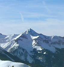
Wilson Peak is a 14,023-foot (4,274 m) mountain peak in the U.S. state of Colorado. It is located in the Lizard Head Wilderness of the Uncompahgre National Forest, in the southern San Juan Mountains. It is the highest point in San Miguel County. Its base is accessible by four wheel drive roads 11 miles (18 km) west of Telluride, Colorado.
Wilson Peak is part of a compact range of mountains, the San Miguel Range often considered distinct from the wider San Juan Range. Two additional fourteen thousand foot peaks are within 2 miles (3 km) of its summit: Mount Wilson (14,256 feet (4,345 m)) and El Diente Peak (14,159 feet (4,316 m)). Gladstone peak (13,913 feet (4,241 m)) is located on the ridge between Wilson Peak and Mount Wilson. Also known as the Wilson Massif, the San Miguels are some of the westernmost San Juans.
Wilson Peak is climbed by hundreds each year, primarily in summer months, but winter ascents are not unusual and sometimes serve as the beginning of backcountry skiing descents. Summer ascents of the peak are considered Class 3 technical climbs, meaning that scrambling over rock is required (with hand holds being used for balance) and ropes typically not employed. The easiest traditional route begins at the end of the Silver Pick Road, climbs south through Silver Pick Basin to the Rock of Ages Saddle (between Silver Pick and Navajo Basins) at 13,100 feet (3,990 m), then east to 13,200 feet (4,020 m) on the saddle between Gladstone and Wilson Peaks, then finally northeast to the summit. Round trip distance is 8 miles (13 km). Use of this route has come into question since 2004 when private landowners failed to come to an agreement with the US Forest Service regarding hiking access. Government signs now warn against trespassing along the traditional route.
In popular culture
The stately and classically mountainous profile of Wilson Peak as viewed from the East and North has led to its use as a symbol of rugged mountains in advertising. Wilson Peak features prominently in many television advertisements for Coors Brewing Company which is located in Golden, Colorado. The Jeep automobile corporation also often uses Wilson Peak as a backdrop in its television commercials, particularly in advertisements for its off-road models.
Because of its proximity to Telluride, Colorado, many local companies and festivals use images of Wilson Peak in the advertising to convey the beauty and mountainous nature of the area.
See also
References
- ↑ The elevation of Wilson Peak includes an adjustment of +1.877 m (+6.16 ft) from NGVD 29 to NAVD 88.
- 1 2 3 4 5 "Wilson Peak, Colorado". Peakbagger.com. Retrieved October 23, 2014.
- 1 2 "Wilson Peak". Geographic Names Information System. United States Geological Survey. Retrieved October 23, 2014.
External links
- Wilson Peak, Mt. Wilson and El Diente Peak on 14ers.com
- Traditional Route, with discussion of private land restrictions
- Wilson Peak on Distantpeak.com
- A gallery of photographs of Wilson Peak
- Topographic map
- Access and Preservation Project for Wilson Peak
