West Sunbury, Pennsylvania
| West Sunbury, Pennsylvania | |
|---|---|
| Borough | |
|
| |
 West Sunbury | |
| Coordinates: 41°00′22″N 79°53′46″W / 41.00611°N 79.89611°WCoordinates: 41°00′22″N 79°53′46″W / 41.00611°N 79.89611°W | |
| Country | United States |
| State | Pennsylvania |
| County | Butler |
| Settled | 1828 |
| Incorporated | 1866 |
| Government | |
| • Type | Borough Council |
| • Mayor | Richard Wagner |
| Area | |
| • Total | 0.1 sq mi (0.3 km2) |
| • Land | 0.1 sq mi (0.3 km2) |
| • Water | 0.0 sq mi (0.0 km2) |
| Population (2010) | |
| • Total | 192 |
| • Density | 1,744/sq mi (673.4/km2) |
| Time zone | Eastern (EST) (UTC-5) |
| • Summer (DST) | EDT (UTC-4) |
| Zip code | 16061 |
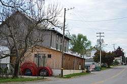
West Sunbury is a borough in Butler County, Pennsylvania, United States. The population was 192 at the 2010 census.[1]
Geography
West Sunbury is located in north-central Butler County at 41°0′22″N 79°53′46″W / 41.00611°N 79.89611°W (41.006153, -79.896107).[2] Pennsylvania Routes 138 and 308 run together through the center of the borough as Main Street. By PA 308 it is 10 miles (16 km) south to Butler, the county seat.
According to the United States Census Bureau, West Sunbury has a total area of 0.11 square miles (0.29 km2), all of it land.[1]
Demographics
| Historical population | |||
|---|---|---|---|
| Census | Pop. | %± | |
| 1870 | 216 | — | |
| 1880 | 243 | 12.5% | |
| 1890 | 238 | −2.1% | |
| 1900 | 254 | 6.7% | |
| 1910 | 283 | 11.4% | |
| 1920 | 217 | −23.3% | |
| 1930 | 246 | 13.4% | |
| 1940 | 259 | 5.3% | |
| 1950 | 262 | 1.2% | |
| 1960 | 252 | −3.8% | |
| 1970 | 216 | −14.3% | |
| 1980 | 203 | −6.0% | |
| 1990 | 177 | −12.8% | |
| 2000 | 104 | −41.2% | |
| 2010 | 192 | 84.6% | |
| Est. 2015 | 188 | [3] | −2.1% |
| Sources:[4][5][6] | |||
As of the census[5] of 2000, there were 104 people, 42 households, and 25 families residing in the borough. The population density was 1,021.8 people per square mile (401.5/km²). There were 47 housing units at an average density of 461.8 per square mile (181.5/km²). The racial makeup of the borough was 100.00% White. Hispanic or Latino of any race were 1.92% of the population.
There were 42 households, out of which 33.3% had children under the age of 18 living with them, 47.6% were married couples living together, 14.3% had a female householder with no husband present, and 38.1% were non-families. 31.0% of all households were made up of individuals, and 14.3% had someone living alone who was 65 years of age or older. The average household size was 2.48 and the average family size was 3.19.
In the borough the population was spread out, with 26.9% under the age of 18, 7.7% from 18 to 24, 27.9% from 25 to 44, 22.1% from 45 to 64, and 15.4% who were 65 years of age or older. The median age was 36 years. For every 100 females there were 116.7 males. For every 100 females age 18 and over, there were 76.7 males.
The median income for a household in the borough was $25,625, and the median income for a family was $33,750. Males had a median income of $27,000 versus $15,750 for females. The per capita income for the borough was $12,643. There were 14.8% of families and 21.3% of the population living below the poverty line, including 32.1% of under eighteens and 12.5% of those over 64.
Schools
Students in the borough and surrounding region belong to the Moniteau School District Children in kindergarten through sixth grade receive education at the only elementary school, Dassa McKinney, located east of borough. Students continue their education at Moniteau Jr./Sr. High School, located to the north of borough.
Notable people
- Janet Anderson, 1982 U.S. Women's Open golf champion
- Bob Glenn, baseball player
- Brice Schwab, American football player
References
- 1 2 "Geographic Identifiers: 2010 Demographic Profile Data (G001): West Sunbury borough, Pennsylvania". U.S. Census Bureau, American Factfinder. Retrieved March 27, 2014.
- ↑ "US Gazetteer files: 2010, 2000, and 1990". United States Census Bureau. 2011-02-12. Retrieved 2011-04-23.
- ↑ "Annual Estimates of the Resident Population for Incorporated Places: April 1, 2010 to July 1, 2015". Retrieved July 2, 2016.
- ↑ "Census of Population and Housing". U.S. Census Bureau. Retrieved 11 December 2013.
- 1 2 "American FactFinder". United States Census Bureau. Retrieved 2008-01-31.
- ↑ "Incorporated Places and Minor Civil Divisions Datasets: Subcounty Resident Population Estimates: April 1, 2010 to July 1, 2012". Population Estimates. U.S. Census Bureau. Retrieved 11 December 2013.
External links
| Counties |  Map of the Pittsburgh Tri-State with green counties in the metropolitan area and yellow counties in the combined area. | |
|---|---|---|
| Major cities | ||
| Cities and towns 15k-50k (in 2010) | ||
| Airports | ||
| Topics | ||
| ||
Municipalities and communities of Butler County, Pennsylvania, United States | ||
|---|---|---|
| City | 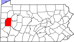 | |
| Boroughs | ||
| Townships | ||
| CDPs | ||
| Unincorporated communities | ||
| Footnotes | ‡This populated place also has portions in an adjacent county or counties | |