West Denton, Maryland
| West Denton, Maryland | |
|---|---|
| Census-designated place | |
 West Denton | |
| Coordinates: 38°53′19″N 75°50′20″W / 38.88861°N 75.83889°WCoordinates: 38°53′19″N 75°50′20″W / 38.88861°N 75.83889°W | |
| Country | United States |
| State | Maryland |
| County | Caroline |
| Area | |
| • Total | 0.30 sq mi (0.77 km2) |
| • Land | 0.30 sq mi (0.77 km2) |
| • Water | 0 sq mi (0 km2) |
| Elevation | 5 ft (2 m) |
| Population (2010) | |
| • Total | 52 |
| • Density | 176/sq mi (67.8/km2) |
| Time zone | Eastern (EST) (UTC-5) |
| • Summer (DST) | EDT (UTC-4) |
| Area code(s) | 410 |
| FIPS code | 24-82625 |
| GNIS feature ID | 0591517 |
West Denton is an unincorporated community and census-designated place (CDP) in Caroline County, Maryland, United States.[1] As of the 2010 census it had a population of 52.[2]
It is located on the west bank of the Choptank River, across from Denton, the Caroline County seat. Maryland Route 404 Business crosses the Choptank and the oldest portion of the community on a bridge constructed in 1979. Maryland Route 328 forms the western edge of the CDP, and the Maryland Route 404 bypass (Shore Highway) forms the northern edge, crossing the Choptank on the Governor Harry R. Hughes Bridge, constructed in 1982.
Located at West Denton are the Neck Meetinghouse and Yard and West Denton Warehouse-Wharf, both listed on the National Register of Historic Places.[3]
References
- ↑ U.S. Geological Survey Geographic Names Information System: West Denton, Maryland
- ↑ "Geographic Identifiers: 2010 Demographic Profile Data (G001): West Denton CDP, Maryland". U.S. Census Bureau, American Factfinder. Retrieved August 22, 2014.
- ↑ National Park Service (2008-04-15). "National Register Information System". National Register of Historic Places. National Park Service.
Municipalities and communities of Caroline County, Maryland, United States | ||
|---|---|---|
| Towns | 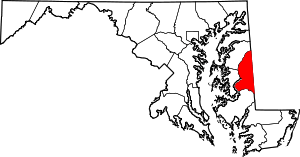 | |
| CDPs | ||
| Unincorporated communities | ||
| Footnotes | ‡This populated place also has portions in an adjacent county or counties | |