Wangford Hundred
Wangford was a hundred of Suffolk, England, consisting of 34,679 acres (140.34 km2).[1]
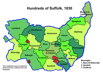
Wangford Hundred was an area of around twelve miles (19 km) from west to east and five across. The River Waveney formed its northern border separating it from Norfolk. To the east lay Mutford and Lothingland Hundred, to the south Blything Hundred and to the west Hoxne Hundred.
It is a fertile district, particularly in the broad vale of the Waveney with its rich marshes for feeding cattle. On the south side of the vale the land becomes hilly with an agricultural region of predominantly loam soil. The towns of Bungay and Beccles are the largest settlements in the former hundred. The hundred also contained the thirteen parishes (Ilketshall, South Elmham, Flixton and Homersfield) collectively known as The Saints.
Listed as Wanneforda (inter alia) in the Domesday Book, the name is believed to derive from an alternative name for the Waveney and thus to mean "ford across the Waveney". A total of 24 places with a population of around 1025 households are mentioned in the Domesday Book.[2] It is not to be confused with the two other Wangfords in Suffolk.[3]
Parishes
Wangford Hundred consisted of the following 27 parishes:[1][4]
| Parish | Area (acres) |
|---|---|
| Barsham | 1871 |
| Beccles | 1994 |
| Bungay | 2090 |
| Ellough | 1074 |
| Flixton | 1762 |
| Homersfield | 981 |
| Ilketshall St Andrew | 1696 |
| Ilketshall St John | 743 |
| Ilketshall St Lawrence | 988 |
| Ilketshall St Margaret | 2093 |
| Mettingham | 1706 |
| North Cove | 1082 |
| Redisham | 733 |
| Ringsfield | 1700 |
| Shadingfield | 1370 |
| Shipmeadow | 800 |
| Sotterley | 1594 |
| South Elmham, All Saints | 1150 |
| South Elmham, St Cross | 1301 |
| South Elmham, St James | 1302 |
| South Elmham, St Margaret | 589 |
| South Elmham, St Michael | 816 |
| South Elmham, St Nicholas | 500 |
| South Elmham, St Peter | 576 |
| Weston | 1551 |
| Willingham St Mary | 890 |
| Worlingham | 1727 |
References
- 1 2 William White (1844). History, gazetteer, and directory of Suffolk. p. 410.
- ↑ Wangford Hundred, Domesday Map. Retrieved 2011-04-18.
- ↑ Walter Skeat (1913). The Place-names of Suffolk.
- ↑ 1841 Census
Coordinates: 52°24′N 1°27′E / 52.4°N 1.45°E